Short Version:
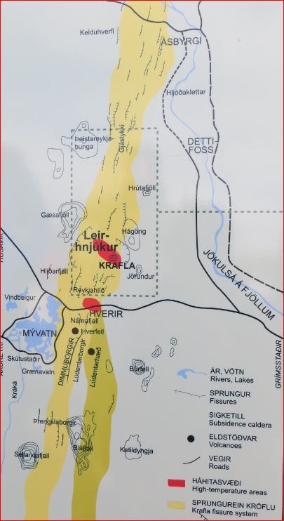
Kröflueldar ist the icelandic name of Krafla Fires. Krafla is one of Iceland's most spectacular and most active volcanoes. Krafla is a central volcano in North-East of Myvatn lake and has a 10-km-wide caldera, that was formed around 100,000 years ago by a violent ryhyolitic tuff-forming eruption. The caldera is cut by a North-South-trending fissure system. Krafla has been the source of many rifting and eruptive events during the Holocene, including two in historical time, during 1724-29 and 1975-84. The prominent Hverfjall and Ludent tuff rings east of Myvatn were erupted along the 100-km-long fissure system, which extends as far as the north coast of Iceland.
Source: GVP, Smithsonian Institution
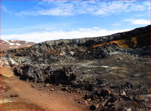
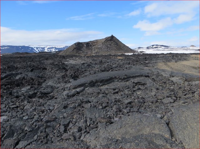
The Leirhnjukur area is a central volcano with absolutely relatively new barren lava fields, where the Apollo 11 crew, came in the late 60's to train for their impending moonwalks.
From the parking area near Mt. Leirhnjukur lies an easy trail to the mountain. The route then leads through a hot spring area, into craters formed in the Krafla fires and to the summit. From there the route lies back to the parking area. Altogether hike takes one to one and a half hours.
A trail lies between the information center in "Reykjahlid" and Mt. Leirhnjukur. It lies from the Leirhnjukur and through a crater area.
From there, the route continues through lava and gravel banks to "Mt. Hlidarfjall", along the bank of the river "Elda" back down to the information center. The "Mt. Krafla" route takes 3-4 hours to walk and is fairly easy.
"The Myvatnseldar" eruptions (the “Myvatn fires”) in 1724 began with a great volcanic explosion which formed the crater "Stora - Viti".
In the following years, a series of earthquakes and eruptions occurred in the vicinity of "Krafla" mountain. The greatest eruption took place in 1729, when lava flowed from Leirhnjukur mountain down to Myvatn lake. "Eldhraun", the lava field formed during the eruptions.
A new series of eruptions (the "Krafla-fires") began in Krafla in 1975, after an intermission of about 250 years. In the following nine years, nine eruptions occurred.
One hundred thousand years ago, there was a volcanic cone here that caved in after erupting. The caldera thus formed is now filled with younger volcanic material. Below at a depth of about 3 km, however, is a magma chamber. Volcanic activity in the area occurs at intervals of several centuries.
Magma flows into the chamber, which expands and raises the ground. The chamber then bursts and magma flows through underground fissures to the north or south. A part of the magma may then surface in an eruption. As the pressure in the magma chamber decreases, the land subsides quickly. This process repeats itself every few months for several years running.
+++++++++++++++++++++++++++++++++++++++++++++++++++++++++++++++++++
The Krafla central volcano forms a low, broad shield some 25 km in diameter, with a caldera in its centre. The caldera measures about 10 km east-west and about 8 km north-south. It formed during the last interglacial period and has since been filled almost to the rim with volcanic material.
The collapse of the caldera probably followed the eruption of a sheet of dacitic welded tuff which is exposed around the caldera. This welded tuff was produced by an explosive eruption within the Krafla caldera. A lava shield with a diameter of about 20 km existed prior to the caldera formation. The Krafla fissure swarm is about 90 km long and 4-10 km wide, with over 1000 tectonic fractures.
Historical accounts mention only one eruption episode in the Krafla-Námafjall fissure swarm in the years 1724-1729.
Contemporary descriptions of this eruption, the "Mývatn fires" exist. The lava flows cover an area of about 34 km and the total length of the discontinuous volcanic fissure is 11 km. A minor volcanic eruption was reported on the same fissure in 1746 accompanied by earthquakes and ground movements. Field investigations indicate that it occurred to the north and south of Leirhnjúkur located near the centre of the Krafla caldera.
The events that took place in the Krafla caldera and on the Krafla fissure swarm during 1975-84 (The Krafla fires) are a striking repetition of what happened during the "Mývatn fires" in the 1720's. Following the last eruption of this episode in September 1984, the Krafla magma chamber inflated again eventually fully recovering previous land elevation. During 1989-92 land subsided at 5 cm/yr but during 1992-95 by 2.4 cm/yr.
The volcanism within the Krafla system is compositionally bimodal, the historic volcanism is being dominated by tholeiitic basalt production.
Compiled by Guðrún Sverrisdóttir in January 2012.
Visit this hot and interesting area.
And now are Questions, to log this Earthcache
Go to the Earthcache coordinates
1) What will you find here? Estimate how wide it is.
2) Describe the color of the rock there. Find a geological explanation. Why did the rock this color?
3) Is the rock there hot or cold? Find a geological explanation for this.
4) What is the Leirhnjukur for a geological formation? How high it is above sea level? As it rises out of the surrounding lava fields?