Our town of Needham has had a different geologic history than some of the surrounding towns. About 570,000,00 to 1,000,000 years ago, volcanoes erupted and “tuff,” ash that was many feet deep, covered parts of Needham. The rocks around Claxton Field (Central Avenue across from the Transfer Station) were created from firmly cemented tuff.
About a million years ago, the earth cooled enough so that massive ice sheets, known as “continental glaciers” formed in Northern Canada. The ice sheets did not melt during the summer and got larger and thicker as each winter passed. Eventually, the ice at the bottom of the ice sheets started to move toward New England. Needham was changed greatly since this particular glacier was hundreds of miles long and it pushed and flattened anything in its path.
The glacier repeatedly advanced and retreated through Needham until about 16,000 years ago. At times our town was covered with ice that was several thousand feet deep. Each time it advanced it scraped the surface of the earth taking with it debris composed of pieces from the size of dust particles to boulders. It pushed through our town where it left hundreds of tons of debris piled up that we call “hills.” This action created seven major hills in Needham.
Do you know that when you are in Boston’s Back Bay, you are actually standing on Needham soil? “Back Bay was formed from Needham soil. Starting in 1858, for more than 30 years, trains from Needham were loaded with gravel and dirt to fill up the marsh known as Back Bay to make a new part of the city. Trains ran day and night, making 16 trips, and pulled 35 loaded cars into Boston each day. [If you want to ride along the same route, take the MBTA Green Line D - Riverside, which comes close to following the same path.] In total, 112 acres of Needham were turned into a desert by the removal of the soil. 570 acres of gravel were taken to Boston by train. There used to be a hill near the Kendrick Bridge that is now lying under the Prudential Center and John Hancock Tower in the Back Bay. This east Needham area has now become the New England Industrial Center along route 128.”(1) Needham is now left with just six hills: Great Plain Avenue Area, High Rock, Birds Hill, Ridge Hill, High School Hill, and North Hill.
As the glacier flowed through Needham, it also created a “kettle hole.” “A kettle hole is formed by blocks of ice that are separated from the main glacier - perhaps the ice front stagnated or retreated or perhaps ice blocks were washed out from the glacier during a glacier flood or “jökulhaup”. If conditions are right, the isolated blocks of ice then become partially or wholly buried in outwash. When the ice blocks eventually melt they leave behind holes or depressions that fill with water to become kettle hole lakes.” The picture below shows how a kettle hole is formed as the buried ice blocks slowly melted.(2)
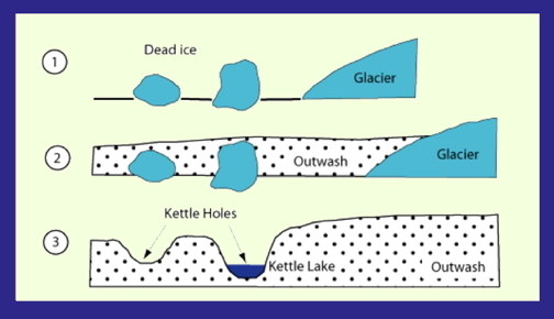
Kettle holes can be as small as 115 feet or as large as 8 miles in diameter. When kettle holes are filled with water, they are called, “kettle lakes.” Characteristically, the water in kettle lakes is cold, acidic and low in nutrients. The lakes are most often round because melting blocks of ice tend to be rounded. Sometimes irregular ice masses cause distorted or branching depressions. Rosemary Lake in Needham started out as a kettle hole that was a meadow. In the early 1700’s a dam was built which backed up the brook and created a mill pond. This pond was used for power for local industries, including an unsuccessful effort to cultivate silkworms.
In the 1940's, Rosemary Lake became the town's main public swimming area. In the 1960's, however, it was closed to swimming due to its murky water and other environmental concerns. In 1972, the town built a pool within the lake that filtered and chlorinated water from the lake. "Rosemary Pool is a rarity: a pool built inside a lake, separated by an underwater wall called a "cofferdam"(3)(a watertight enclosure placed or constructed in waterlogged soil or under water and pumped dry so that construction or repairs can proceed under normal conditions")(4)
To receive credit for this earth cache, go to the coordinates listed above. Then submit the answers to the following questions to the cache owners:
1. What was in the material from one of the hills in Needham that made it a good material for creating the Back Bay?
2. How do you think Rosemary Lake was formed?
3. How wide is the lake from where you are standing to the other side?
4. Describe the banks of the lake. Why do you think they look like they do?
(1) Adrian M Hall, Department of Physical Geography and Quaternary Geology, University of Stockholm
(2) Eliot School Science Curriculum, Needham, MA
(3) WickedLocal.com, May 16, 2013
(4) Dictionary.com