The "From the Top" cache is located in the Greater Austin area. The cache is not at the coordinates listed above!
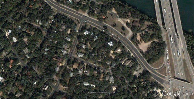
This cache is located 4.09 miles from the coordinates of N30° 17.737’, W097° 41.687’. The aerial photograph shown below is a picture of the cache site. The photo has not been rotated from the original source.
Draw a straight line from the upper right corner of the picture to the bottom left corner. Near the top right, the line will intersect a road. From this location, walk 102 feet at 87 degrees. Coordinates for the container will be found at this area. The container is less than 500 feet away.
Interpreting Aerial Photographs
Interpreting an aerial photograph requires a little skill. People spend years becoming proficient photo-interpreters, and the amateur or casual user of these images is wise to spend a few minutes learning to distinguish a small cloud shadow from a small lake, an air force base from a civilian airport, or a stand of young timber from a grassy hillside.
What to Look For
Aerial photographs contain a lot of information, anomalies in drainage patterns, landforms to make deductions about the subsurface and structures will identify the area. The interpreters are likely to examine the photographs and USGS topographic maps together, perhaps alternating between the two to connect place names and road numbers with unidentified features in the photographs.

Here is the image: