Limestone Cliff Schwarzenbergpark EarthCache
Limestone Cliff Schwarzenbergpark
-
Difficulty:
-

-
Terrain:
-

Size:  (other)
Please note Use of geocaching.com services is subject to the terms and conditions
in our disclaimer.
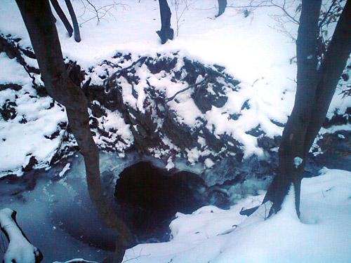
Limestone cliff in the Schwarzenbergpark (Vienna).
Kalkklippe im Schwarzenbergpark
Be careful and do not destroy anything!
Das Gebiet des Wienerwalds ist etwa 1.000 Quadratkilometer
groß und ist ein großteils bewaldete Region der
nördlichen Kalkalpen im östlichen Niederösterreich
und Wien. Obwohl der nördliche Teil des Wienerwaldes aus
Sandstein besteht, legt der Eckbach hier eine Kalkklippe frei. Der
Kalkstein ist ca. 140 Mio. Jahre alt (Jura/Kreide) und ist
Aptychenkalk. Der durch die Tektonik (Gebirgsbau) aus der Tiefe
emporgepresste, harte Kalk wird von weicheren, bunten Schiefertonen
umhüllt und gehört mit diesen der Hauptklippenzone
an.
Die Klippe und der kleinen Wasserfall mit Tosbecken kann leicht vom
Weg neben dem Fluss, ohne Betreten des Waldes oder Baches gefunden
werden.
Für die Gültigkeit des Logs mußt du die Antworten
auf folgende Fragen an
vici97@gmx.net senden:
1) In welche Richtung fließt der Eckbach?
2) Wie hoch schätzt du den aktuellen
Wasserdurchfluß?
3) Beschreibe den Felsen.
4) Ein Photo vom Bach im Log ist sehr erwünscht.
The region of the Vienna Woods (German: Wienerwald) covers 1.000
square kilometers. It is a wooded section of the Northern Alps in
eastern Lower Austria and Vienna. Although the northern part of the
Vienna Woods is based on sandstone, the small creek Eckbach exposes
a limestone cliff.
This limestone is about 140 Mio years old ( Jurassic / Cretaceous)
and is based on Aptychus chalk. The tectonics pressed the hard
limestone from the depth. The limestone is wrapped by colored
clay.
The cliff and the small waterfall with a plunge pool can be seen
easily from the trail next to the river without entering the woods
or crossing the creek.
Tasks for the validation of the log (send answers to
vici97@gmx.net ):
1) Determine the direction in which the creek goes.
2) Estimate the current flow rate.
2) Describe the cliff.
4) A photo of the creek in the log is highly appreciated.
Good luck.
Additional Hints
(Decrypt)
Fgnl ba gur yrsg evirefvqr