Questa cache è stata pubblicata il 20 agosto 2016 in occasione del “La Maddalena geocaching-day event”
This cache was published August 20, 2016 on the occasion of "La Maddalena geocaching-day event"
Cette cache a été publié le 20 Août, 2016 au "La Maddalena geocaching-day event"

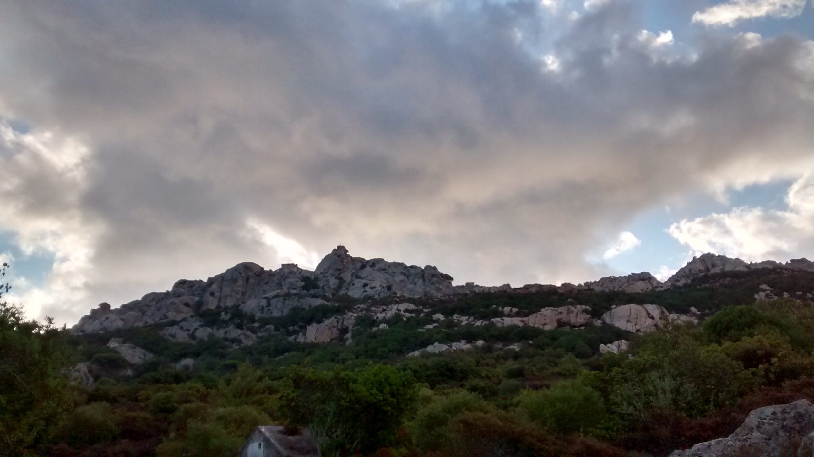
Questa multi vi porterà dal punto di partenza dove parcheggiate il vostro mezzo sino alla sommità del Monte Tejalone, la montagna più alta dell’arcipelago con i suoi 212 metri. E’ una passeggiata di circa 20 minuti che può essere affrontata in tranquillità ma usando scarpe chiuse. L’ultima parta è caratterizzata da una ripida scalinata da affrontare con la dovuta attenzione.
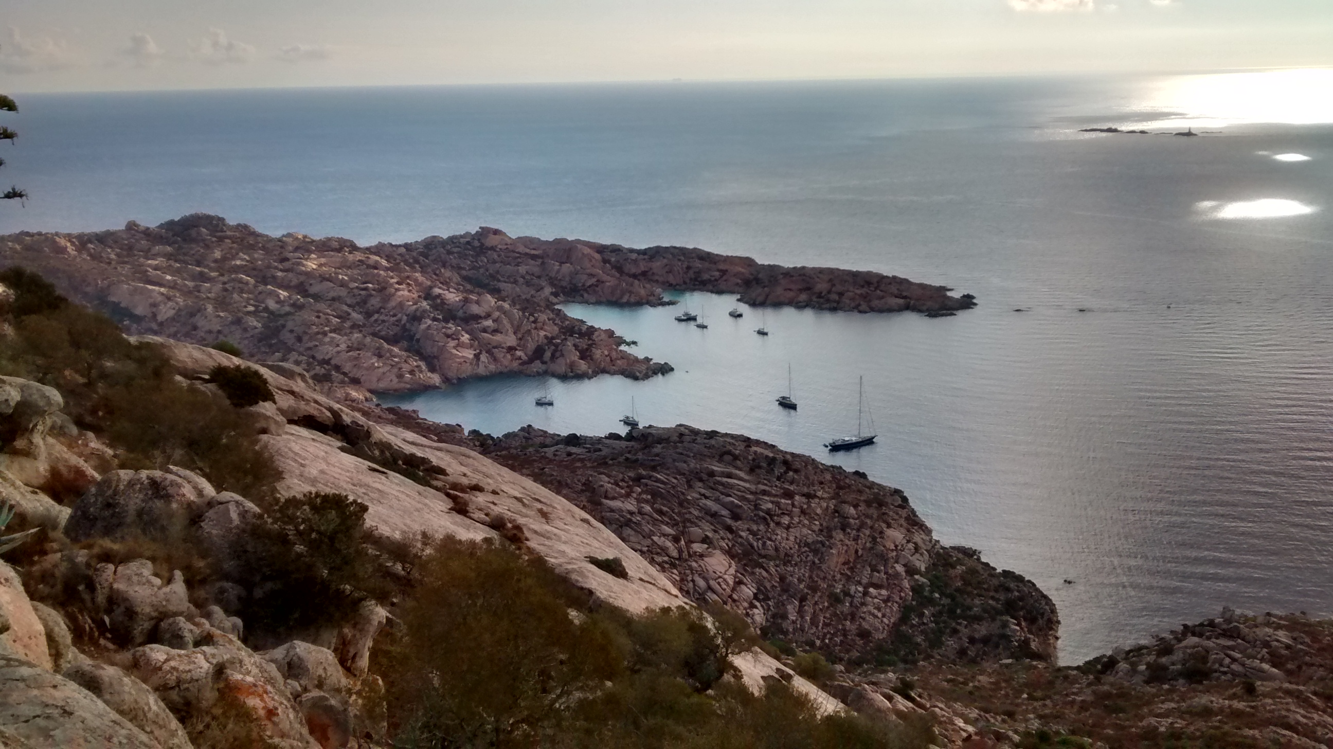
Sulla sommità potrete godere di una vista unica a 360 gradi. In basso ammirerete Cala Coticcio, in lontananza gli isolotti dei Monaci, tutto l’arcipelago e la Sardegna. Nelle giornate di forte maestrale (fare attenzione agli ultimi metri sugli scalini) avrete l’impressione di essere sul ponte di un enorme bastimento che solca il mare increspato dalle onde. Se siete fortunati incontrerete anche le capre selvatiche. Guardatele tranquillamente senza però infastidirle.
Monte Tejalone
Il Monte Tejalone (212 mt) fa parte di un unico massiccio granitico che si estende per quattro chilometri e attraversa l’isola di Caprera da nord a sud.
Al di sotto della cima vennero posizionati gli apparati utilizzati per effettuare importanti esperimenti sulla trasmissione delle onde radio. Il 6 ottobre 1901 venne effettuato da Guglielmo Marconi il primo segnale radiotelegrafico Monte Tejalone – Monte Argentario.
La cache
Lasciato il parking imboccate il sentiero 07 che inizia a pochi metri di distanza. Sconsiglio di intraprendere il percorso con scarpe da spiaggia !! Ricordatevi che in qualche punto il segnale GPS non è perfetto quindi in prossimità degli stage utilizzate anche gli hint per trovare le indicazioni per gli stage successivi.
STAGE 1
Recarsi alle coordinate N 41°12.918 E 009°28.332 e cercate sotto un sasso: troverete la parola d’ordine da inserire in certitude per ottenere le coordinate per il secondo stage.

You can validate your puzzle solution with certitude.
STAGE 2
Con coordinate e hint lo raggiungerete facilmente. Mi raccomando di riposizionarlo esattamente come l’avete trovato.

FINAL
Geocheck per foto spoiler! Siete sulla sommità. Godetevi il panorama. Poi cercate la scatolina. Non fatelo se soffrite le vertigini.
Portatevi una penna, buon divertimento e buon panorama.

This multi takes you from the starting point where you park your vehicle up to the top of Monte Tejalone, the highest mountain in the archipelago with its 212 meters. It 'a walk of about 20 minutes that you will do using closed shoes. The final starts is characterized by a steep stairs to deal with due care.
On the top you can enjoy a unique view of 360 degrees. Below admire Cala Coticcio, in the distance the Monaci islands, the archipelago and Sardinia island. With strong mistral (be careful to the last meter) you will have the impression of being on the deck of a huge ship that sails the sea ruffled by the waves. If you are lucky you will meet even the wild goats. See them safely without annoy.
Monte Tejalone
Mount Tejalone (212 mt) is part of a single granite massif that stretches for four kilometers and crosses the island of Caprera from north to south.
Below the top werw installed the apparatus used to carry out important experiments on the radio wave transmission. On October 6, 1901 was carried out by Guglielmo Marconi's first telegraphic signal Monte Tejalone - Monte Argentario.
The cache
Left the parking take the path 07 some meters away. I recommend you don’t take the path with beach shoes !! Remember that at some point the GPS signal is not perfect so use the hints near the stage to find the directions for the subsequent stages.
STAGE 1
Go to the coordinates N 41°12.918 E 009°28.332 and look under a rock: you will find the password and inserting it into certitude you'll have coordinates for the second stage.
You can validate your puzzle solution with certitude.
STAGE 2
With coordinates and hint it will easily reach. I recommend putting it back exactly as you found it.
FINAL
Spoiler into geocheck! You are on top. Enjoy the view. Then look for the box. Do not do it if you suffer vertigo.
Bring a pen, good fun and good views.

Ce multi vous emmène du point de départ où vous garez votre véhicule jusqu'au sommet du mont Tejalone, la plus haute montagne de l'archipel avec ses 212 mètres. C 'est une promenade d'environ 20 minutes qui peuvent être traités dans la paix, mais en utilisant des chaussures fermées. Les départs définitifs se caractérise par un escalier raide pour traiter avec soin.
Sur le dessus, vous pouvez profiter d'une vue unique de 360 degrés. Ci-dessous admirer Cala Coticcio, au loin les îles Monaci, l'archipel et la Sardaigne. Dans le fort mistral (attention jusqu'au dernier mètre sur les marches), vous aurez l'impression d'être sur le pont d'un immense navire qui navigue sur la mer ébouriffé par les vagues. Si vous êtes chanceux, vous rencontrerez même les chèvres sauvages. Les voir en toute sécurité sans ennuyer.
Monte Tejalone
Mont Tejalone (212 mt) fait partie d'un seul massif granitique qui s'étend sur quatre kilomètres et traverse l'île de Caprera du nord au sud.
En dessous de la partie supérieure a été placé l'appareil utilisé pour réaliser des expériences importantes sur la transmission des ondes radio. Le 6 Octobre 1901 était réalisée le premier signal télégraphique par Guglielmo Marconi sur le distance Tejalone Monte - Monte Argentario.
Le cache
Gauche le parking prendre le chemin 07. Ne pas prendre le chemin avec des chaussures de plage !! Rappelez-vous que à un moment donné le signal GPS est pas parfait si proche des conseils de stages également utilisé pour trouver les directions pour les étapes ultérieures.
ETAPE 1
Aller aux coordonnées N 41°12.925 E 009°23.344 et regardez sous un rocher: vous trouverez le mot de passé et en utilisant certitude vous aurez les coordonnées de la deuxième étape.
You can validate your puzzle solution with certitude.
ETAPE 2
Avec les coordonnées et hint il sera facilement atteindre. Je recommande de le remettre exactement comme vous l'avez trouvé.
FINAL
Spoiler dans geocheck! Vous êtes sur le dessus. Profitez de la vue. Ensuite, recherchez la cache. Ne pas le faire si vous souffrez de vertige.
Apportez la plume, bon amusement et une bonne vue.

An den deutschsprachigen Freunden.
Es tut mir leid,aber ich kann kein Deutch, und traue Google Translate nicht.