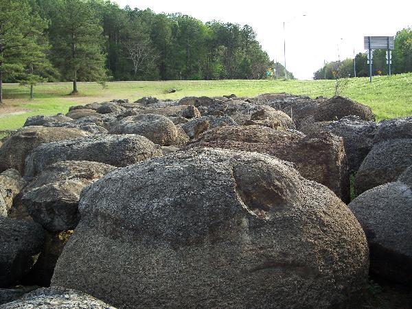
These giant boulders are known to geologists as concretions.
Concretion comes from the Latin root word con
“together” and cresco “to grow” Concretions
usually form in sedimentary rocks.
The concretion begins to form when a small amount of minerals fill
in the spaces between the grains of the sedimentary
rocks—usually before the sedimentary rock has even finished
hardening. Think of the minerals like a glue, holding grains of
sand together. Very often, this mineral cement is harder than the
sedimentary rock it surrounds. The concretions can be any shape,
but most often they are round or slightly ovoid (egg shaped).
To log this cache:
1) email us and explain how you know which type of concretion is
found at this location.
Optional--You are welcome to post a photo of yourself or your gps
taken at the site.
There are two main types of concretions: a) concentric and b)
pervasive. The concentric type grow in layers from the inside out,
often forming spectacular patterns. These tend to look like the
familiar gumballs of your youth. An example of this type would be
the beautiful “Thunder Eggs” that are the official
mineral of Oregon.

The pervasive type glues the sediments together from the outside
in, or all at once. These have the appearance of a
“snowball” (or other shape) made of tightly packed
sandstone, siltstone, or shale. Those three rock types are the most
likely to form concretions. This type most often includes
fossils.
Concretions can form around a fossil initially, and smaller
concretions are sometimes broken open to look for fossils.

photo credit
Do not damage the boulders to collect fossils!
Best access and parking is on the S Frontage Road. To reach the
location, take exit 152 off I-20/59 and head south to the frontage
road.
The boulders originally come from the Bashi Formation of the
Wilcox Group, which is exposed across most of the Gulf Coast coal
region. In Mississippi, the lower units in the Wilcox Group include
the silt, clay, sand, and lignite beds of the Nanafalia Formation
and the Tuscahoma Formation. The Bashi Formation is a glauconite
and fossil bearing sand, rich in fossiliferous concretions. It
separates the lignite-bearing Tuscahoma from the overlying shale
bearing Hatchetigbee Formation (Williamson, 1976; Bicker, 1969;
Dockery, 1996).
The Bashi Formation was deposited during a marine transgression
(rise in sea level) that was part of a larger sequence of cyclical
changes in sea level. According to Danehy, Wilf, and Little, the
contact between the Tuscahoma and Bashi Formations is marked by a
regional unconformity that extends from western Alabama to the
eastern region of Mississippi.
The local Bashi has two main divisions; a lowstand unit and the
upper transgressive marine unit. Bashti
divisions

The 3-meter thick lowstand unit is the lowest Bashi sediment in
Mississippi. It contains many fossils not found elsewhere in the
U.S. The upper transgression marine sedimentary rocks is made of
sands containing the mineral glauconite and many fossiliferous
boulders, in a layer slightly more than 1 meter in thickness.
Glauconite is considered an indicator of marine depostion with a
slow rate of accumlation along a continental shelf.
The Mt. Barton section of the Wilcox Group is an outlier of the
Tallahatta Cuesta, a prominent cuesta along the eastern flank of
the Mississippi Embayment that extends from southern Alabama to
north-central Mississippi. Mississippi
Embayment
Cuesta is the term for ridges formed by gently tilted sedimentary
rock layers. Cuesta comes from the Spanish word for slope. The
slope of the two sides of the cuesta ridges are different. The
escarpment where the rock layers are exposed on their side is
steeper, while the more gentle slope on the other side is called a
dip slope. cuestra
SOURCES & Links of Interest:
Blog on concretions
Thunder
Egg page
GSA
abstract on Calcite cementation in sandstone More on the
Bashti
Mozley, P.S., 1996, The internal structure of carbonate
concretions: A critical evaluation of the concentric model of
concretion growth: Sedimentary Geology: v. 103, p. 85-91.