Multicatxé "Camprodon"
Us proposem una tranquil·la passejada per Camprodon. Amb un cens de 2.000 habitants, és el municipi amb més extensió de tota la Vall. Està situat a una alçada de 940 metres per sobre el nivell del mar, enclavat a la carena pirinenca, amb un clima fred a l’hivern i suau a l’estiu.
Les coordenades d’on es troba el catxé final s´hi fan constar amb sis incògnites, que designem amb les lletres (A), (B), (C), (D), (E) i (F). A mesura que aneu fent el recorregut (per l’ordre que us proposem o seguint-ne un altre que us convingui més) es tracta, simplement, que aneu substituint cada lletra pel valor corresponent.
Desitgem que, durant la recerca d’aquest multicatxé, gaudiu del passeig per aquesta vila tan bonica i amb tanta història!
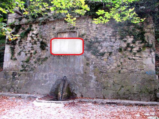
1) Mare de la Font (Waypoint 01) – N 42º 18.557 E 002º 21.967
En el terme municipal de Camprodon es fusionen dos rius, el Ter i el Ritort. Aquest fet excepcional el converteix en un indret ple de fonts. En total se n´hi compten una quinzena, repartides dintre i fora del nucli urbà. Una d’elles és l’anomenada Mare de la Font, a on uns versos del poeta Jacint Verdaguer decoren aquest broll natural d’aigua.
El nombre de vegades que la lletra M apareix en aquest poema, us proporcionarà el valor (E).
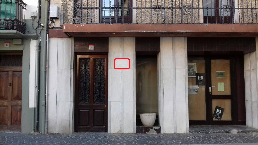
2) Plaça d’Espanya (Waypoint 02) – N 42º 18.699 E 002º 21.919
En aquest espai de forma irregular hi trobareu la Casa de la Vila, mostra del gòtic civil català. Per la seva singularitat, compta amb una reproducció al Poble Espanyol de Barcelona.
A una casa de la mateixa plaça hi va néixer el cèlebre compositor Isaac Albéniz. A la placa commemorativa situada a la façana, hi ha inscrita una data. La segona xifra de l’any que hi consta, és el valor (A).
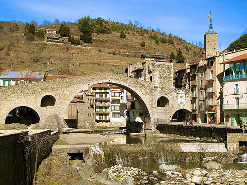
3) El Pont Nou (Waypoint 03) – N 42º 18.767 E 002º 21.896
Situat al bell mig de la població i construït el segle XII sobre el riu Ter. En un dels seus extrems s’alça la Porta de la Cerdanya, que donava entrada a la vila.
A la portalada hi ha inscripcions de la seva reforma. Una d’elles es troba a uns 8 metres d’alçada, a una llosa quadrada de pedra amb l’escut de Camprodon d’uns 40 cm. de costat situada a l’esquerra de torre. A sota de l’escut hi consta un any. De les quatre xifres, sumeu només les dues últimes i obtindreu el valor (D).
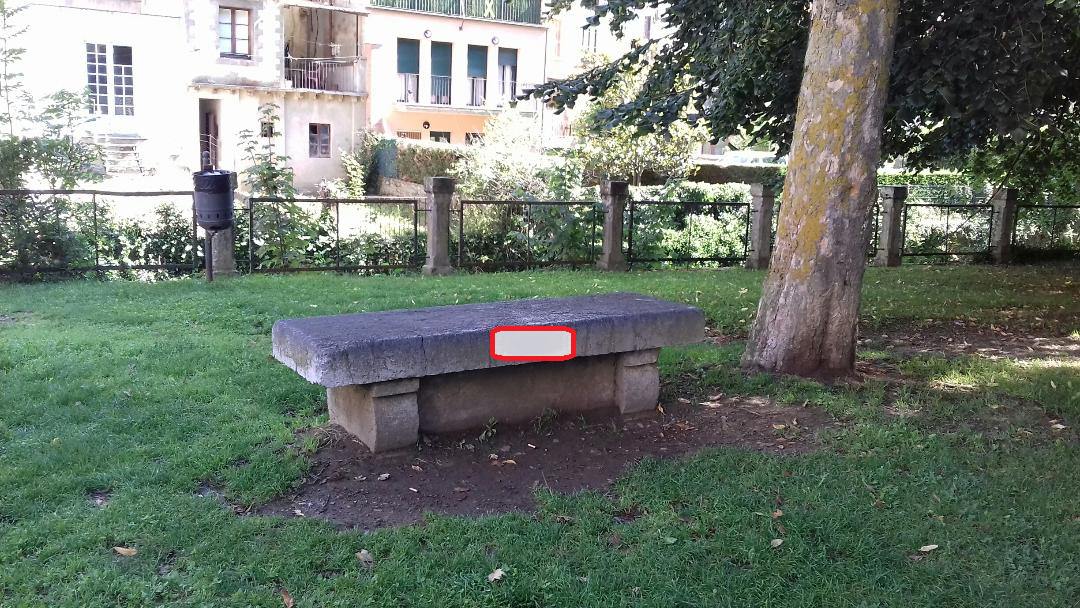
4) El passeig de la Font Nova (Waypoint 04) – N 42º 18.785 E 002º 22.096
Remodelat a la segona meitat del segle XIX, s’hi van ubicar les primeres residències d’estiuejants. Al final del passeig una font i un bust del Dr. Robert recorden la persona que impulsà l’activitat turística de la zona.
Al primer banc de pedra que hi ha al passeig, hi consta inscrit un any. La primera de les quatre xifres és el valor (C).
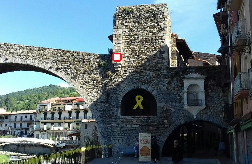
5) El Monestir de Sant Pere (Waypoint 05) – N 42º 18.860 E 002º 22.151
Construït sobre una planta de creu llatina reforçada per tres arcs amb l’absis central i el cimbori octogonal on descansa la torre del campanar de planta quadrada. Va ser fundat a mitjans del segle X pel comte Guifré de Besalú i regit pels monjos benedictins fins al 1835.
A sobre la portalada principal hi ha un rosetó de forma circular. El nombre de barrots de ferro disposats horitzontalment us proporcionarà el valor (B).

6) El passeig Maristany (Waypoint 06) – N 42º 18.940 E 002º 21.713
Urbanitzat els anys vint del segle passat i fet expressament amb les mateixes mesures i característiques que el passeig de Gràcia de Barcelona, està envoltat de torres i mansions per a l’estiueig. Durant un breu període fou punt de trobada del Govern de la República en haver-hi la residència familiar del seu president, el Dr. Negrín.
Des de la rotonda a on us trobeu, disposeu d’una bona perspectiva sobre una part del passeig. Si comptabilitzeu el nombre de fanals que hi ha a l’interior de la rotonda, obtindreu el valor (F).
Comprovació: A+B+C+D+E+F = 26
Les coordenades finals són:
N 42º 18.ABC
E 002º 21.DEF
Multicache "Camprodon"
We offer you a quiet ride for Camprodon. With a 2000 population census, the town is spread over the entire valley. Located at an altitude of 940 meters above sea level, nestled in the Pyrenees ridge, has a cold winter and mild summer.
The final coordinates of where the cache is, are obtained by having the values of six unknowns, which designates the letters (A) (B) (C) (D) (E) and (F). As you make the trip (in the order that we propose or by another one that suits you) is simply that you replace each letter by its corresponding value.
We want, while doing this multicache, you enjoy the walk through this beautiful town with so much history!
1) Mare de la Font (Waypoint 01) – N 42º 18.557 E 002º 21.967
In the township of Camprodon merge two rivers: Ter and Ritort. This makes it a unique place full of fountains. In total there are fifteen, spread within and outside the town. One is called “Lady of the Fountain”, where some verses of the poet Verdaguer decorate this natural water springs.
The number of times the letter M appears in this great poem will give the value (E).
2) Spain square (Waypoint 02) – N 42º 18.699 E 002º 21.919
In this irregular space, you’ll find the Town Hall, showing the Catalan civil gothic. For its uniqueness, it has a play at Poble Espanyol in Barcelona. In a house in the same square was born the famous composer Isaac Albéniz. In the commemorative plaque located on the facade, there is a date inscribed.
The second figure of the year there is presented, is the value (A).
3) Pont nou (Waypoint 03) – N 42º 18.767 E 002º 21.896
In the heart of the town and built in the twelfth century on the River Ter. At one end, it stands the Gate of Cerdanya, which gave entrance to the town.
At its portal there are inscriptions of its reform. One of them is located at a height of 8 meters, in a square slab of stone (side of 40 cm) with the shield of Camprodon, on the left side of the tower. Below the shield, there is a year. From the four digits, you just have to add the last two digits and get the value (D).
4) Font Nova walk (Waypoint 04) – N 42º 18.785 E 002º 22.096
Remodeling in the second half of the nineteenth century, housed the first of summer residences. At the end of a spring tour and a bust of Dr. Robert remember the person who promoted the tourism of the area.
In the first stone bench, there is registered a year. The first digit is the value (C).
5) Monastery of St. Pere (Waypoint 05) – N 42º 18.860 E 002º 22.151
Built on a latin cross plan with three arches reinforced by the central apse and the dome rests on an octagonal bell tower square. It was founded in the mid-tenth century by count Wilfred of Besalú and run by Benedictine monks until 1835.
Above the main doorway is a circular piece. The number of iron bars arranged horizontally will give you the value (B).
6) Maristany walk (Waypoint 06) – N 42º 18.940 E 002º 21.713
Built in the twenties of last century and made expressly with the same measures and characteristics of Passeig de Gràcia in Barcelona, is surrounded by houses and mansions for the summer. For a brief period was the meeting point of the Government of the second spanish Republic there in the family home of its president, Dr. Negrin.
From the roundabout where you are, you have a good perspective on a part of the walk. If you count the number of streetlights that are inside the roundabout, you’ll get the value (F).
Check: A+B+C+D+E+F = 26
The final coordinates are:
N 42º 18.ABC
E 002º 21.DEF