Glacial Grooves EarthCache
-
Difficulty:
-

-
Terrain:
-

Size:  (not chosen)
Please note Use of geocaching.com services is subject to the terms and conditions
in our disclaimer.
Houghton Hilltop Glacial Striations
Short Description:
Houghton’s hilltops are a good place to find glacial striations where rocks in glaciers left their mark on the basalt outcrops. On this hilltop, under a large survey maker, you will see how sediment mixed in with moving glacial ice cut grooves, scars, and scratches into the bedrock. (The owner of this cache is a participant in the Michigan Teaching Excellence Program (MITEP) through Michigan Technological University, which teams with science teachers to improve science teaching and learning.)
Cache Coordinates: N 47°6.829 W 88°33.898
Access Information:
Materials: GPS, compass, magnifying lens, field notebook
Parking/Distance/Footwear: When you navigate to the site coordinates, you will find ample parking on widened shoulders of the road. You will see a triangular survey marker on a hilltop about 200 yards away where you will find glacial striations cut into exposed basalt. Wear shoes/boots suitable for walking through long field grass to reach the hilltop.
Essential Lesson:
- Glaciers are made of ice with rocks trapped in the ice.
- Rocks embedded in the bottom of the glacier scrape along exposed bedrock and leave behind line-shaped groove, scar, and scratch marks. (We call these grooves, scars, and scratches "glacial striations.")
- The direction of the glacial striations gives us the direction the glacier flowed and other information as well.
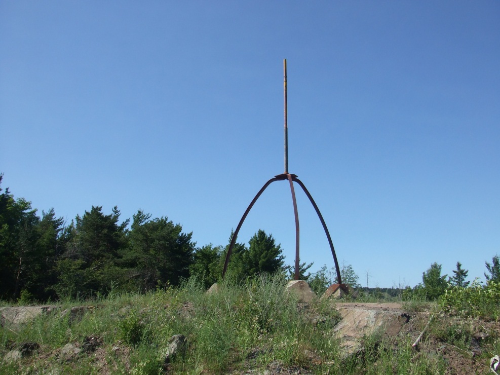
Figure 1. Survey Marker located near the glacial grooves. Photograph by D. Youngren
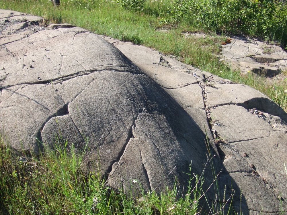
Figure 2. Glacial Groove. Photograph by D. Youngren
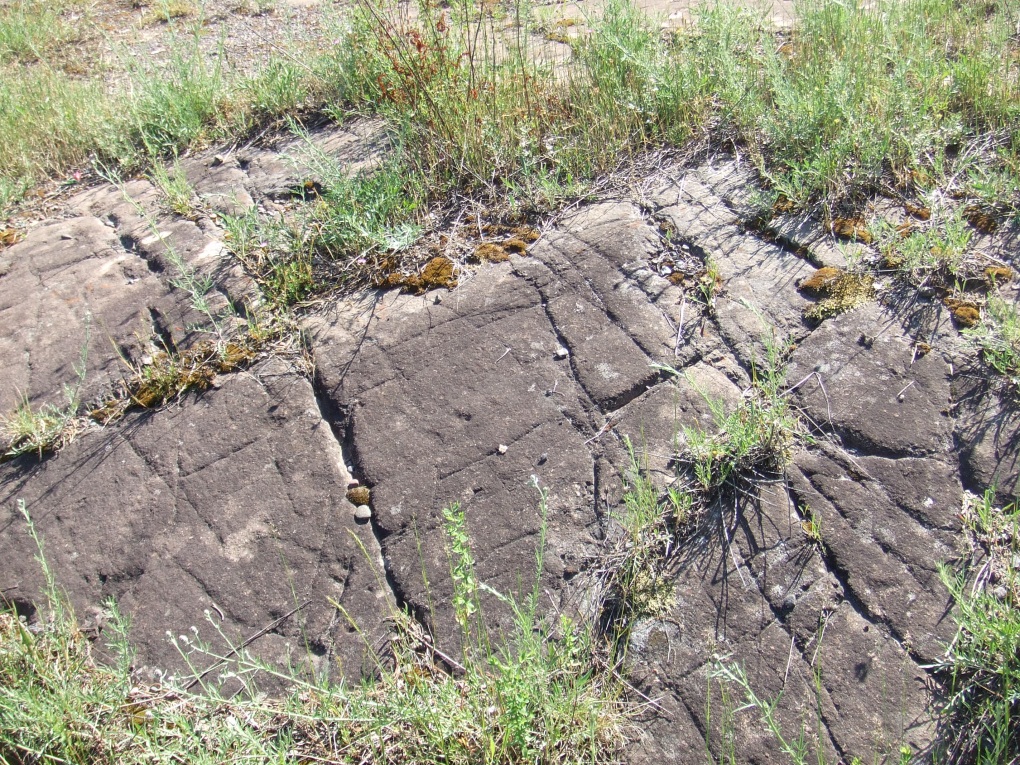
Figure 3. Glacial scars and scratches. Photograph by D. Youngren
Long Description:
The complex geological history of the Keweenaw began over a billion years ago in the Precambrian Era during the formation of a Midcontinent Rift System. Since then, volcanic lava flows, faulting, erosion, sedimentation, and glaciation have transformed the Keweenaw into what we see now. The lava flows that hardened into the basalt are part of what today we call the Portage Lake Volcanics Series. Each new lava flow created a new layer of basalt rock. In between lava flow events, there were periods of erosion and deposition creating layers of sandstones and conglomerates, as well as some shales.
However, the actual shaping of the Keweenaw as we know it today was not accomplished until late in the Pleistocene by glaciation—only yesterday in geologic time. The Pleistocene is the time period that spanned from 2.6 million to 11,700 years ago, spanning the world's recent period of repeated glaciations. During this rather recent event, vast sheets of ice in the form of glaciers gathered in the snowfields of Canada and slowly moved to cover the northern half of the North American continent and bury the Earth’s surface with an average depth of over 6,000 feet of ice.
Fallen snow over many years—recent layers compressing older layers into large, thickened ice masses—makes glaciers. Due to sheer mass, glaciers are unique in their ability to move. They move like very slow flowing rivers. Some glaciers are football field size, while others grow to be over fifty miles long.
When moving, glaciers are huge geological bulldozers. They move and pick up rocks as they flow across the land. The glaciers carry these rocks with them and scrape the rocks beneath them (bedrock) with the rocks mixed in their ice. The large rocks in the glaciers can cut striations in the rocks beneath the glacier, and the small rocks in the glacier can smooth and polish the bedrock.
Presently, glaciers occupy about 10 percent of the world's total land area, with most located in Polar Regions like Antarctica and Greenland. In the United States, glaciers cover over 30,000 square miles, with most of the glaciers located in Alaska. If all land ice melted, the sea level would rise approximately 230 feet worldwide.
Glacial ice often appears blue because it has become very dense. Years of compression gradually make the ice denser over time, forcing out the tiny air pockets between crystals. When glacier ice becomes extremely dense, the ice absorbs all other colors in the spectrum and reflects primarily blue, which is what we see. When glacier ice is white, that usually means that there are many tiny air bubbles still in the ice.
With Earth now nearing the end of an interglacial, which is a period of warmer climate within an ice age, the normal climate variation cycle means that another Ice Age is due in a few thousand years. However, the Earth’s warming (Greenhouse Effect) may delay the onset of another glacial era, but scientists still have many questions to answer about climate change. Although glaciers change very slowly over long periods, they may provide important global climate change signals.
Before Logging Your Visit:
Glacier striations help to determine glacier movement. Glaciers that covered Michigan came from Canada. Use your compass to determine glacial direction as you observe the grooves, scars, and scratches that we call glacial striations. Ask yourself:
- Are there multiple striations only in the same direction?
- Are striations all parallel and linear?
- Are striations all the same size?
- Are there smooth areas on the rock where there are no striations?
Logging Questions:
To obtain credit for visiting this EarthCache, please email me your response to the following question:
- What direction or directions did you get for your compass readings?
- What did you observe about the glacial striations that you found (number, size, distance, position, depth)?
- Using your observations and compass readings, what other information do you think the glacial striations tell in addition to the direction that the glacier or glacier were moving? (Hint: Number and size of the glaciers.)
_________________________________________________________________
Earth Science Literacy Big Ideas:
Big Idea 2. Earth is 4.6 billion years old.
2.1 Earth’s rocks and other materials provide a record of its history. Earth scientists use the structure, sequence, and properties of rocks, sediments, and fossils to reconstruct events in Earth’s history. Decay rates of radioactive elements are the primary means of obtaining numerical ages of rocks and organic remains. Understanding geologic processes active in the modern world is crucial to interpreting Earth’s past.
Comment: This EarthCache provides evidence that rocks record Earth’s history. The rocks on this Houghton hilltop retain the striations created by glaciers that moved over the area in the past.
_________________________________________________________________
Common Earth Science Misconception:
Glaciers are only moving ice masses (with little to no concept of sediment transport).
Comment: Glacial striations are evidence that glaciers are not just moving ice masses, but glaciers also transport abrading sediment.
_________________________________________________________________
Key Earth Science/Geological Words:
Basalt: The most common extrusive igneous rock that is fine-grained because the molten basalt cools rapidly at the Earth's surface.
Glaciers: When fallen snow remains in one location over many years and compresses into large, thickened ice masses, glaciers develop that are capable of moving due to their sheer mass. Glaciers flow like very slow rivers. Some glaciers are as small as football fields, while others grow to be over fifty miles long.
Glacial Striation: Grooves, scars, and scratches carved into bedrock by rocks frozen into the bed of a moving glacier. Striations are generally multiple, parallel, and linear.
Ice Age: A cold period marked by extensive glaciation with some episodes of relative warmth. When the cool temperatures endured for extended periods, polar ice advanced into lower latitudes.
Interglacial: A period of warmer climate within an ice age.
________________________________________________________________
References:
Huber, N. K. (1975). The geologic story of Isle Royale National Park. Retrieved from http://www.minsocam.org/MSA/collectors_corner/usgs/b1309.htm#pyro
Mineralogical Society of America. (2012). Collector’s corner. Retrieved from http://www.minsocam.org/msa/collectors_corner/vft/mi2a.htm
U.S. Department of the Interior/U.S. Geological Survey. (2012). Glaciers and icecaps: Storehouses of freshwater. Retrieved from http://ga.water.usgs.gov/edu/earthglacier.html
U.S. Department of the Interior/U.S. Geological Survey. (2012). Glossary of glacier terminology. Retrieved from http://pubs.usgs.gov/of/2004/1216/s/s.html
USGS/Cascades Volcano Observatory. (2001). Glaciers and glacier features. . Retrieved from http://vulcan.wr.usgs.gov/Volcanoes/Rainier/Publications/PNNPFA-Driedger86/glacier_features.html
Additional Hints
(No hints available.)