TFGT: First Flights Traditional Geocache
-
Difficulty:
-

-
Terrain:
-
Size:  (small)
Please note Use of geocaching.com services is subject to the terms and conditions
in our disclaimer.
Anyone can claim this cache, but to be eligible for the Taking Flight Geo Tag, please look at the laminated shorebird identification card included inside the cache and do the following: Name the types of birds found on Anna Maria Island (from those listed on the card – lots of birds may visit but we need to verify that you saw the card in the cache!) and tell us what is one thing you can do to help nesting shorebirds?
Anna Maria Island is a barrier island along the coast of Manatee County. It’s sandy shores dip into the Gulf of Mexico and are considered to be some of the best beaches in the world. Three communities: Holmes Beach, Anna Maria, and Bradenton Beach, have year round residents and also attract thousands of beach-loving tourists each year. But the “natives” here are not local Florida residents; they are the thousands of shorebirds that flock to the same beaches each year to lay their eggs and raise their families.

Birds on the beach. Photo by Lou Newman
The Anna Maria Island Turtle Watch & Shorebird Monitoring website explains that shorebirds, or waders, are not simply birds found at the shore, but are the families of plovers, sandpipers and related forms. Most of these birds can be found along shorelines, especially in migration, but they are also found inland, upland, and even on arctic tundra or at sea. Each year, Anna Maria Island has a variety of shorebirds that visit its shore including six species that nest on the beaches and over ten species which just enjoy feeding and loafing (a birding term for resting) on the Manatee County shoreline.
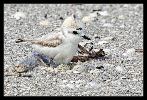
Can you find the eggs? Photo by Lou Newman
Many of Florida’s beach-nesting birds are now listed as threatened or endangered. Unlike other bird species, the numbers have not decreased because of hunting but rather these birds have lost their prime nesting habitat due to increased development and human activity on the barrier island beaches they call home. Shorebirds lay eggs that are very well-camouflaged in a nest that would make most mothers cringe – just a shallow depression in the sand. The camouflage and understated nest are an excellent adaptive strategy, however, making the nest site nearly invisible. The problem is, they are not only invisible to predators that might like to eat the eggs but also to beach-goers who want to tan, play, dig, and walk across the sand. The shorebirds are also skittish; any disturbance can cause them to abandon their nests, leaving the eggs and chicks exposed to the harsh summer sun, weather, and predators. Even though it is illegal to harass or hurt the threatened and endangered species, each year many nests are destroyed by unaware beach visitors. The good news is, there are lots of things you can do to help especially when you visit Florida’s beaches.
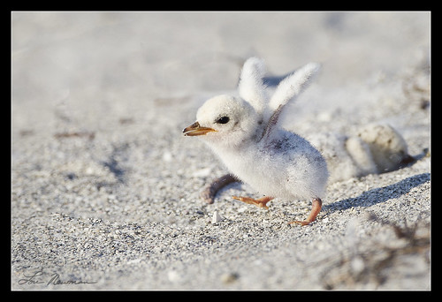
Even the chicks blend in! Photo by Lou Newman
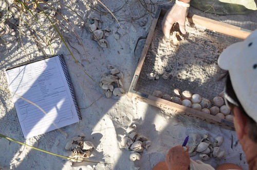
Counting turtle eggs and protecting the beaches' shorebirds. Photo courtesy Anna Maria Island Turtle Watch
Anyone can claim this cache, but to be eligible for the Taking Flight Geo Tag, please look at the laminated shorebird identification card included inside the cache and do the following: Name the types of birds found on Anna Maria Island (from those listed on the card – lots of birds may visit but we need to verify that you saw the card in the cache!) and tell us what is one thing you can do to help nesting shorebirds?
Visit the sites along the Taking Flight GeoTour (TFGT) and learn about Manatee County’s wild spaces and the amazing feathered friends that live in them. Along the way, you will be challenged to become a citizen scientist, a preserve ranger, a detective, a historian, and of course an excellent geocacher in order to find all of the caches in the trail. Caches are located in birding “hot spots” throughout Manatee County’s publicly accessible conservation preserves. Each one highlights a specific bird species or aspect of bird life providing you with opportunities to learn more about these creatures and what we can do to help them survive. Caches also focus on protecting the region's waterways, bays, and natural watersheds, and habitat areas for many of our area’s feathered fliers.
The Taking Flight GeoTour includes 20 caches within Manatee County. A custom Taking Flight Geo Tour trackable geo tag will be awarded for locating at least 12 TFGT caches. To be eligible for the tag, geocachers must download a passport from the TFGT Website or pick one up at the Manatee County Natural Parks & Natural Resources Department office at GT Bray Park 5502 33 rd Ave. Dr. W., Bradenton, FL., Monday through Friday, 9 a.m. to 4 p.m. Geocachers must log at least 12 finds, answer the question from each cache on their passport, and complete any additional requirements for specific caches (such as posting photos for earth caches). After finding a minimum of 12 caches, participants can have their passports validated in person or via mail at the Manatee County Natural Parks & Natural Resources Department office at GT Bray Park 5502 33 rd Ave. Dr. W., Bradenton, FL 34209, Monday through Friday, 9 a.m. to 4 p.m. News and updates on tag availability and validation hours can be found online at the Parks & Natural Resources Department's website.
Thank you for assisting with the Taking Flight GeoTour:
Additional Hints
(Decrypt)
guebhtu gur envyvat