 Attention :
 une earthcache est une
cache virtuelle (pas de boîte) : pour la loguer comme "Found it" vous devez obtenir les réponses à mes questions, me les envoyer par
mon profil et attendre ma validation.
Be carefull : an earthcache is a
virtual one (no box) and in order to log "Found it" you have to send to me (
my profil) the answers about my questions and to wait my email back to allow you to log.
 HISTOIRE GEOLOGIQUE DU LIEU :
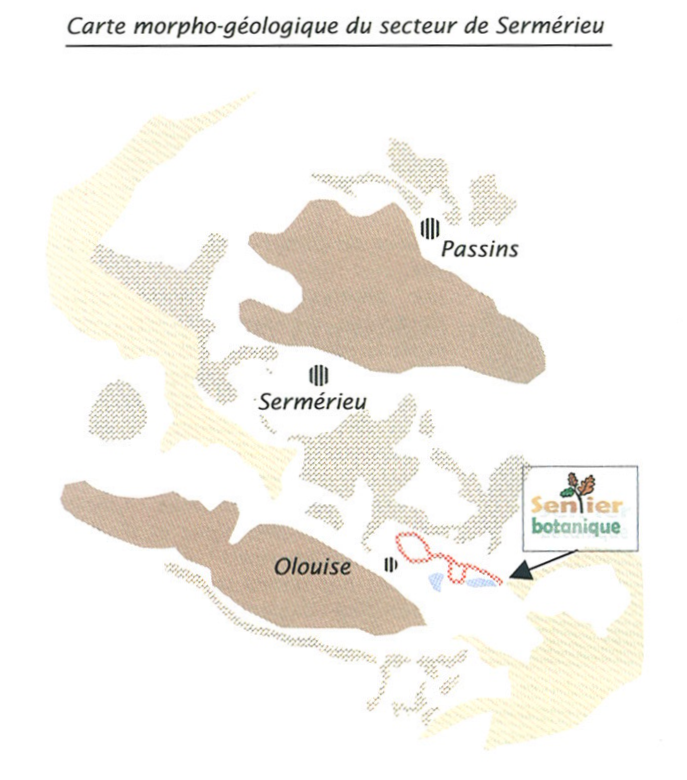
Nous sommes situés sur un éperon calcaire, en bordure est du plateau crémolan. Cette roche s’est formée il y a 140 millions d’années dans la mer jurassique.
Il y a quelques 25 millions d’années le sol s’est effondré, permettant à la mer d’occuper toute la façade ouest des Alpes naissantes et jusqu’à Vienne en Autriche : le sillon alpin. Bien entendu, elle s’est également installée autour des molards de la région.
L’érosion des jeunes Alpes voisines fournit alors aux cours d’eau des quantités énormes de sédiments, sables et graviers, acheminés jusqu’à la mer. Les graviers, plus lourds, se déposent les premiers dans le delta, les sables étant emportés plus au large.
Leur épaisseur atteint 1000 m en Bas Dauphiné et 800 m dans le plateau suisse !
Ces matériaux, cimentés ensuite plus ou moins solidement par du calcaire, ont formé des roches appelées « poudingues » (formation de cailloux et graviers grossiers) et « molasse » (formation sableuse).
Il y a 5 millions d’années, sous la poussée du plissement alpin alors à son paroxysme, la molasse commence à émerger et forme des collines qui viennent s’imbriquer dans les formations calcaires, comme en face de nous à la borne 9.
Mais l’histoire ne s’arrête pas là. Pendant le dernier million d’années, 4 longues périodes glaciaires s’abattent sur la région, qui est entièrement prise sous la glace.
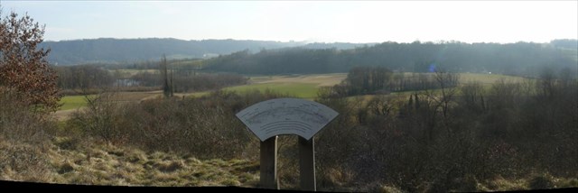
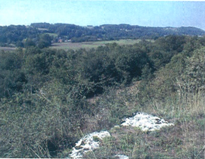
Il y a 15000 ans à peine, le glacier s’avançait encore jusqu’au talus sableux que vous gravissez en venant à la borne 9 (sa moraine frontale). Il avait comblé d’alluvions toute la plaine d’Olouise qui s’étend à vos pieds.
Quant à la couche d’alluvions sur la colline, elle provient de l’abandon de celles-ci lors de la fonte du glacier.
La petite dépression marécageuse que l’on devine dans la plaine, près d’Olouise, est probablement due à une « lentille de glace » qui, tardant à fondre, a empêché tout comblement par ces alluvions. Lors de la fonte, cette lentille a engendré un lac, devenu tourbière du fait du comblement progressif par les végétaux aquatiques.
 GEOLOGICAL HISTORY OF THIS AREA
We are located on a calcareous area, in Crémieu’s limestone pavement. This rock was formed 140 million years ago in the Jurassic sea.
25 million years ago the ground broke down, allowing the sea to occupy the entire western side of the recent Alps to Vienna, Austria. Of course, it also settled around the “molards” of this region.
The erosion of the recent Alps provides to the rivers enormous quantities of sediments, sands and gravels, conveyed to the sea. The gravels, heavier, settle first in the delta, sands being carried away.
Their thickness reaches 1000 m in this area and 800 m in the Swiss pavement! These aggregates, cemented then more or less firmly by limestone, formed rocks called “conglomerates” (stones and quite big gravels) and “molasse” (sandy formation).
5 million years ago, with the pressure of the Alps, the molasse starts to emerge and forms hills which come to be imbricated in the formations limestones, like here in front of us at the 9th panel. But the history does not stop there. During the last million years, 4 long ice ages set on the area, which is entirely taken covered by the ice.
15000 years ago, the glacier still advanced to the sandy slope which you climbed while coming to the 9th panel (its terminal “moraine”). It had filled with alluvial material all the plain of Olouise which extends to your feet. The layer of alluvial material on the hill comes from the the thaw of the glacier.
The small marshy depression in the plain, close to Olouise, is probably due to an “ice lens” which, being long in melting, prevented any filling by these sedmients. During the thraw of this lens of ice, it generated a lake, became peatland because of progressive filling by the watery plants.
QUESTIONS pour valider la earthcache / QUESTIONS to valid this earthcache :
Merci de m'envoyer par
mon profil les réponses à ces questions avant de loguer "Found it" :
- Qu'est-ce qu'un molard ?
- Quand sont ils apparus dans la région (en millions d'années indiqués sur la borne) ?
- et donc à quelle période géologique (lue sur la borne) ?
Vous pouvez joindre une photo de la vue (avec vous dessus éventuellement) si vous le souhaitez (pas obligatoire). Réponse sous 1 jour ou 2 en général).
Please send to me by
my profile the answers before to log "Found it" (in english or french) :
- What is a "molard" ?
- When did they appear in this region (million years written on the 9th panel) ?
- and what was the geological age (written on the panel) ?
It would be friendly if you join a picture of the view from the 9th panel (with you if you want) but it is not compulsory. I generally send back the agrement by email to log "Found it" in 1 or 2 days.