
La Earthcache / The Earthcache
L'extrême nord-ouest du département de Vaucluse est occupé par le « massif » de Bollène/Uchaux, ensemble de collines de faible altitude orientées ouest-est et situées à l'est de la vallée du Rhône.
Ce massif présente une complexité stratigraphique à l'origine d'un structure superficielle riche en contraste, avec toutes les nuances possibles de sol (blanc, rouge, jaune,...).
C'est cet ensemble pédologique particulier que nous allons étudier à proximité du lac Vert, au cœur de ce massif.
► Le sol - quelques définitions pédologiques
Le sol (dont l'étude se nomme la pédologie) est le point de rencontre du vivant et du minéral à la limite Lithosphère-Biosphère-Atmosphère.
Il provient de la décomposition et de l’altération des roches par l’action de l’eau, de l’air et des êtres vivants. Leurs formations et leurs évolutions dépendent ainsi de différents facteurs intimement liés : nature et âge du matériau géologique parental, climat, relief, activité biologique.
Voici quelques éléments caractérisant l'étude d'un sol :
- Roche mère : roche ou sous-sol rocheux sous-jacente dont la dégradation est généralement à l'origine de la fraction minérale du sol.
- Horizon : le sol présente deux fractions (organiques et minérales) qui se mélangent à des degrés divers selon la profondeur et donnent différents niveaux parallèles à la surface au sol, appelées horizons, d’abord humifères, puis minéraux. Ils sont généralement désignés par une lettre et ses dérivés (O ; A/A1 ; E ; FE ; B ; S / Sal ; C ; R).
- Granulométrie : La classification de la fraction minérale se fait principalement sur le diamètre de ces éléments (granulométrie). On peut utiliser pour cela le diagramme de texture, présentant 3 pôles : sableux, limoneux, argileux et présentant toutes les combinaisons possibles.
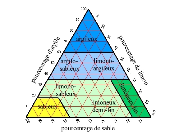
La granulométrie joue un rôle primordiale dans l’existence de lacs et retenues d'eau.
Plus le sol est fin (importante proportion d'argiles), plus celui-ci est imperméable, entraînant une conservation de l'eau météoritique en surface.
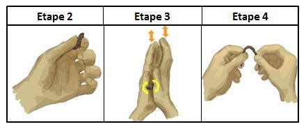
Parmi les tests de granulométrie, l'un des plus simples et plus ludiques est le test du Boudin :
1/ Prenez un peu de terre entre vos doigts, mouillez-la légèrement et malaxez-la pour en faire une boule. Si elle colle fortement sans trop salir les doigts, elle est riche en argile et en limon fin.
2/ Écrasez la terre entre le pouce et l’index. Si vous ressentez un aspect soyeux, c’est le signe de la présence de limons fins et d’argile. En revanche si vous sentez entre vos doigts des petits grains rugueux plus ou moins gros qui grattent et crissent, il s’agit de sables.
3/ Maintenant, roulez la boule pour en faire un boudin entre vos deux paumes. Si vous ne parvenez pas à l’affiner sans le casser (boudin grossier), votre sol est à tendance sableuse. Si vous pouvez faire un boudin plus fin (2 à 7 mm) sans le casser, il s’agit d’un sol limoneux.
4/ Si vous parvenez aisément à faire un boudin de moins de 2 mm et que vous pouvez le courber sans le casser, votre sol est à dominante argileuse.
► La Roche mère du « massif » de Bollène/Uchaux
La formation géologique à l'origine de la couche superficielle pédologique est la couche stratigraphie "C5-C4b. Santonien et Coniacien supérieur.".
Il s'agit exclusivement de formations sédimentaires détritiques, de nature complexe : sables blancs avec intercalations de grès ferrugineux, argiles gypseuses et ligniteuses.
Il présente surtout la particularité d'avoir de puissants bancs d'argiles pliocènes très purs (marnes plaisanciennes), qui ont été exploités dans des carrières environnantes.
Cette série argileuse d'origine lacustre se retrouve dans la zone du lac Vert, et va fortement influencer la composition du sol du pourtour du lac, donnant deux types principaux de sols.
► Un sol fersiallitique
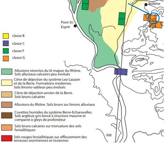
Une carte pédologique générale donne, dans la région sud-est de Bollène, un sol brun calcaire sur troncature de sols fersiallitiques.
Au niveau du lac Vert, l'altération du sol a mis à nu la partie fersiallitique, un fersialsol appelé aussi sols rouges méditerranéens, les fameuses "terra rosea".
Ces sols fersiallitiques se développent surtout dans les régions méditerranéennes et sont le résultat d'une association forte et stable entre des colloïdes argileux (montmorillonite) et des oxydes de fer.
Ce sont des sols rouges très riches en oxydes de fer et en oxydes d'alumine et se forment sous couvert forestier.
Les sols fersiallitiques présentent plusieurs horizons caractéristiques :
- Un horizon organique supérieur O/A peu épais :
Cette horizon constitué de débris végétaux morts plus ou moins transformés en conditions aérobies est peu épais du fait du faible apport de matière organique (forêts de résineux) et d'un climat peu propice à la dégradation de cette matière organique.
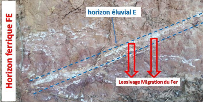
- Un horizon ferrique FE prédominant :
C'est un horizon oxydant avec accumulation de fer dominant et mélange avec l'argile.
Cet horizon présente une couleur rouge profonde, dont la couleur varie selon la concentration en fer.
- Des petits horizons éluviaux E :
ils correspondent à des horizons appauvris en fer par lixiviation (lessivage par les eaux des minéraux de fer qui vont alors migrés dans les couches inférieurs).
Il existe différents types d'horizon E, mais dans le cas des sols ferrallitiques, c'est le type "Ea" blanchi qui prédomine, dont l'appauvrissement est intense, voire total.
► Un Réductisol - Stagnogley
Le sol du lac Vert est impacté par les variations importantes des niveaux d'eau du lac Vert selon les saisons. La partie inférieur du sol fersiallitique se trouve alors régulièrement sous le niveau du lac, provoquant un milieu réducteur.
Cette saturation du sol en eau va provoquer la réduction (passage du fer de sa forme oxydé Fe3+ à Fe2+), entraînant sa dissolution et une déferrification du sol dont l'horizon devient un horizon G albique, de couleur blanc.
The extreme north-west of the department of Vaucluse is occupied by the "massive" Bollène / Uchaux, set of low-lying hills facing west-east and located east of the Rhone Valley.
This massif presents a stratigraphic complexity at the origin of a superficial structure rich in contrast, with all the possible nuances of soil (white, red, yellow, ...).
It is this particular soil set that we will study near the Green Lake, in the heart of this massif.
► The soil - some soil definitions
The soil (the study of which is called pedology) is the meeting point of the living and the mineral at the limit Lithosphere-Biosphere-Atmosphere.
It comes from the decomposition and alteration of rocks by the action of water, air and living things. Their formations and their evolutions thus depend on various intimately related factors: nature and age of the parental geological material, climate, relief, biological activity.
Here are some elements characterizing the study of a soil:
- Mother rock: rock or underlying bedrock, the degradation of which is generally the source of the mineral fraction of the soil.
- Horizon: the soil has two fractions (organic and mineral) that mix to varying degrees depending on the depth and give different levels parallel to the surface on the ground, called horizons, first humus, then minerals. They are usually designated by a letter and its derivatives (O; A / A1; E; FE; B; S / Sal; C; R).
- Granulometry: The classification of the mineral fraction is mainly done on the diameter of these elements (granulometry). The texture diagram can be used for this, with 3 poles: sandy, loamy, clay and all possible combinations.
Particle size plays a vital role in the existence of lakes and reservoirs.
The thinner the soil (large proportion of clays), the more it is impermeable, leading to the conservation of meteoritic water on the surface.
Among the granulometry tests, one of the simplest and most fun is the Boudin test:
1 / Take a little dirt between your fingers, wet it slightly and knead it to make a ball. If it sticks strongly without dirtying the fingers, it is rich in clay and fine silt.
2 / Crush the earth with your thumb and forefinger. If you feel silky, it is the sign of the presence of fine silt and clay. On the other hand if you feel between your fingers small rough grains larger or smaller that scratch and scream, it is sands.
3 / Now roll the ball to make a pudding between your two palms. If you can not refine it without breaking it (coarse pudding), your soil is sandy. If you can make a thinner rod (2 to 7 mm) without breaking it, it is a loamy soil.
4 / If you can easily make a roll of less than 2 mm and you can bend it without breaking it, your soil is predominantly clay.
► The mother rock of the Bollène / Uchaux massif
The geological formation at the origin of the pedological surface layer is the "C5-C4b, Santonian and Upper Coniacian" stratigraphy layer.
It is exclusively detrital sedimentary formations, of a complex nature: white sands with intercalations of ferruginous sandstones, gypsum and lignite clays.
It presents especially the peculiarity of having powerful schools of very pure Pliocene clay (marne plaisanciennes), which were exploited in surrounding quarries.
This lacustrine clay series is found in the Lac Vert area and will strongly influence the soil composition around the lake, resulting in two main types of soils.
► A fersiallitic soil
A general soil map gives, in the south-east region of Bollène, a calcareous brown soil on truncation of fersiallitic soils.
At the level of the Green Lake, the alteration of the soil exposed the fersiallitic part, a fersialsol called also red soils Mediterranean, the famous "terra rosea".
These fersiallitic soils develop mainly in the Mediterranean regions and are the result of a strong and stable association between clay colloids (montmorillonite) and iron oxides.
These are red soils very rich in iron oxides and alumina oxides and form under forest cover.
The fersiallitic soils have several characteristic horizons:
- A higher organic horizon O / A thin:
This horizon consisting of dead plant debris more or less transformed under aerobic conditions is thin because of the low organic matter intake (softwood forest) and a climate that is not conducive to the degradation of this organic matter.
- A predominant ferric FE horizon:
It is an oxidizing horizon with dominant iron accumulation and mixing with clay. This horizon has a red color deep, whose color varies according to the concentration of iron.
- Small eluvial horizons E:
they correspond to horizons depleted of iron by leaching (water leaching of iron minerals which will then migrate to the lower layers). There are different types of E horizon, but in the case of ferrallitic soils, it is the bleached "Ea" type that predominates, the depletion of which is intense, even total.
► A Reductisol - Stagnogley
The soil of Green Lake is impacted by significant variations in Lake Green water levels depending on the season. The lower part of the fersiallitic soil is then regularly below the lake level, causing a reducing medium.
This saturation of the soil with water will cause the reduction (passage of iron from its oxidized form Fe3 + to Fe2 +), resulting in its dissolution and deferrification of the soil whose horizon becomes an albic horizon G, white color.
► Sources bibliographiques / Bibliographical sources
Les Questions / The Questions
La lecture attentive du descriptif de la cache, ainsi qu'une observation des éléments de terrain et un peu de déduction sont normalement suffisants pour répondre aux questions de cette EarthCache.
A careful reading of the description of the cache, as well as observation of terrain features and some deduction is usually sufficient to answer questions of this EarthCache.
Questions pour valider :"Balade pédologique au Lac Vert"
Questions to validate: "Soil walk at Lac Vert"
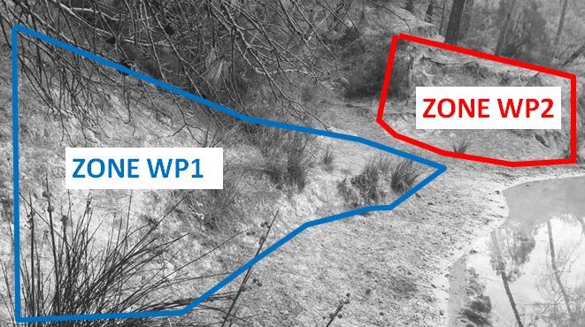
Vous voici au bord du Lac Vert ; les deux zones (WP1 et WP2) sont distantes de quelques dizaines de mètres (voir photo Zone_ensemble_WP1_WP2).
Here you are at the edge of Lac Vert; the two zones (WP1 and WP2) are separated by a few tens of meters (see photo Zone_ensemble_WP1_WP2).
Point 1 : N 44° 15.932 E 004° 45.911
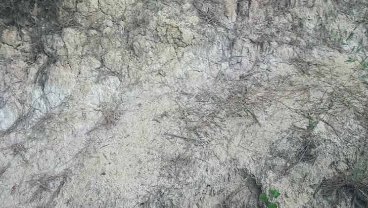
Vous voici sur les berges du Lac Vert (voir la zone WP1 de la photo Zone_ensemble_WP1_WP2).
Here you are on the banks of Green Lake (see the WP1 zone of the photo Zone_ensemble_WP1_WP2).
- Question 1 : En réalisant le test du boudin (voir descriptif) sur un échantillon de sol et en utilisant le diagramme de texture, déterminer sa texture. Celle-ci explique t-elle la présence du lac Vert ?
- Question 1 : By performing the flange test (see description) on a soil sample and using the texture diagram, determine its texture. Does this explain the presence of Green Lake?
- Question 2 : Décrivez la couleur du sol du WP1. Comment appelle t-on ce type de sol et nommez son horizon caractéristique ?
- Question 2 : Describe the color of the WP1 soil. What is the name of this type of soil and what is its characteristic horizon?
Point 2 : N 44° 15.930 E 004° 45.921
Remonter de quelques mètres maintenant vers la zone WP2. Vous vous trouvez devant un affleurement présentant une belle coupe de sol (voir la zone sous la photo WP2_Large).
Go up a few meters now to the WP2 area. You are in front of an outcrop with a nice cut of ground (see the area under the photo WP2_Large).
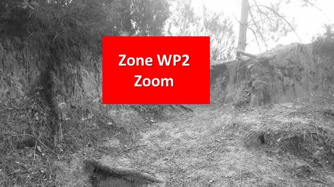
Approchez vous de cette zone rouge WP2 et regarder les différents ensemble de la photo WP2_Zoom.
Get close to this red WP2 area and look at the different sets of the WP2_Zoom photo.
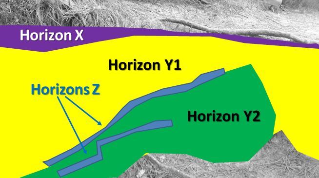
- Question 3 : A partir de la photo WP2_Zoom, identifier les noms et lettres des horizons X, Y et Z ?
- Question 3 : From the photo WP2_Zoom, identify the names and letters of horizons X, Y and Z?
- Question 4 : Expliquer l'origine de la couleur des horizons Z, et des conséquences que cela présente pour la différenciation des horizons Y1 et Y2.
- Question 4 : Explain the origin of the color of the Z horizons, and the consequences this has for the differentiation of the horizons Y1 and Y2.
Vous pouvez vous loguer sans attendre notre confirmation,
mais vous devez nous envoyer les réponses en même temps soit par mail via notre profil (
fafahakkai), soit via la messagerie geocaching.com (Message Center).
S'il y a des problèmes avec vos réponses nous vous en ferons part.
Les logs enregistrés sans réponses seront supprimés.Une photo de vous ou de votre GPS depuis les berges avec le lac Vert en arrière plan sera la bienvenue, mais n'est pas obligatoire.
You can log this cache without waiting for our confirmation, but you must send us the answers at the same time, by e-mail via our profile (fafahakkai) or by the system of Message Center of geocaching.com.
If there is a problem with your answers we will notify you. The logs recorded without answers will be deleted.
A photo of you or your GPS from the banks with the Green Lake in the background will be welcome, but not mandatory.
Rappel concernant les « Earthcaches »: Il n'y a pas de conteneur à rechercher ni de logbook à renseigner. Il suffit de se rendre sur les lieux, de répondre aux questions ci-dessus et de nous renvoyer les réponses.
Reminder concerning "Earthcaches": there is neither a container to look for nor a logbook to sign. One need only go to the location, answer to the differents questions and send us the answers.