World's End EarthCache
-
Difficulty:
-

-
Terrain:
-
Size:  (other)
Please note Use of geocaching.com services is subject to the terms and conditions
in our disclaimer.
Horton Plains National Park is a protected area in the central highlands of Sri Lanka and is covered by montane grassland and cloud forest. This plateau at an altitude of 2,100–2,300 metres is rich in biodiversity and many species found here are endemic to the region.

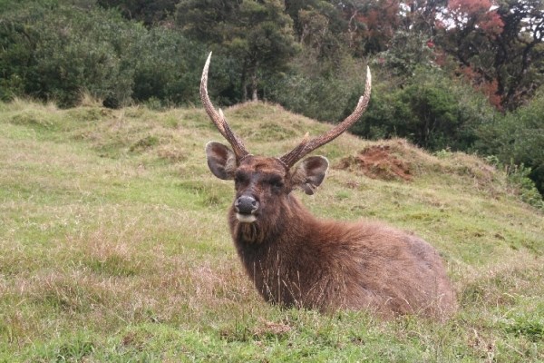
 The Horton Plains are the headwaters of three major Sri Lankan rivers, the Mahaweli, Kelani, and Walawe. In Sinhala the plains are known as Maha Eliya Plains. This region was designated a national park in 1988. It is situated 32 kilometres from Nuwara Eliya. Stone tools dating back to Balangoda culture have been found here. The plains' vegetation is grasslands interspersed with montane forest, and includes many endemic woody plants. Large herds of Sri Lankan Sambar Deer feature as typical mammals, and the park is also an Important Bird Area with many species not only endemic to Sri Lanka but restricted to the Horton Plains. Forest dieback is one of the major threats to the park and some studies suggest that it is caused by a natural phenomenon. The sheer precipice of World's End and Baker's Falls are among the tourist attractions of the park.
You can park your car in the neighbourhood of the information desk N6 48.126 E80 48.432.
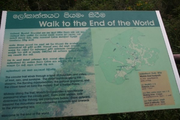
You can find the answers in the information office or at the information pannels along the trail. If you like, you can walk the trail via Mini World’s End at N6 47.046 E80 47.912 to World’s End at N6 46.842 E80 47.649 and back via Baker’s Falls at N6 47.552 E80 47.371. The trail is about 9 km long. Send me an e-mail with answers to the following questions:
1.) Watch at the stones of World’s End. What do you see? Color, size, form, solidity.
2.) Tell us how high you estimate the plains comes out of the land below.
3.) From which layer of stones is World’s end made?
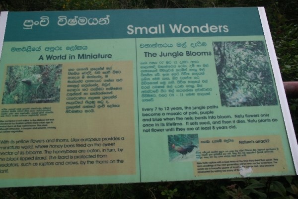
4.) Which bird eats the Nelu fruits and what is special about the bird.
5.) After you've got log permission, post a photo with your log, showing you or your GPS at World’s End, Mini Worlds’s End or Baker’s Falls (optional).
Please, log only after you have got log permission!
Happy caching!
Physical features
Horton Plains is located on the southern plateau of the central highlands of Sri Lanka. The peaks of Kirigalpotta (2,389 metres) and Thotapolakanda (2,357 metres), the second and the third highest of Sri Lanka, are situated to the west and north respectively. The rocks found in the park belong to the Archaean age and belong to the high series of the Precambrian era and are made up of Khondalites, Charnockites and granitic gneisses. The soil type is of the red-yellow podsolic group and the surface layer is covered with decayed organic matter.
The mean annual rainfall is greater than 2,000 millimetres. Frequent cloudy cover limits the amount of sunlight that is available to plants. The mean annual temperature is 13 °C but the temperature varies considerably during the course of a day, reaching as high as 27 °C during the day time, and dipping as low as 5 °C at night. During the southwest Monsoon season, the wind speed sometimes reaches gale force. Although some rain falls throughout the year, a dry season occurs from January-March. The ground frost is common in February. Mist can persist in the most of the day during the wet season. Many pools and waterfalls can be seen in the park, and Horton Plains is considered the most important watershed in Sri Lanka.
History
The original name of the national park is Maha Eliya Thenna. But in the British period the park was renamed after Sir Robert Wilmot-Horton, the British governor of Ceylon from 1831 to 1837, who travelled to the area to meet the Ratemahatmaya of Sabaragamuwa in 1836. Stone tools dating back to Balangoda culture have been found here. The local population who resided in the lowlands ascended the mountains to mine gems, extract iron ore, construct irrigational canal and fell trees for timber.
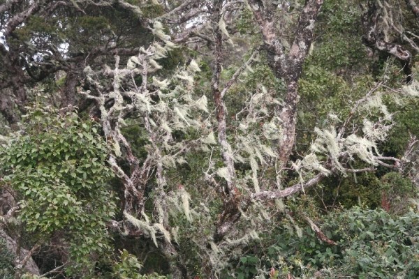
The vegetation of the park is classified into two distinctive groups, 2,000 hectares of montane grasslands and 1,160 hectares of subtropical montane evergreen forests. Tree trunks and branches are ornamented with many species of ferns, Lycopodium, lichens, and orchids. Old man's beard hanging from branches adds to the beauty of the forests. About 16 of the orchid species being endemic.
Every 7 to 12 years, the jungle paths become a mosaic of pink, purple and blue when the Nelu bursts into bloom. Nelu flowers only once in its lifetime. It sets seed, and then it dies. Nelu plants do not flower until they are at least 8 years old.
The vertebrate fauna of the region includes 24 species of mammals, 87 species of birds, nine species of reptiles and eight species of amphibians. The Sri Lankan Elephant disappeared from the region in the 1940s at the latest. At present, the largest and the most commonly seen mammal is the Sambar Deer.
In geography and geology, a cliff is a significant vertical, or near vertical, rock exposure. Cliffs are formed as erosion landforms due to the processes of erosion and weathering that produce them. Cliffs are common on coasts, in mountainous areas, escarpments and along rivers. Cliffs are usually formed by rock that is resistant to erosion and weathering. Sedimentary rocks are most likely to form sandstone, limestone, chalk, and dolomite. Igneous rocks, such as granite and basalt also often form cliffs.
An escarpment (or scarp) is a type of cliff, formed by the movement of a geologic fault, or a landslide.
Most cliffs have some form of scree slope at their base. In arid areas or under high cliffs, these are generally exposed jumbles of fallen rock. In areas of higher moisture, a soil slope may obscure the talus. Many cliffs also feature tributary waterfalls or rock shelters. Sometimes a cliff peters out at the end of a ridge, with tea tables or other types of rock columns remaining.
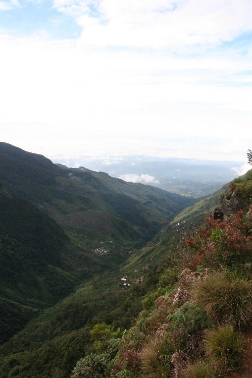
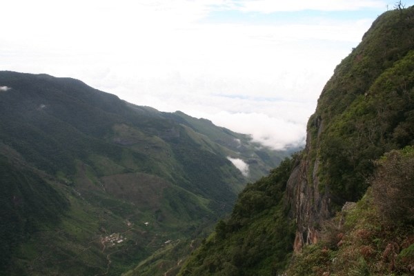
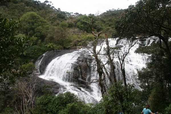
World's End is a sheer precipice with a 870 m drop. It is situated at the southern boundary of the park. Another cliff known as the Mini World's End of 270 m is located not far from World's End. Baker's Falls, a waterfall formed by Belihul Oya, a tributary of the Walawe River is named after Sir Samuel Baker, a hunter and explorer who attempted to establish a European agricultural settlement at Nuwara Eliya. The falls are 20 metres high. Slab Rock Falls is another well known waterfall in the plains.
Additional Hints
(No hints available.)