[ENG]
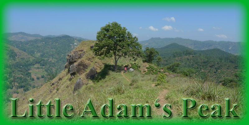
Little Adam's Peak is 1,141 meters high pyramidal rock in southeast part of Sri Lanka's highlands. It is named after famous holly mountain Adam's Peak, because of the similar shape. Climbing to the top of its little brother is much easier and quiet. On the given coordinates, you can find beautiful view to the endless valley, tea plants or waterfalls.
Southeast highlands is very various area. Extensive erosion in this area has worn down the ridges and deposited rich soil for agriculture downstream. In the southeast, a red, lateritic soil covers relatively level ground that is studded with bare, monolithic hills. The transition from the plain to the Central Highlands is abrupt in the southeast, and the mountains appear to rise up like a wall.
City of Ella is nice small town in embouchure of the Ella gap valley. Near this town you can find many caves, waterfalls, or rocks so we can rate it as geologically very important place.
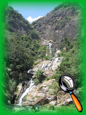
The Ravana Falls are ranked as one of the widest falls in the country. This waterfall measures approximately 25 m (82 ft) in high and cascade from an oval-shaped concave rock outcrop. During the local wet season, the waterfall turns into what is said to resemble an areca flower with withering petals. But this is not the case in the dry season, where the flow of water reduces dramatically. The falls form part of the Ravana Ella Wildlife Sanctuary. The falls have been named after the legendary hindu character Ravana, which is connected to the famous Indian epic, the Ramayana. According to legend, it is said that Ravana (who was the king of Sri Lanka at the time) had kidnapped princess Sita, and had hidden her in the caves behind this waterfall, now simply known as the Ravana Ella Cave. At the time, the cave was surrounded with thick forests in the midst of wilderness. It is also believed that Rama’s queen bathed in a pool that accumulated the water falling from this waterfall.
Wateralls are typically formed by a river, which flows over a large step in the rocks that may have been formed by a fault line. As it increases its velocity at the edge of the waterfall, it plucks material from the riverbed. This causes the waterfall to carve deeper into the bed and to recede upstream. Often over time, the waterfall will recede back to form a canyon or gorge downstream as it recedes upstream, and it will carve deeper into the ridge above it.
Often, the rock stratum just below the more resistant shelf will be of a softer type, meaning that undercutting due to splashback will occur here to form a shallow cave-like formation known as a rock shelter or plunge pool under and behind the waterfall. Eventually, the outcropping, more resistant cap rock will collapse under pressure to add blocks of rock to the base of the waterfall. These blocks of rock are then broken down into smaller boulders by attrition as they collide with each other, and they also erode the base of the waterfall by abrasion, creating a deep plunge pool or gorge.
Streams become wider and shallower just above waterfalls due to flowing over the rock shelf, and there is usually a deep pool just below the waterfall because of the kinetic energy of the water hitting the bottom. Waterfalls normally form in a rocky area due to erosion. After a long period of being fully formed, the water falling off the ledge will retreat, causing a horizontal pit parallel to the waterfall wall. Eventually, as the pit grows deeper, the waterfall collapses.
Waterfalls can occur along the edge of a glacial trough, whereby a stream or river flowing into a glacier continues to flow into a valley after the glacier has receded or melted. The large waterfalls in Yosemite Valley are examples of this phenomenon. The rivers are flowing from hanging valleys.
Types of waterfalls
Block: Water descends from a relatively wide stream or river.
Cascade: Water descends a series of rock steps.
Cataract: A large, powerful waterfall.
Fanny: Water spreads horizontally as it descends while remaining in contact with bedrock.
Horsetail: Descending water maintains some contact with bedrock.
Plunge: Water descends vertically, losing contact with the bedrock surface.
Trip to the cache. Course to the cache goes through wonderful tea plantation. You can start in waypoint "START". It is a beginning of the way into plantation. In waypoint "GATE", you can find green gate, turn to the right to this gate. In waypoint "STAIR" you can decide - direct way up the stairs is shorter, but more difficult. Left way is longer, but easier. My recommendation is to go one way up the stairs and back the way round.
HOW TO LOG THIS CACHE?
1. On given coordinates turn to the west and make picture of yourself with the GPS device and the great object over the valley. Join this picture to your log. This condition is optional.
2. What is the name of the mountain, you have just photoed?
3. On the picture in listing (or in southwest direction from given coordinates), you can see the waterfalls. Which type of waterfalls you can see?
... Send me the answers on e-mail in my profil.
I wish you a nice trip.
Log without invitation please.
This is earthcache with no box on given coordinates. For more information follow this link: www.earthcache.org
[CZE]
Cesta ke keši je proti výstupu na Adam's peak velmi jednoduchý. Na procházku vyjdete v zatácce silnice smerem k waypointu "START". Poté jdete cestou mezi cajovými plantážemi až uvidíte bránu a waypoint "GATE". Za ní pravdepodobne narazíte na milého prodavace šperku ze semínek, který vám ochotne vysvetlí další cestu. Nicméne, není kde zabloudit. Cesta vede až k waypointu "STAIR", kde se mužete rozhodnout. Po schodech je cesta kratší, ale prudší, cesta vlevo je delší, ale má menší sklon. Pokud se vracíte, tak je ideální variantou cesta tam po schodech a zpet delší cestou.
JAK SI KEŠ ZALOGOVAT?
1. Na zadaných souradnicích se otocte smerem na západ a vyfotte se s GPS a velkým objektem, který se nachází naproti pres údolí. Obrázek pripojte k logu. Tato podmínka je dobrovolná.
2. Jak se jmenuje hora, která se s vámi nachází na práve vytvorené fotografii?
3. Jihozápadním smerem možná zahlédnete vodopády. Pokud ne, podívejte se na obrázek vodopádu v listingu. Jakého typu tyto vodopády jsou?
... Odpovedi mi pošlete na e-mail v profilu.
Logujte prosím bez vyzvání. Kdyby bylo něco špatně, tak se ozvu.
Preji Vám pekný výlet