Cave Spring, Virginia encompasses 11.8 square miles and has a population of 25,789 people. Officially it’s not a town, it is a Magisterial District of Roanoke County. The name of this sizeable area is derived from one relatively small, but enticing triangular hole in a rock outcropping that thousands drive by each day and might not even notice. Not even many Roanokers know where the area's titular cave spring actually is. It is located just off Brambleton Avenue (Rt. 221). The history of the Cave Spring can be found at the "Welcome to Cave Spring" Geocache. This Earthcache will focus on the geological formation of this landmark.

Introduction
First of all, thanks to Tony and Teresa for their permission to post this Earthcache. The Cave Spring is on private property, but is visible from a public road, so no trespassing is necessary to enjoy its beauty. The property includes the spring, an historic bunkhouse and a renovated log cabin. Please show your appreciation for the landowner allowing this Earthcache to be placed by not passing the fence that plainly separates the private property from Old Cave Spring Road. Parking is available at the Waypoints below. THIS HAS BECOME A VERY HIGH TRAFFIC AREA, SO EXERCISE CAUTION WHEN CROSSING ROADS.

Cave Formation
All caves are not created equal - in fact no two are exactly alike. There are different kinds (ice, karst, volcanic tubes, sea caves) and they are formed by many different processes (chemical, erosion, wave action, subsidence, dissolution, lava floes). No one is able to accurately predict how long it takes a cave to form. There are just too many variables, and often these are unobservable since they are underground. Forces such as streams, wind, lava, acid rain or ocean waves over time can carve out spaces large enough for us to walk in. Cave Spring, as the name connotes, serves as the discharge point for an unseen, underground river. If you were to look around this area, you would find the closest creek is on the opposite side of Old Cave Spring Road, but its elevation is lower than the elevation of the Cave Spring. So this creek can't be the source of the spring – in fact, the spring actually feeds this creek. Therefore the recharge zone of the spring must be underground, invisible to us. But how and why does it exit at the spring?
The Appalachians
The Roanoke Valley is located in a band of geology which spans the western third of the Commonwealth called the Blue Ridge Mountain Province. This physiographic Province is part of the Appalachian Mountain range and extends from Pennsylvania to Georgia. The Blue Ridge contains the highest mountains in eastern North America. The three primary rock types in this Province are limestone, dolomite and shale.
There are few surface streams in the limestone valleys of the Blue Ridge Province as runoff from mountain slopes disappears into the subsurface upon contact with the karst bedrock. Water then flows underground, emerging at springs on the valley floor. So what in the world does "karst" mean?
Karst Topography
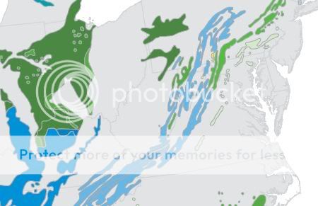
Not all bedrock is solid. Karst is a German word derived from the Slovenian "Kras" which means bare, stony ground. It was originally used to describe a limestone plateau near Trieste, Slovenia. Now the term means any landscape with distinctive landforms and hydrology shaped by the dissolution of a layer or layers of soluble bedrock, usually carbonate rock such as limestone (calcium carbonate, CaCO3) or dolomite (calcium magnesium carbonate, CaMg(CO3)2). Both of these rock types are slightly soluble in water. Karst terrain is characterized by springs, caves, sinkholes, and aquifers that are highly productive but also vulnerable to contamination.
About 20 percent of the land surface in the U.S. is classified as karst. Other parts of the world with large areas of karst include China, Europe, the Caribbean, and Australia. In the United States, about 40% of the ground water used for drinking comes from karst aquifers. In western Virginia, karst terrain occurs along slopes and in valleys between mountain ridges.
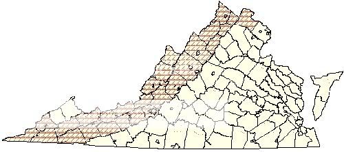
Virgina Counties with Karst Topography
 Some karst formations (called speleothems) can be the very dramatic stalactites, stalagmites, drapery, straws and flowstone that are showcased in publicly accessible cavern systems along Interstate 81. Most caves are formed in limestone karst.
Common speleothems
Some karst formations (called speleothems) can be the very dramatic stalactites, stalagmites, drapery, straws and flowstone that are showcased in publicly accessible cavern systems along Interstate 81. Most caves are formed in limestone karst.
Common speleothems

The Process
Rain can collect carbon dioxide as it falls to the earth forming a weak carbonic acid (acid rain). The addition of carbon dioxide greatly increases the solubility of the water. Once rain has been absorbed by the soil it picks up additional carbon dioxide from decaying organic matter and plants. In this way the water passing through the soil and into the underlying rocks has the capacity to dissolve limestone and dolomite. The ground water enters cracks and fractures in these layered rocks and begins to dissolve it. When the water reaches an underlying layer of impenetrable rock, the water moves sideways, forming an underground river.
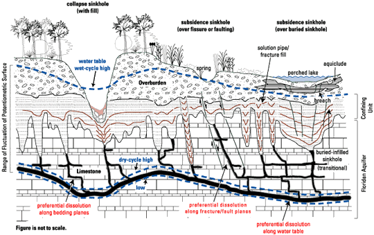
Subterranean water follows difficult to predict paths, bearing little relationship to surface topography. Depending on the acidity of the water and the path it takes through the rock, a cave may form. If it finds an exit from the rock, this is called a spring. Most karst groundwater returns to the surface at springs near streams and rivers like this. Depending on the constancy of the water source (rainfall or snowmelt that infiltrates the earth), a spring may be ephemeral (intermittent) or perennial (continuous).
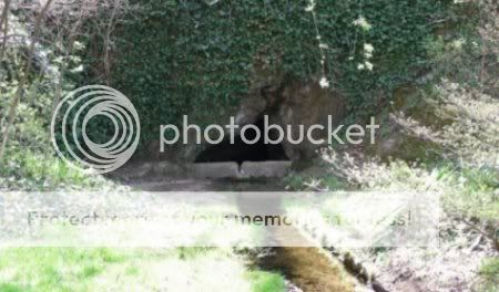
Cave Spring
Cave Spring is also a tributary of a creek. This area has many springs that can be observed from public roads. If this spring was in a depression or sink hole, it might have formed a pool.
Spring House with a pool

But Cave Spring flows under the road into Mud Lick Creek, which in turn flows north into the Roanoke River near the Norwich neighborhood of Roanoke City. Roanoke River eventually flows into Albemarle Sound and the Outer Banks of North Carolina. That's a journey of 400 miles and 1,093 vertical feet for this spring water!
Discharge from Cave Spring toward Mud Lick Creek

What you'll see depends on the time of year you visit. In the summer the view of the cave entrance is obscured by wisteria vines, but is still partially visible. Spring is a beautiful time to visit as the landowner has accented the landscape around the entrance with various blooming flora. If you visit the cache in December, you may see a very special extraterrestrial visitor at the cave entrance who has appeared annually in recent years.
The Inside Scoop
The water level in the cave only averages 16.5" deep. It would have almost no depth if left to flow naturally across the impenetrable bedrock below. But it has been modified by a manmade concrete dam across the cave entrance. Photos show this was in place as early as the 1960's and I theorize that the dam and the groove in the middle of it were installed to channel the water into a flume shape for easier bottling. When the water is low, it flows through an opening under this dam into a concrete channel crossing the lawn of the property to contain flooding. The water's source in the earth keeps the water at a constant 55 °F all year long, so it feels cold in the summer and warm in the winter. Springs, including this one, provided refrigeration for perishables in pioneer times.
Immediately beyond the entrance that you can see, the A-shaped ceiling quickly diminishes at a steady slope on the left, and by means of a large boulder-shaped formation on the right. The scalloped-shaped patterns on the slopes of the ceiling surfaces indicate the downward path of the water in the dissolution process.
Cave Spring Ceiling
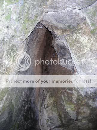
There is some staining on the ceiling of the cave which is evidence of the introduction of some surface water which has left iron and other mineral deposits from the soil behind. As the photos show, there are no dramatic stalactites and stalagmites, but there are small white calcite deposits visible both inside and outside the entrance. The approximate depth of the cave is only 20 feet and the source of water is a hole at the remote tip of this conical volume. Beyond this hole, its source remains unknown.
Inside View at Water Level

Some of the cave's inhabitants have included bats, trout (introduced by a landowner until the flood of 1985 released them), crayfish and even ducks. We once observed a crayfish inside the cave consuming the contents of a walnut that had sunk to the cave bottom. At least 8 bat species use the cave habitats throughout Virginia. Many species are known from only one or two caves.
To log this Earthcache as a find, please answer the following:
1. The cave entrance is a triangle. What are the approximate dimensions of each side of the triangle’s perimeter?
2. Is the spring ephemeral, or perennial?
3. What kind of stone do you think forms the structure of the cave?
4. Take a photo of yourself and/or your GPS from a safe location with the cave entrance visible anywhere in the background.
Optional bonus math question: If the mouth of the cave were measured as a flat plane, what type of triangle would it approximate?
E-mail the answers (Items 1-3 and optional bonus) to me and post the photo (Item 4) with your log. Do not log as a find until you have a photo ready to post. Failure to comply with these requirements will result in log deletion.
Now as you drive past the springs and sinkholes of Western Virginia, you can sing to the tune of “Personality” by Lloyd Price:
“’Cause you got - karst topography
Walk, on karst topography
Talk, with karst topography
Smile, at karst topography
Charm, that karst topography
Love, karst topography!
What more can I do?”
Or not...


Sources:
USGS Virginia Karst Project
Virginia Cave Board
Virginia Department of Conservation and Recreation
Ask.com