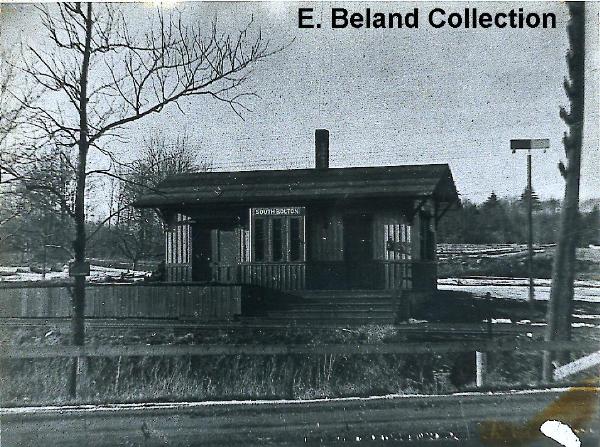
The cache is not at the above coordinates. Instead, this is the Pope Street station of the Central Mass Railroad, which would have been the next stop after the South Bolton Station if you were riding toward Boston on the Central Mass Railroad in the late 1800s – early 1900s. Sorry about all the mosquitos - please bring bug spray.
To find the cache, you must decipher a code.
While I was clearing the site for this geocache, I got caught on a thorn bush and uttered the following:
“$@_@#>()# and &!_#^>!&!”
Looking at it more closely, I realized this was a perfect clue for the cache.
The coordinates are at the center of some structural remains that we are pretty sure are part of the South Bolton Station. These are some concrete piers with metal rod and pipe sticking out of them. The cache is hidden about 10 meters to the southeast. Near there are 2 larger threaded rods with nuts on them.
It is probably OK to park at the nearby hotel offset south .021 and east .026 of the deciphered coordinates. From there, you are probably on the same line of sight as which the photo was taken. Notice that things have grown in slightly after 80 years.
You should be able to find a cleared trail and cleared area for where you need to go. No bushwacking is necessary. There is a bit of poison ivy in the area, so be on the alert. One vine was growing on the tree near the cache.
My old maps of the Central Mass railroad line had shown that a train station existed somewhere in the west corner of Hudson, right on the border of Berlin and Bolton. I had made small forays along the track there over the years with modest attempts to discover its true site. A couple of old photos teased me with just enough view to tell me the station existed, but not really pin down the street intersection it was near or the side of the tracks it rested. I finally got serious in searching for it the last few months. Also on the slate was a nearby trolley trestle, which elevated a Clinton-Hudson trolley over the Central Mass line, supposedly to keep it out of tax hungry Bolton. There is a photo of this trestle in Images of America – Hudson on page 46. For our search, we used current topographical and aerial photo maps, along with the 1870s series of Massachusetts town maps, and historic USGS series of maps. The excellent resources of the Northboro library and Goodnow library were called upon. Assistance was provided by other Central Mass RR buffs Nels Anderson, Jimi Smith, Mr. Edden and Trolley expert Ray Shoop. Penultimate breakthroughs were made with the help of the guys at the nearby Beatle III shop, which lead to the included photos of Mr. Ernie Beland.
This search was further complicated by:
The site being at the corner of 3 towns (which town was it really in?) so I was never really sure which map to expect to find it on.
Bolton had ceded this area of land to Hudson in 1868, giving it the name South Bolton.
Floating town borders between generations of maps
This area being the border of 2 counties; Worcester having been mapped in 1870, and Middlesex, mapped in 1875. I think the station was built in 1872 so it showed on neither map - c’mon, give me a break!
Multiple names for the region: South Bolton, Brown’s Corner, Stone’s Corner, will you make up your mind already?
On the 1870 Worcester county map of Bolton and Berlin, a nearby building was labeled “S. Bolton”, but it is not the station. Sam Bolton? Sally Bolton?
An adjacent street intersection has similar characteristics in the photos I had.
Some guy living at the other street intersection told me that he was sure his house was the old train station (WRONG BIG TIME!).
The giveaway in the first photo (1922) is the tree in the foreground. It must have been at least 30 years old then, and still stands today with the same boughs.