
Parkeren is mogelijk op / parking at: N51° 39.189 – E005°36.198
Net als onze andere Earthcache 'De Kooldert', gaat deze cache over het fenomeen de Peelrandbreuk, alleen nu vanuit een ander perspectief.
Like our other Eartcache 'De Kooldert', this cache is about the phenomenon the Peelrandbreuk, only this time from another point of view. For further explanation in English, please see below after the Dutch text.
********************************
Ligt de Kooldert achteraf in het rustige boerenlandschap, deze Stadweide is onderdeel van de entree van Uden vanuit het buitengebied. Ze laat ons elk seizoen weer een wisselend landschap zien en biedt ruimte voor recreatie en natuur in de bebouwde omgeving. Het is mooi om te zien hoe de natuur en bewoonde wereld in elkaar op kunnen gaan. De Stadsweide mag betreden worden en is toegankelijk via de op verschillende plekken aanwezige poortjes. Zoals altijd; heb respect voor de natuur en haar aanwezige elementen.
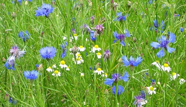
De Peelrandbreuk is de grootste aardkorstbreuk van ons land en loopt van Italië tot IJsland. Juist in en bij Uden komt de breuk dicht aan de oppervlakte, wat grondwater doet uittreden. Zo ook in deze Stadweide, waar de breuk bloot is gelegd, wat bloemrijke, natte vegetaties zal opleveren.
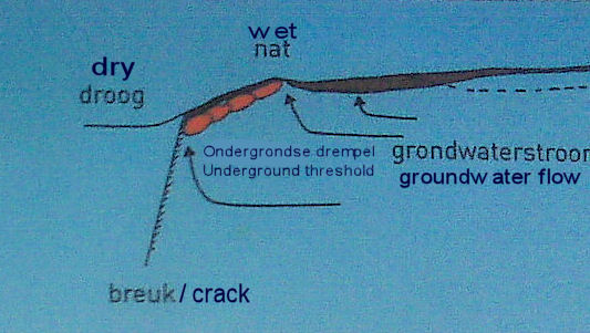
De breukrand waarop we hier staan is een ondergrondse drempel waar het naar het westen stromende grondwater overheen moet. Omdat het grondwater zeer ijzerrijk is vormt zich, wanneer het aan de oppervlakte komt roest op de drempel. Vaak is aan de vegetatie binnen enkele decimeters afstand duidelijk te zien waar de breuk ligt.
Om deze Earthcache te kunnen loggen verzoeken we je naar deze locatie te gaan om aldaar onderstaande 5 vragen te beantwoorden die op het informatiebord te vinden zijn en de opdracht uit te voeren.
- Door welke rivier is de Udense bodem tot 140.000 jaar geleden gevormd?
- Hoe noemt men de sikkelvormige zandduinen ook wel??
- Waardoor zijn de kiezelbanken veranderd in ondoordringbare en bikkelharde oerbanken?
- Waaruit bestaat de "horst" en waaruit de "slenk"?
- Welke wollige viervoeters zorgen in de zomer en het najaar voor het beheer van de Stadsweide?
- Maak een foto van jezelf en GPS met het lager gelegen gedeelte van deze Stadsweide op de achtergrond. Omdat deze Stadsweide recent aangelegd is, is het leuk om op de foto's de veranderingen te kunnen volgen door de jaren heen.
Stuur je antwoorden per e-mail naar ons toe en als je alle vragen goed beantwoord hebt en de foto bij je logje geplaatst hebt, zal je log blijven staan.
Veel cacheplezier!
Groene groetjes van het Stokstaart-team
Is De Kooldert situated remotely in the calm agricultural scenery, this city meadow is part of the entrance of Uden coming out of the outside area. Each season a changing landscape is shown and it offers space for recreation and nature in the cultivated surroundings. It is beautiful to observe how nature and inhabited world merge into each other. This city meadow can be entered and is accessible via on several spots present gates. Like always; respect mother nature and its present elements.
The Peelrandbreuk is the largest earth crust crack of our country and runs from Italy to Iceland. Exactly in and at Uden the crack comes to the surface, what makes the groundwater rise. Also in this city meadow where the crack has been laid bare, which will produce flowery, wet vegetation.
The crack edge on which we stand here, is an underground threshold -see 2nd image- where the to the west flowing groundwater must go across. When the groundwater comes to the surface, rust is formed because the groundwater is very rich in iron. Often the vegetation within some decimeters distance, clearly shows the presence of the crack.
To be able to log this Earthcace, go to this location and please answer below questions, which can be found on the present information board and carry out the task:
- By which river the Udense soil is formed 140.000 years ago?
- What is another name for the crescent-shaped sand dunes ("sikkelvormige zandduinen" )?
- Whereby are the shingle banks ("kiezelbanken" ) turned into impenetrable and unyielding primeval banks ("oerbanken")?
- What kind of sediment does the "horst" exist of and what kind of sand does the graben ("slenk") exist of?
- Which woolly quadrupeds take care of the landscape in Summer and Fall?
- Make a picture of yourself with GPS, with the lower part of the city meadow as background. Because this city meadow has recenlty been constructed it is nice to see the changes on the pictures through the coming years.
Please send your answer to us via e-mail and if all questions are correctly answered and you have placed your photo with your log, it will remain.
Lot of cache fun!
Greetings Stokstaart-team