Dronningstien Traditional Geocache
-
Difficulty:
-

-
Terrain:
-

Size:  (small)
Please note Use of geocaching.com services is subject to the terms and conditions
in our disclaimer.
Dronningstien (Queen's Trail)
Welcome to the island of Senja. Here you can feel like you are the King of the world! Or at least feel just like the Queen of Norway did in 2009 while hiking from the village of Skaland on Senja.
This cache is to mark a trail that seems to have become our Queen's favourite hike. The Norwegian Queen is a sporty lady who likes to spend time outdoors hiking and skiing. In 2009 she made a private visit to this place and hiked up to the top of the mountain named "Husfjellet" which gives you a magnificent view of the entire world (promise). Well, ok, at least a view of what seems like half of the island of Senja. You will be thoroughly impressed anyway, this I really do promise.
As she seemed to like this walk so much, people started to call this trail "Dronningstien" (the Queen's trail).
The use of this name was laughingly endorsed by the Queen herself during an official visit to the small church at the beginning of this trail, in 2011. And then she made another private visit in 2012. It seems like the trail truly deserves it's name.
* * * *
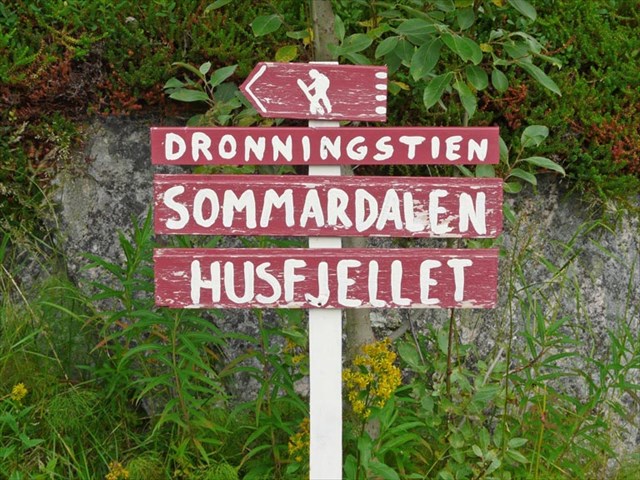
The trail starts at the church, look for a red handpainted wooden sign "Dronningstien".
Incidentally, this church deserves a cache of it's own, as this is the parish of the first ordained female priest in Norway.
The trail is 4km long, climbing from sea-level to 632 m. A small section at the beginning of the trail has a detour-loop where it is possible to use a mountain bike, but this is not recommendable. The rest of the trail is a fairly good trail with a few very marshy sections. You will probably use around 2 hours climbing up, 1.5 hours going down. See the enclosed track plot and height-profile plot.
The cache box is a lock&lock 600ml 12 x 8 x 6 cm transparent container.
My GPS was very jumpy at the top, use hint and spoiler pictures.
Please write your logs in english, so that other cachers from around the world can enjoy your description and hints for the trip. And most of all, please upload pictures from your trip.
Credit goes out to local enthusiast ME for the background info, and for helping to maintain this cache.
Additional Hints
(Decrypt)
Haqre ebpxf, arkg gb pyvss.