[DE:] (for english Version see below)
Eine Reise in die Vergangenheit.....
Stell dir vor, wir befinden uns in einer Zeit vor dem 1. Mai 2000, vor der Abschaltung der künstlichen Verschlechterung des GPS-Signals.
Oder noch früher, vor dem 17. Juli 1995, also überhaupt vor der offiziellen Inbetriebnahme des "Navigational Satellite Timing and Ranging – Global Positioning System".
Oder sogar noch früher, vor 1964, bevor also Transit, der GPS-Vorläufer, zumindest militärisch genutzt werden konnte....
Und stell dir weiter vor, du solltest jetzt (also vor 1964) eine genaue Position bestimmen.
Also ohne alle technischen Hilfsmittel, die unsere moderne GPS-Schnitzeljagd eigentlich ausmachen.
Geht das überhaupt?
Ja klar!
Mit einer sehr genauen Uhr, einem ordentlichen Sextanten, einer Menge mathematischem Aufwand und dem notwendigen Wissen über die Geheimnisse der Astronavigation .....
Und hier beginnt deine Aufgabe:
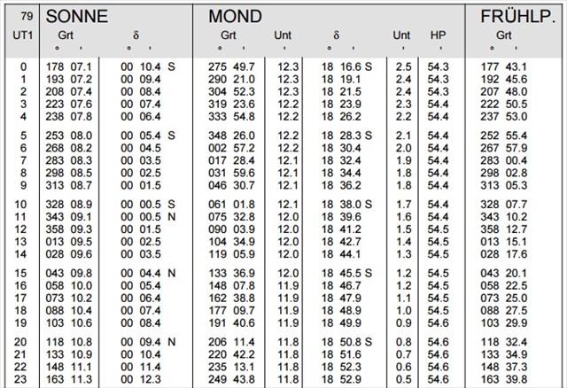
Mit einem Sextanten kann man normalerweise eine Position auf 5-10 km genau bestimmen. Die hier angebenen Messwerte haben 100fach höhere Genauigkeit. Mit den Werten aus den (ganz unten) abgebildeten Tabellen erhaltet Ihr brauchbare WGS-84 Cachekoordinaten. Eure Zielkoordinaten könnt Ihr im Checker prüfen. Wenn der ermittelte Bildpunkt der Sonne innerhalb einer 70m-Toleranz liegt, wird die Lösung akzeptiert und die genaue Koordinate des Cache angezeigt.
In 2 Metern Augenhöhe wurden zwei Messungen gemacht:
10:00 MEZ, 27° 39.622'
16:00 MEZ, 20° 21.263'
Hinweise:
Zur Vereinfachung rechnest Du mit UT1 = UTC. Aus den Tabellen sind die nächstliegend gefundenen Werte zu verwenden, keine Interpolation, keine Indexkorrektur.

[EN:]
A journey into the past .....
Imagine, we are in a time before May 1, 2000, before switching off the artificial deterioration of the GPS signal.
Or even earlier, before 17 July 1995, ie before the official start-up of the "Navigational Satellite Timing and Ranging - Global Positioning System".
Or even earlier, before 1964, before Transit, the GPS precursor, could at least be used militarily....
And imagine further, you should determine (thus before 1964) an exact position.
Without any of the technical aids that are so important for our modern GPS-Hunt.
Is that possible?
Yes, of course!
With a very accurate clock, a proper sextant, a lot of mathematical effort and the necessary knowledge about the secrets of astronavigation.....
And here begins your mission:
With a sextant you can normally determine a position to 5-10 km exactly. The measured values given here have a 100 times better accuracy. With the values from the tables shown below, you are able to get workable WGS-84 cachecoordinates. You can check your coordinates in the checker. If your coordinates are within a 70m tolerance, the solution will be accepted and the exact coordinates of the cache will be displayed.
Two measurements were taken at a eye level of two meters:
10:00 AM CET, 27° 39,622'
16:00 CET, 20° 21.263'
Note:
For simplification, you will calculate UT1 = UTC. You have to use the nearest found values from the tables, no interpolation, no index correction.
To avoid some translation problems: "Gesamtbeschickung in Winkelminuten für den Kimmabstand des Sonnenunterrandes" is the name of the table for the correction of the observed altitude - "Kimmabstand" means "apparent altitude", "Augeshöhe" means "eye level"
Notwendige Ausschnitte aus dem Nautischen Jahrbuch:
Necessary example from the nautic almanac:

Wer möchte und Spaß daran hat, kann sich nach dem Fund dieses Banner in sein Profil einbinden:
[EN:] If you like you may add this banner to your profile:

Dazu einfach folgenden HTML-Text in euer Profil einfügen:
[EN:] To do so just add the following HTML code to your profile
<a href="https://www.geocaching.com/bookmarks/view.aspx?guid=8f93395c-0be3-436f-bf79-0dfe860bbbc6">

<img src="https://s3.amazonaws.com/gs-geo-images/9c1405d3-cd4b-4c9c-bb58-69b4ee9084aa_l.jpg" width="275" border="1"

title="Das lächelnde Mega-Torhaus"></a> |