Powder Keg (Dunedin Hills Challenge) (Otago) Mystery Cache
Powder Keg (Dunedin Hills Challenge) (Otago)
-
Difficulty:
-

-
Terrain:
-
Size:  (large)
Please note Use of geocaching.com services is subject to the terms and conditions
in our disclaimer.
The Powder Keg is a 10 litre black bucket close to the Powder Hill trig. A map and route waypoints to get to Powder Hill are included below.
But, this is a Challenge cache. The first challenge is to read through the guidelines...
Dunedin is the second-largest city in New Zealand by land area. It stretches from the Pleasant River north of Waikouaiti to the Taieri River mouth, and from the summit of the Rock and Pillars to Taiaroa Head. Within that 3314 sq km we’re blessed with a range of enjoyable hill caches.
Your Challenge is to walk
to the highest caches
on ten different Dunedin hills,
before you blow up the Powder Keg.
These ten hill caches must be:
- Within Dunedin city boundaries (look at the WAMS map, Map Layers overlay, Administrative Boundaries)
- On hills 300 m or more high
- Require a walk (short or long) to reach them (so does not include roadside caches such as the one by the tarseal on top of Mt Cargill)
- Where there are several caches on a hill, you’re asked to find the highest one you can walk to (put the cache coordinates into Google Earth to find the altitude)
- Where there is doubt about whether a bump is a separate hill, check whether it has both a closed contour line around it AND an individual name on the WAMS map. (Therefore White Hill, Swampy Spur, Leith [Boulder View], Trig Q [Just Q] and the Knoll are not considered “separate hills”.)
Hills with caches fitting the criteria above include:
Harbour Cone
Mt Kettle
Signal Hill
Mt Holmes
Buttars Peak
Mt Cargill
Swampy Summit
Flagstaff
Silver Peak
Pulpit Rock
Green Hill
Maungatua
Rock & Pillars
Mt Cutten
There are also three hills with non-traditional caches high up on them – if you have found them, you’ll know which hills they are.
All the qualifying caches you’ve found since you started caching count towards this challenge. So you’re probably already well on the way towards completing it!
Email us with your list of ten qualifying caches and wait for acknowledgement before heading off to the final Powder Keg. Appropriate online logging of your qualifying finds is expected; a log doesn't have to be long, but just "TFTC" is not sufficient.
As other 300m+ hills in Dunedin have caches placed on or near the top, these will be added to the list.
If a new cache is placed higher on a particular hill, it will supersede the previous qualifying cache for those people still working on the challenge.
If a qualifying cache you have found is archived, it will still count towards completion of your challenge (unless it is also superseded by a higher cache placement).
If you would like a list of the qualifying traditional/earthcache/challenge hill caches, look at our bookmark list or email us (it can’t be included on the cache page).
Owners of a qualifying cache will have to log a maintenance visit to count as a “find” on their own cache- placing the cache doesn’t count towards this challenge. (Maintenance on an earthcache? Does that mean visiting and taking a photo to prove the earth's still there?)
This challenge and the Rambler's Reward Challenge are completely independent of each other. Except that people who enjoy rambling will also enjoy a bit of hill climbing! Where appropriate, you can use the same find to count towards both challenges.
If you have any questions about the guidelines or if there are other Dunedin hills with caches on them which should be included on the list, please email us.
Because you only have to go up ten out of the sixteen Dunedin 300m+ hills that currently have caches on them, this is a very achievable challenge. You are able to avoid the steeper and longer walks if you wish.
Extra-keen cachers who walk to the highest caches on all the Dunedin 300+ hills (including Powder Hill) will get their names listed on this cache page. Email to let us know! The first person to do all the hills will also be awarded a bottle of Emerson's (or non-alcoholic beverage of their choice).

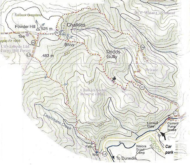
The Powder Keg
There are two routes to Powder Hill: Leishmans Ridge or the Chalkies track. Sadly, the old route up the north ridge of Dodds Gully is now closed, because it is private land between C2 and DN. Each route takes about an hour and a half to reach the top. The round trip can be done as a long morning. However, it's much more fun to sleep in and then have a leisurely lunch in the sun at the trig or the Chalkies. Enjoy the views! Or you might want to go up Powder Ridge and back down Long Ridge to Powder Hill... but that's a very long day, and I hear Long Ridge is now overgrown with gorse.
Leishmans Ridge: Go past Leishmans Falls up to Leishmans Falls Ridge. Continue up the track, through sub-alpine scrub and out to a forestry road at [LT]. Turn right and follow the road until it bends left. Pick up the Powder Hill track entry at [P1].
Chalkies: From the carpark, follow the track on the true left of the Silverstream until you are opposite the Chalkies road [C1]. There is a broken weir here which people use to get across the stream with dry feet. Go up the Chalkies road. At [C2] take the left fork and go up the steep bulldozed track to the ridge. The track stays on the ridge top, goes past the turnoff to Chalkies Reserve and up to the Powder Hill track junction [P4].
Additional Hints
(No hints available.)