KALVÁRIE (269m)
Vrch Kalvarie se nachazi na pravem brehu reky Labe u obce Velké Žernoseky. Rika se mu take Trikrizovy podle trech drevenych krizu umistených na ostrohu. Tyto krize jsou zminovany v historickych materialech jiz od r.1587 a vaze se k nim mnoho povesti, avsak nic podlozeneho.
Vrch je pro vyskyt stepni a lesostepni kveteny soucasti prirodni rezervace Kalvárie, vyhlasene v r.1993. Tu tvori skalnate svahy Kalvárie a Velké Venduly, jež jsou od sebe oddeleny Jelenim prikopem. Na nahorni plosine se nachazi zbytky valoveho opevneni z doby asi 1000 let pr.n.l. Rezervaci ozivuje na 80 druhu obratlovcu a pokud budete mit stesti, muzete potkat toho nejvetsiho z nich jesterku zelenou (lacerta viridis) dorustajici delky pres 30cm. Bohuzel i ona dnes patri mezi ohrozene druhy.
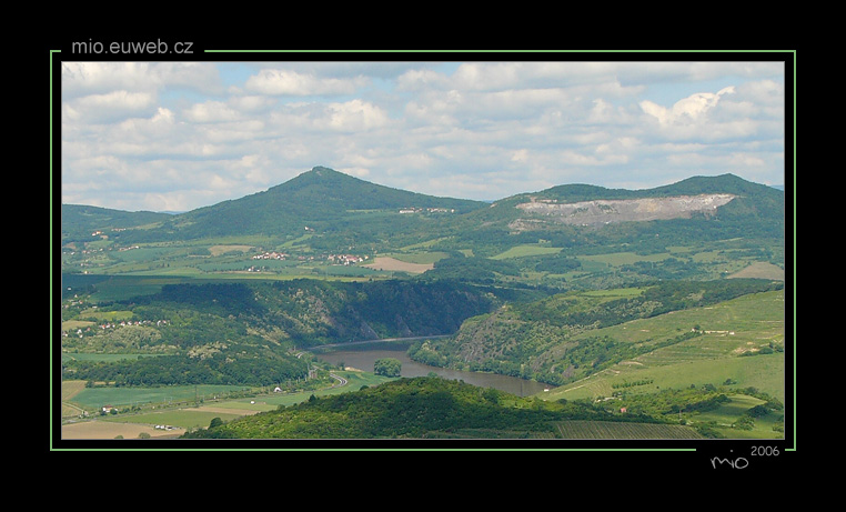
Z vyhlidky na Kalvárii je prekrasny pohled na Ceskou branu (Porta Bohemica). To je asi 3km usek mezi Velkymi Žernoseky a Libochovany, kde Labe proteka kanonem do oblasti Ceske stredohori. Kanon po obou stranach lemuji skalnate steny vysoke misty az 100 metru. Dale je videt mimo jine Radobýl, Lovoš, Kletecná, Milešovka, Hazmburk a nebo treba Ríp.
Vyrazit sem muzete po znacenych turistickych cestach z Velkých Žernosek (po zelené), Kamýku (po zelené) nebo z Libochovan (po žluté a pak pokracovat po zelené).
 KALVÁRIE (269m)
The top of Kalvarie is situated on the right bank of river Labe near the village Velké Žernoseky. It also called "three crosses" according to three wooden crosses located on the bill. These crosses have been mentioned in historical materials since 1587 and they are connected to many legends but there are no proofs.
The top is a part of the National Rezervation Kalvárie because of occurrence of steppe and hoodsteppe flora, proclaimed in 1993. It is formed by rock slopes of Kalvárie and Velká Vendula which are separated from each other by Jelení Príkop. On the tableland there are remainders of the mound fortification from the age about 1000 years B.C. The rezervation is revived by 80 species of vertebrates and if you are lucky, you can meet the biggest of them lizard the green (lacerta viridis) growing up to the lenght of 30 cm. Unfortunatelly it adherends to an endagered species these days.
From the viewpoint on Kalvárie is a beautiful outlook at "Czech Gate" (Porta Bohemica) which is about 3km long stage between the villages Velké Žernoseky and Libochovany where the river Labe flows through he canion to the area of Ceské Stredohorí. The canion is from the both sides flanked by rock walls hight up to 100m. You can also see Radobýl, Lovoš, Kletecná, Milešovka, Hazmburk or Ríp.
You can set out here along the pathways with tourist marks from the village Velké Žernoseky (signed by green mark), from the village Kamýk (signed by green marks) or from the village Libochovany (signed by yelow marks and continue with green).