22 A Walk in the Garden-The Brokaghs Multi-cache
22 A Walk in the Garden-The Brokaghs
-
Difficulty:
-

-
Terrain:
-

Size:  (regular)
Please note Use of geocaching.com services is subject to the terms and conditions
in our disclaimer.

Visit The Geocaching Ireland discussion
forum HERE
By death the moon was gathered in Long ago, ah long
ago;
Yet still the silver corpse must spin
And with another's light must glow.
Her frozen mountains must forget
Their primal hot volcanic breath,
Doomed to revolve for ages yet,
Void amphitheatres of death.
And all about the cosmic sky,
The black that lies beyond our blue,
Dead stars innumerable lie,
And stars of red and angry hue
Not dead but doomed to die.
— Sir Julian Huxley
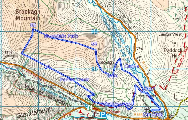
An easy and very beautiful hike of about two and a half hours, 9K
and a total ascent of approx 550m. Of the Garden series of cache
hikes, this would probably be the most accessible to the widest
range of walking levels. There are many ways to approach the three
stages and the cache but I used the one described in the map above
walking in a clockwise direction. The car parking is at N53 00.637
W006 18.178 very close to the Kevin and the Blackbird cache. You
may approach the stages any way you wish of course, including
walking directly to the coordinates above, but I recommend using
the forest track with the barrier that is obvious from the car
park. The difference is very slight and you will avoid any local
disputes over rights of way that apparently exist on the driveable
routes.
If you prefer to stick to forest tracks and mountain paths then
almost the entire hike can be done in this way.
After leaving the car park and arriving at the start of the trek,
the route then follows the Wicklow Way (black posts with yellow
arrows) winding from the car park as far as the turn off at N53
00.805 W006 19.465. (PLEASE NOTE THAT VIRTUALLY NOTHING OF THE WIDE
FOREST TRACKS FROM HERE ONWORD APPEAR ON THE OSI MAP SO IT IS BEST
TO BE GUIDED BY MY ILLUSTRATION ABOVE OR PERHAPS USING GOOGLE
EARTH!). Here we continue on straight and soon after turn sharply
right at N53 00.881 W006 19.671, and then sharp left at N53 00.856
W006 19.515 and then on straight for some time to Stage 1.
Stage 1. At N53 01.342 W006 20.584 you will find two numbers. Call
these AB as you see them.
For the present and until such time as I can visit to check
these two numbers are the same as Jesus Christ's age when he
died!
PLEASE CONCEAL THE ITEM COMPLETELY AFTER YOU GET THE NUMBERS!
Continue along the forest track till you come to the end of the
forest at N53 01.494 W006 20.931. Here you need to turn right and
head for the summit of Brokagh Mountain where you will find stage
2.
Stage 2. At N53 01.853 W006 20.905 you will find another two
numbers. Call these CD as you see them. PLEASE MAKE SURE TO HIDE IT
COMPLETELY UNDER THE BOULDER AND HEATHER AS OCCASIONAL SUMMER
VISITORS MAY WISH TO LOOK FOR ITEMS FOR FIREWOOD!!!
There is a mountain path which will take you directly from here to
the smaller Brokagh top and stage 3.
Stage 3. At N53 01.534 W006 19.435 you will find two more numbers.
Call these EF. PLEASE BE CAREFUL, AS BEFORE, TO COMPLETELY HIDE
IT!
The final cache can be found at N53 01.ABC W006 18.DEF.
To get from stage three to the cache the most direct way there is a
gate back to the nearest forest track at N53 01.214 W006 19.042 and
you need to come down to it in order to take in the final cache on
your way back to the car park.
As you exit the gate there is a right turn and two to the left.
Ignore the right turn and take the lower of the other two that is
heading DOWNWARD as your GPS should be indicating for the cache.
Shortly after you should pass another right turn continuing shortly
again to another junction at which point you should keep RIGHT and
follow this forest track down to a sharp right turn which will take
you to the cache and on to the car park.
From Mountain Views:
Brockagh Mountain Mountain Wicklow County
Brocach A name in Irish (Ir. Brocach + Eng. mountain [PNCW], 'place
frequented by badgers'
Height: 557 metres OS 1/50k Mapsheet: 56 for top
Grid Ref: T10858 99057 Latitude: 53.031011 Longitude: -6.348360
ITM: 710782 699090
Brockagh is a townland in the parish of Derrylossary.
Brockagh Mountain is the 347th highest summit in Ireland.
Do not start the trek without
all the proper mountain rain gear, waterproof boots and the
guidance material, compass, map, GPSr with mapping etc.
Deer hunting takes place in forests close to this trekking area so
please take note of any signs to that effect and avoid these areas
and times (1st Sept to March).
Please note that all parts of this cache are hiked at your own
risk. The cache owner takes no responsibility of any sort for any
reason including accidents or
mishaps.
Please be aware that cars parked
in areas close to walking trails are vulnerable and they can be
vandalised or stolen. Unfortunately this is an ongoing problem
which is extremely difficult to solve. so there is a risk involved.
I have heard recently that many hiker groups are parking at the
nearest population centres and getting taxis to and from the start
points at very little expense.
Please observe the country code to the best of your ability. Local
landowners often generously allow access to upland areas across or
through parts of their private property. Please, please be
conscious of this and return the courtesy by keeping all gates
closed, immediately and not on your way back!. Please use the gates
where appropriate but if you have to climb over them then use the
hinged side ONLY.
Please do not cause any damage of any sort to fences or barriers
along the way.
Additional Hints
(Decrypt)
F1. Orfvqr ynetr obhyqre yrsg bs genpx.
F2. Haqre obhyqre naq urngure.
F3. Haqre urngure ng yrsg fvqr bs ebpx sbezngvba.
Pnpur: genpxfvqr ebpxf.