
LOOKING GLASS
FALLS

Looking Glass Falls is one of the most scenic and best known falls in the Eastern United States; and one of the most popular falls in Western North Carolina. The name "Looking Glass" comes from the immense dome of nearby Looking Glass Rock, where water freezes on its sides in the winter and then glistens in the sunlight like a mirror or looking glass. This picturesque unbroken rush of water is 30 feet wide and over 60 feet high, visible from U.S. 276 just a few miles past the entrance to Pisgah National Forest. The fall is right beside the road for roadside viewing, photo opportunities and is very assessable even to the handicapped. There also is a very easy walk down concrete steps that lead to the base of the falls. Looking Glass Falls is considered a"10" on the beauty scale.
A waterfall is usually a geological formation resulting from water, often in the form of a stream, flowing over an erosion-resistant rock formation that forms a nickpoint, or sudden break in elevation. Some waterfalls form in mountain environments in which the erosive water force is high and stream courses may be subject to sudden and catastrophic change. In such cases, the waterfall may not be the end product of many years of water action over a region, but rather the result of relatively sudden geological processes such as landslides, faults or volcanic action.
The story of Looking Glass Falls began about a billion years ago with the collision of ancient continents to form the super continent of Rodinia. This collision crumpled and thickened the crust burying the rock that would become Looking Glass Falls some 5 miles under high mountains. Rocks that are buried this deep are exposed to temperatures over 1000° F and pressures over 150,000 pounds per square inch. These temperatures and pressures cause minerals to crystallize into layers and also to become folded or wrinkled. These metamorphic rocks can be seen at Looking Glass Falls in the different colored and folded layers of rock.
About 750 million years ago the super continent of Rodinia began to break apart. The two main continents were formed from the breakup, Laurentia which would later become North America and Gondwana which would later become South America and Africa. At this time Looking Glass Falls was near the southern coast of Laurentia, if you had your GPS then you would have been at about 25° south longitude.
About 330 million years ago Gondwana collided with Laurentia , this collision pushed up the deep buried metamorphic rock to form the Appalachian Mountains. Geologists have estimated the height of the Appalachians at this time to be an average of 26,000 feet. The collision of Gondwana and Laurentia formed the next super continent known as Pangea.
During the Triassic period about 220 million years ago the super continent of Pangea began to break apart. As what happened before with Rodinia the crust cracked and sank as it stretched apart. A great rift basin formed north to south along what are now the east coast of North America and the west coast of Africa. This basin has grown 4000 miles to what is now the Atlantic Ocean.
The past 200 million years weather has eroded the Appalachian Mountains to there present height and rounded form. Streams such as the Davidson come from springs in the higher mountains that flow into rivers, lakes and eventually the Atlantic Ocean or the Gulf of Mexico. As these streams flow down the mountain they encounter drop off in the rock that create waterfalls such as Looking Glass Falls. So as you look at the beauty of Looking Glass Falls think about the amazing journey these rocks have taken from being buried 5 miles deep below the earth to rise over 20,000 feet above just to be worn down by weather and time.
There are several types of waterfalls:
BLOCK: the water descends from a relatively wide stream or river.
CASCADE: the water descends a series of rock steps.
CATARACT: A large waterfall.
FAN: water spreads horizontally as it descends while remaining in contact with bedrock.
HORSETAIL: The descending water maintains some contact with bedrock.
PLUNGE: the water descends vertically, losing contact with the bedrock surface.
PUNCHBOWL: water descends in a constricted form, and then spreads out in a wider pool.
SEGMENTED: separate (distinctly) flows of water form as it descends.
TIERED: the water drops in a series of distinct steps or falls.
MULTI-STEP: a series of waterfalls one after another of roughly the same size with each its own sunken plunge pool.
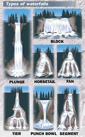
Some Of The Types of Waterfalls
This magnificent waterfall and pool took millions of years to form so enjoy it and take care of it.
In order to receive credit for the Earthcache you must do the following:
Email me with the answers to the following questions:
Each cacher is required to send the required information and not rely on another cacher to provide it. Failure to follow this procedure will result in a deleted log. It is not my job to keep track of your group.
1. Using the above classification, what type of waterfall is this?
2. What is the name on the bench at the above coords at the bottom of the steps?
3. How many steps from the top to the bottom?
4. What is the elevation at the above coords?
5. While you are at GZ look closely at the rock that has been worn away over the many years, what type of rock is this?
EXTRA CREDIT 6. What is the name of the river that flows over these falls?
Photos are fun and additional proof that you were actually there. If you desire, upload a photo of you and/or your group OR a photo with just your GPSr visible at the above listed coordinates with the falls in the background.
XXXXXXXXXXXXXXXXXXXXXXXXXXXXXXXXXXXXXXXXXXXXXXXXXXXXXXXXXXXXXXXXXXXXXXXXXXXXXXXX
We became Platinum Earthcache Masters on September 17, 2007.
We were the first to request and receive on July 2, 2011 the Emerald Discovery Award for finding 500 or more Earthcaches.
We received the Diamond Discovery Award on June 17, 2012 for finding 1,000 or more Earthcaches.


XXXXXXXXXXXXXXXXXXXXXXXXXXXXXXXXXXXXXXXXXXXXXXXXXXXXXXXXXXXXXXXXXXXXXXXXXXXXXXX
