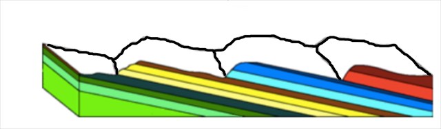
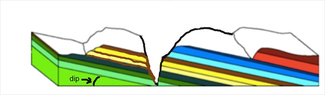
Looking out at the cliffs you can see the folded sandstone layers deposited over the millennia when this was a marine basin hundreds of millions of years ago.
Later, starting about 20 million years ago, volcanic activity resulted in massive lava flows over the land, filling the existing river valleys and displacing the old river courses, forcing the water runoff to find new channels. The volcanic activity uplifted the sandstone layers.
Over time, these new rivers eventually eroded deep paths through the land. With ice ages ebbing and flowing, the rivers were sometimes much wilder than they are today - imagine the huge cascade that would once have poured over the broken rock of these cliffs.It has taken around 20 million years for the canyon to erode. That’s about 10 metres per million years.
In more recent times, geologically speaking, Aboriginal people have occupied this land through the most recent ice ages. They would have seen icecaps forming on the tiers, and forests gradually giving way to grasslands at the height of the cold periods.
Alum Cliffs was a place of particular social and spiritual significance to Aborigines because of the ochre to be found in that area of the Gog Range. Many tribes travelled to the cliffs they named Tulampanga, which translated means ‘red ochre hill’, to obtain this highly prized material and for them this was a sacred celebration place.
The connection of Aboriginal people with the Mole Creek area is thought to date back more than 10,000 years, and the Pallittorre band of the North tribe was based around Mole Creek/Meander. To these early inhabitants, the Great Western Tiers were known as Kooparoona Niara, or Mountains of the Spirits, culturally significant as the meeting place of three Aboriginal nations.
It is believed the ochre deposits were produced by oxidation of carbonate in the sandstone and iron ore suspended in the water as it made its way downslope.
Ochre is a family of earth pigments, which includes yellow ochre, red ochre, purple ochre, sienna, and umber. Ochres are non-toxic, and can be used to make an oil paint that dries quickly and covers surfaces thoroughly. The major ingredient of all the ochres is iron oxide, which is one of the most common minerals found on earth.
There is no physical cache container. Instead to claim a find please e-mail answers to the following questions to the cache owner. Do not include the answers in your log.
1. Estimate how high above the river the viewing platform is? Does this agree to the erosion rate stated in the description above?
2. Describe the colour and texture of the ochre and that of the sandstone.