Anglais:
First visit the Visitor Center of the National Park (maps, permanent exhibitions).
At the exit of the Visitor Center, take the wide path that leads to the Diamond Hill, which is easily spotted. The latter is well marked, from blue first to Lower Diamond Hill. On many occasions, thick beams support the trail. To leave it is to run the risk of ending up to the ankles in the greasy and spongy peat which constitutes most of the vegetation.
An intersection allows you to take the direction "Upper Diamond Hill". Peat leaves little by little the place to the rock for this ascent of about 2km which takes you to the summit. Although easy, this climb requires special attention if the weather is wet, as rocks can be slippery.
From the summit, continue on the short ridge and start the descent (steps, easy path) which allows to reach the intersection quoted above. From there, follow the signposted Blue Trail, which leads to the Earthcache and the Visitor Center via the Bog Road, which crosses the bog.
Français:
Visiter tout d’abord le Visitor Centre du parc national (cartes, expositions permanentes).
A la sortie du Visitor Centre, prendre le large sentier qui se dirige vers la Diamond Hill, que l’on repère aisément à vue. Ce dernier est fort bien balisé, de bleu tout d’abord jusqu’au "Lower Diamond Hill". A de nombreuses reprises, des poutres épaisses viennent soutenir le sentier. Le quitter, c’est risquer de se retrouver jusqu’aux chevilles dans la tourbe grasse et spongieuse qui constitue l’essentiel de la végétation.
Une intersection vous permet de prendre la direction "Upper Diamond Hill" (balisage rouge). La tourbe laisse peu à peu la place au rocher pour cette montée d’environ 2km qui vous emmène jusqu’au sommet. Bien que facile, cette ascension nécessite une attention particulière si le temps est humide, les rochers pouvant s’avérer glissants.
Du sommet, poursuivre sur la courte arête et amorcer la descente (marches taillées, sentier aisé) qui permet de rejoindre l’intersection citée plus haut. De là, suivre le sentier balisé de bleu, qui permet de rejoindre le site de la Earthcache et le Visitor Centre via la "Bog Road", qui traverse la tourbière.
Allemand:
Besuchen zunächst das Besucherzentrum Nationalpark (Karten, Dauerausstellungen).
Auf das Besucherzentrum verlassen, nehmen Sie den breiten Weg, der zu dem Diamond Hill, die leicht Wahrzeichen Anblick geht. Letzteres ist gut markiert, zunächst blau auf „Lower Diamond Hill“. Bei vielen Gelegenheiten, dicke Balken unterstützen die Spur. Der Urlaub ist zu riskieren knöcheltief im Fett und schwammig Torf enden macht den größten Teil der Vegetation auf.
Ein Schnittpunkt ermöglicht es Ihnen, in Richtung „Obere Diamond Hill“ (rote Markierung) zu nehmen. Torf weicht allmählich für diesen Anstieg von ca. 2 km, die nach oben führt zu rocken. Obwohl leicht, dieser Aufstieg besondere Aufmerksamkeit erfordert, wenn das Wetter nass ist, können die Felsen rutschig sein.
Vom Gipfel, weiter auf der kurzen Seite und beginnt den Abstieg (gehauene Stufen, einfacher Weg), die Gäste in der Kreuzung oben erwähnt nimmt. Von dort folgen Sie dem markierten Weg von Blau, Earthcache und die das Besucherzentrum über die „Bog Straße“ erreichen kann, die durch das Moor führt.

Hello I'm french
During a nice trip in April 2017 in this beautiful country of Ireland, I thought that this beautiful park deserved an EarthCache. After the beautiful hike to the top (accessible to everyone, it's not too difficult) I discovered this great site to place my cache. Thanks for coming. Geofrendly MarMax57
Geology of Connemara:
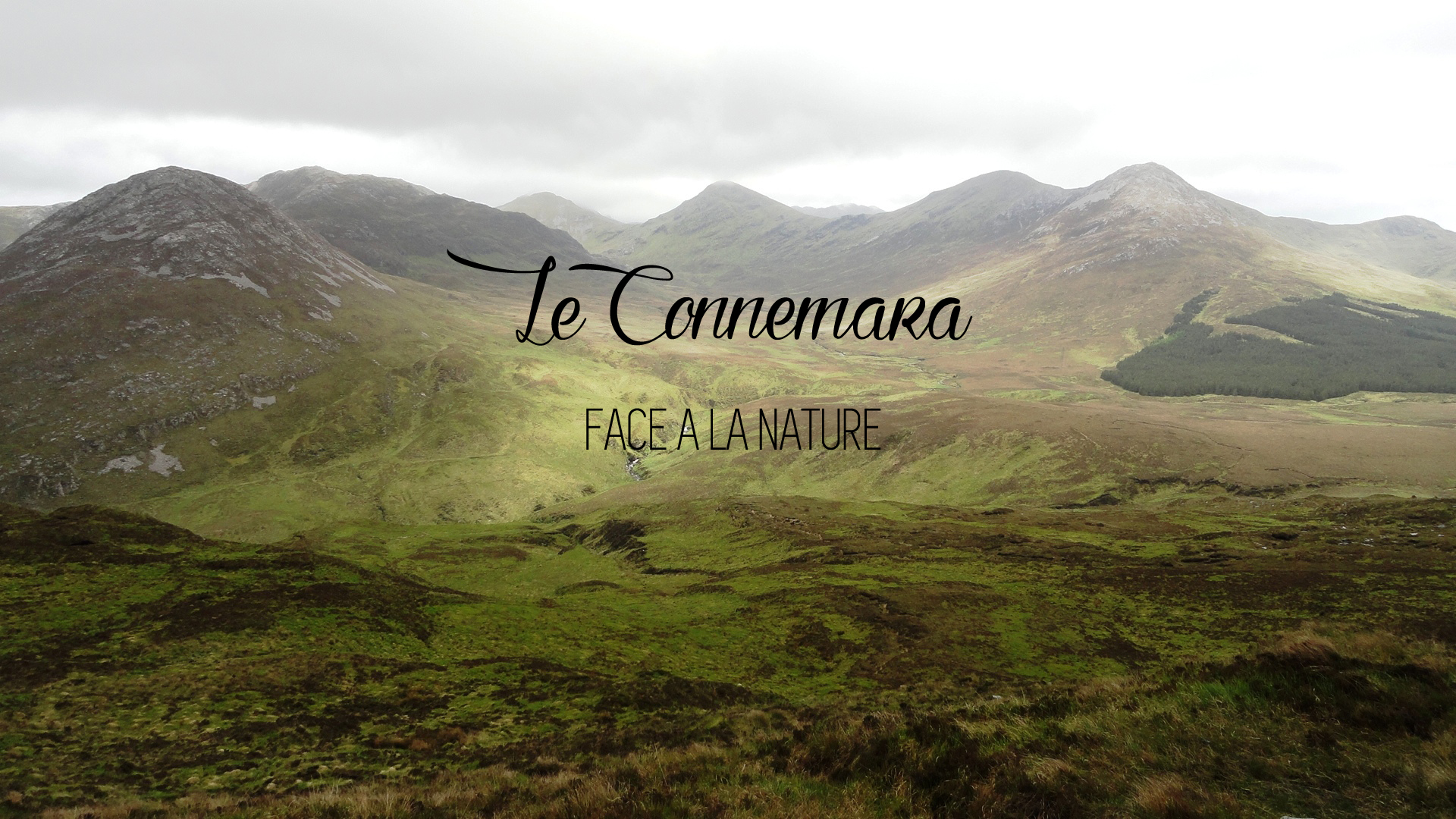
This wonderful park is one of Ireland's 5 national parks. It covers 2,000 acres of countryside and mountains of Connemara. Although it is sparsely populated, Connemara alone is a region in its own right. Part of the county of Galway, it is one of the most beautiful country in Europe. Remaining very agricultural, it is characterized by a certain abundance of beast, so much so that it is not uncommon to see sheep, cows or goats erroneous by the roadside. Note the importance of the cultivation of peat, used as traditional heating. But what marks the visitor above all is the beauty of the landscapes and the contrasts of lights. Time has not taken hold on this country and the impression of seeing itself 50 years back is not usurped. Starting from Galway, and heading westwards, you are suddenly taken by these landscapes of small arid mountains which can very well recall the south of Europe, these fields of peat and barley, these lakes of a Bright blue, this breathtaking light, these castles or residences abandoned by any nobles and taken over by wealthy Americans of Irish origin, and those little houses with thatched roof still inhabited, and finally, once arrived at destination Encounter between the shores of Connemara and the Atlantic Ocean, the path to the New World. Part of the County the Aran Islands can be considered as a world apart, because of its geology and the Gaelic language which like all the West of Ireland has been able to stand up to time and invasions.
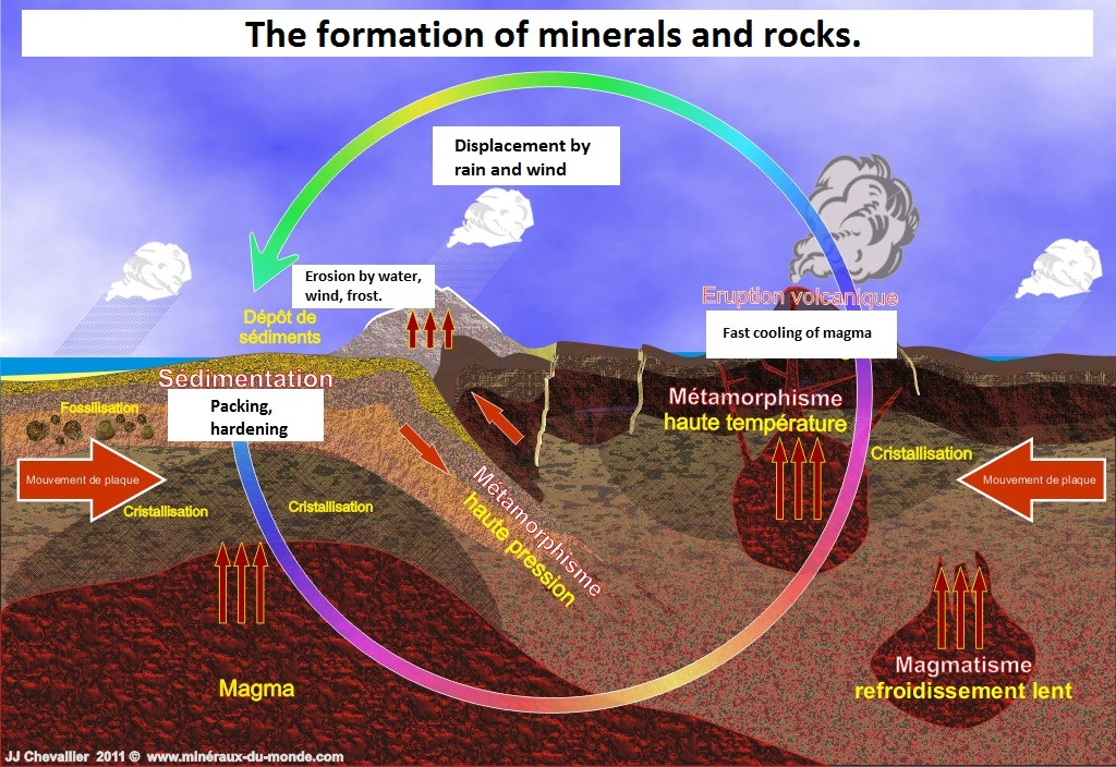
Underlying rocks of Connemara are metamorphic rocks, resulting from the transformation of sediments deposited in a warm sea that stretched over the region between 700 and 550 million years. These sediments have been transformed by geological activity into crystalline schists which have ascended to the surface. The summits of the mountains of the park are mostly composed of quartzite, more resistant than the shales and the gray marbles composing the flanks.
The current landscape was set by the last glacial era, which ended 10 000 years ago, which left sand and gravel deposits, clay in blocks and erratic rocks, which play a decisive role In the composition of the flora of the park.
To validate this Earthcache send me the answers to the following questions:
1 / At the coordinates you can see around you 7 different rock types like a panel with their names, tell me the name and rock type of number 7.

2 / You can read there a geological thermme coming from an ancient Celtic tribe, what is this therme?
3 / If you wish add a photo of you in the park of Connemara to your log.

Bonjour je suis francais
Lors d'un beau voyage en avril 2017 dans ce magnifique pays d'Irlande, j'ai pensé que ce parc méritait un EarthCache. Après la belle randonnée jusqu'au sommet (accessible à tout le monde, ce n'est pas trop difficile), j'ai découvert ce site génial pour placer ma cache. Merci d'être venu. Géoamicalement MarMax57.
Géologie du Connemara:
Ce merveilleux parc est l'un des 5 parcs nationaux d'Irlande. Il couvre 2.000 hectares de campagne et de montagnes du Connemara. Bien que très peu peuplé, le Connemara est à lui seul une région à part entière. Faisant partie du comté de Galway, c'est une des plus belle contrée d'Europe. Restée très agricole, elle se caractérise par une certaine abondance de bétail, à tel point qu'il n'est pas rare de voir des moutons, vaches ou chèvres errés au bord de la route. A noter l'importance de la culture de la tourbe, utilisée comme chauffage traditionnel. Mais ce qui marque le visiteur avant tout c'est la beauté des paysages et les contrastes de lumières. Le temps n'a pas eu de prise sur ce pays et l'impression de se revoir 50 ans en arrière n'est pas usurpé. A partir de Galway, et en partant vers l'Ouest, on est pris soudain par ces paysages de petites montagnes arides qui peuvent très bien rappeler le sud de l'Europe, ces champs de tourbes et d'orge, ces lacs d'un bleu vif, cette lumière intense à couper le souffle, ces châteaux ou demeures abandonnés par quelconques nobles et repris par des richissimes américains d'origine irlandaise, et ces petites maisons au toit de chaume encore habitées, et enfin, une fois arrivé à destination cette rencontre entre les rivages du Connemara et l'Océan Atlantique, chemin obligé vers le Nouveau Monde. Faisant partie du Comté les îles Aran peuvent être considérées comme un monde à part, en raison de leur géologie et de la langue gaélique qui comme tout l'ouest de l'Irlande a su tenir tête au temps et aux invasions.
Les roches sous-jacentes du Connemara sont des roches métamorphiques, issues de la transformation de sédiments déposés dans une mer chaude qui s'étendait sur la région il y a 700 à 550 millions d'années. Ces sédiments ont été transformés par l'activité géologique en schistes cristallins qui ont remonté jusqu'à la surface. Les sommets des montagnes du parc sont majoritairement composés de quartzite, plus résistant que les schistes et les marbres griscomposant les flancs.
Le paysage actuel a été fixé par la dernière ère glacière, qui a pris fin il y a 10 000 ans et qui a laissé des dépôts de sable et de gravier, de l'argile en blocs et des rochers erratiques, qui jouent un rôle déterminant dans la composition de la flore du parc.

Pour valider cette Earthcache envoyez moi les réponses aux question suivantes:
1/ Aux coordonnées vous pouvez voir autour de vous 7 types de roches différentes ainsi qu'un panneau avec leurs noms, dites-moi le nom et le type de roche de la numéro 7.
2/ Vous pouvez y lire un terme géologique venant d'une ancienne tribu Celtique, quel est ce terme ?
3/ Si vous le souhaitez ajoutez à votre log une photo de vous dans le parc du Connemara.

Hallo ich bin französisch
Während einer wunderschönen Reise im April 2017 in dieses wunderschöne Land Irlands dachte ich, dieser Park hätte einen EarthCache verdient. Nach der wunderschönen Wanderung nach oben (für jedermann zugänglich, es ist nicht allzu schwierig), entdeckte ich diese großartige Seite, um meinen Cache zu platzieren. Danke, dass Sie gekommen sind. Geomagnetisch MarMax57.
Connemara Geologie:
Dieser schöne Park ist einer der fünf Nationalparks in Irland. Es umfasst 2.000 Hektar Land und die Berge von Connemara. Obwohl dünn besiedelt, ist Connemara an sich schon eine eigene Region. Im Rahmen des County Galway ist einer von Europas schönsten Landschaften. Blieb sehr landwirtschaftlich, wird es durch eine gewisse Fülle von béail bis zu dem Punkt gekennzeichnet, dass es nicht ungewöhnlich ist, um zu sehen, Schafe, Kühe oder Ziegen am Straßenrand streifte. Beachten Sie die Bedeutung der Kultur von Torf, als herkömmliche Heizung verwendet. Doch was kennzeichnet die Besucher am meisten ist die schöne Landschaft und die Lichter der Kontraste. Die Zeit ist in diesem Land nicht getroffen und fühlt sich wieder vor 50 Jahren gerecht zu werden ist nicht usurpiert. Von Galway, und nach Westen ausgehend, wird es durch die Landschaft von kleinen kahlen Bergen plötzlich genommen, die sehr gut den Süden Europas erinnern kann, diese Felder aus Torf und Gerste, diese Seen ein hellblau, der intensive Licht Atem, diese Schlösser oder von einem edlen verlassenen Villen und von reichen Amerikanern irischer Abstammung übernommen, und diese kleinen Häuser noch Reetdach bewohnt, und schließlich kamen einmal dazu treffen zwischen den Ufern von Connemara und dem Atlantischen Ozean Weg in der neuen Welt verpflichtet. Ein Teil der Aran Islands County eine Welt für sich betrachtet werden, wegen seiner Geologie und der gälischen Sprache als ganze Westen Irlands ist es gelungen, Zeit und Invasionen zu stehen.
Die zugrunde liegenden Felsen sind metamorphen Gesteine, aus der Umwandlung von Sedimenten in einem warmen Meer abgelagert, die zwischen 700 und 550 Millionen Jahre über den Bereich gespannt. Diese Sedimente wurden durch geologische Aktivität in kristallinen Schiefern umgewandelt, die die surface setzen haben. Die Berggipfel des Parks sind hauptsächlich aus Quarzit bestehen, stärker als Schiefern und grauen Marmor flancs die Komponente.
Die aktuelle Landschaft wurde durch die letzte Eiszeit gesetzt, die dort gelandet sind 10 000 Jahre, die Ablagerungen von Sand und Kies, Ton Blöcken und Findlingen links, die eine Schlüsselrolle spielen in der Zusammensetzung der Flora von parc.
Zur Validierung dieser Earthcache senden Sie mir die folgenden Fragen beantwortet:
1 / Einzelheiten können Sie rund um Sie 7 verschiedene Gesteinsarten als Zeichen mit ihren Namen sehen, sagen Sie mir den Namen und die Nummer 7 der Gesteinsart.
2 / Sie können eine geologische therm aus einem alten keltischen Stamm lesen, was ist das therm?
3 / Wenn Sie Ihre Log ein Foto von Ihnen in der Connemara Park hinzuzufügen