BE SMART - BEFORE YOU GO: Geocaching, as with other outdoor activities, involves risk; always exercise common sense and caution. I never intend for anyone to cross onto private or posted property, nor damage the environment during a search. Pre-planning and continued awareness to changing variables such as, but not limited to recreational and commercial (e.g. logging)) use of the area, terrain, vegetation, wildlife, weather and personal fitness and outdoor experience are always musts. As a minimum, cachers should have some set of the 10 Essentials tailored to the nature of the hike. DON'T RELY SOLEY on a cellphone, GPS device or other electronic device. Let someone know where you're going; know your limitations and stick to your “turn around” criteria. .
THE CHALLENGE: Based on the mean sea-level elevation of caches found, the challenge is to acquire a cumulated elevation equivalent to 500 statute miles. Acquiring the elevation could be as simple as walking a few flights of stairs from the parking lot, as I did for the Pu'u'ula'ula (Red Hill) Haleakala Volcano Summit Earthcache (GC18Z99), my highest cache, or lining up to navigate the Hillary Step (or where it used to be) for success with the “Earth's Roof - Mount Everest Peak” Earthcache (GC2BX63).
 Climbers Wait In Line To Reach The Summit of Everest (Nirmal Purja/Nepal)
CACHE BACKGROUND: The most rewarding challenge I’ve completed to date is Shaddow’s now archived “50,000 Feet Elevation Challenge” (GC24K9Z), a physical, endurance and educational challenge that emphasized pre-planning, map reading, attention to detail and post-hike analysis. I strongly recommend taking time to review the cache page. The effort of Shaddow to manage the challenge had to have been extreme. Ironically, Shaddow initially tossed out the idea of a 100,000 Feet Elevation Challenge, but, after receiving considerable feedback from the community, settled on 50% of the intended goal.
CACHE LOCATION: On a trek to the summit of Blowdown Mountain earlier in the year, I stumbled (almost literally), upon the original 50,000 Feet Elevation Challenge container. I quickly reached out to Shaddow for permission to re-purpose the container for a new challenge I had in mind. Knowing I’d not lug the 50 caliber ammo can and contents off the mountain, Shaddow gave me the go-ahead.
The repurposed container, a M2A1 Ammunition Can, remains atop Blowdown Mountain, which lies within the boundaries of the Mount Si Natural Resources Conservation Area. Blowdown Mountain, with an elevation of 4560 ft., is almost 400 feet higher than Mount SI (4,180 ft.) and just 228 feet lower than Mount Teneriffe (4,788 ft.) but, as noted on Peakbagger.com, and probably why it’s not a crowd gatherer, “There are no views …just trees."
Cachers can reach the summit via a number of trailheads off Southeast Mount Si Road (see table, below). Depending on the route taken, plan on an elevation gain of 3,700 – 4,000 feet to the summit and a round trip distance of roughly 11 miles. The trail off the Si-Teneriffe Connector Trail to GZ is more or less a sporadically marked, rugged boot path.

RATING:
- Difficulty ("D"): A “D” rating of 3.0 seemed in line with other elevation challenges created to the 2016 revision of challenge cache rules. For sure, the geographical area where a geocacher caches will influence the difficulty. For illustration purpose only, using a state’s mean elevation as the average cache elevation, here are a few examples of the effort to acquire 500 miles of elevation.
- Delaware: With a mean elevation of 60 feet, a geocacher would have to have found 44,000 caches to qualify. Yet, as of the writing of this description, there were just 2,894 caches in Delaware. No doubt a road trip or two would be warranted.
- Colorado: In the state with the highest mean elevation - 6,800 feet, it would take just 390 finds to qualify.
- Alaska: The state with the highest elevation - Denali at 20,320 feet - has an average elevation of 1,900 feet. If solely caching within the boundaries of "The Last Frontier" state, a cacher would need to have found 1,390 caches.
- Washington: For cachers active in Washington, listed as 18th in mean elevation (1,700 ft), roughly 1,560 caches would be necessary.
- For interstate cachers, the mean elevation of the 50 United States and territories is 2,500 feet or approximately 1,100 caches of average mean elevation.
THE RULES:
- You must have found any number of geocaches that, based on mean sea level elevation, yield a cumulative elevation that surpasses an equivalent of 500 statute miles (2,640,000 feet).
- All caches types qualify, no matter the state, country or planet. Sorry, NASA's Mars Perseverance Rover won’t help.
- You can sign the physical log at any time.
- To log this as found online, you must demonstrate you meet the “challenge” by using the Challenge Checker below.
- PLEASE, to facilitate populating the "CHALLENGE RANKINGS" table below, copy/and paste the text from the “Example Log” section of the Challenge Checker results in your "Found It" log posted to Geocaching.com.
E.g.: “X-Huey-Drv](https://www.geocaching.com/profile/?u=X-Huey-Drv) has used [Project-GC](https://project-gc.com/Challenges/GC8WT2G/53002 "Project-GC Challenge Checker") to see if they qualified for this challenge and they did.
Your total elevation must surpass 2,640,000 feet. Qualifying 4280113 / 2640000, PASSED”
CHALLENGE CHECKER:

** Congratulations rakis2 and geohound Rambo for FTF.**
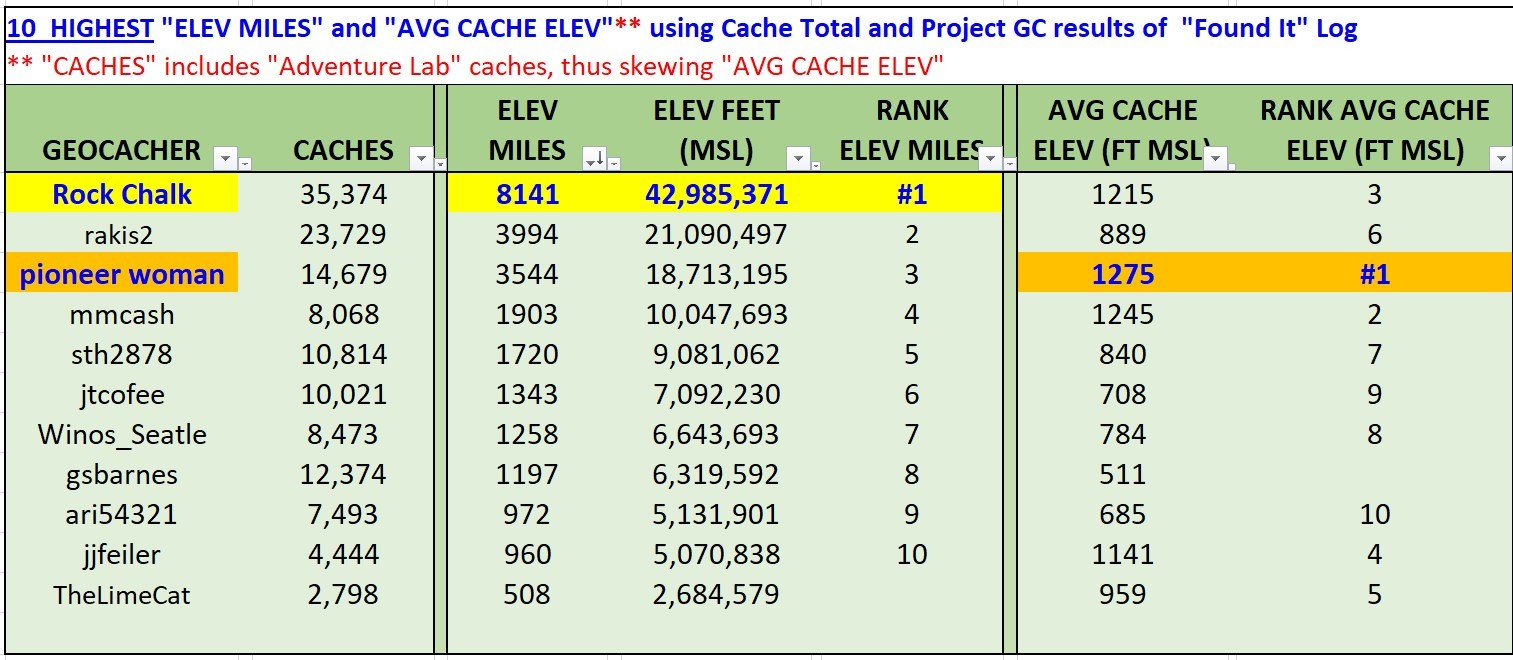
500 MILE ELEVATION CHALLENGE RANKINGS