Jeju's Hallasan EarthCache
-
Difficulty:
-

-
Terrain:
-
Size:  (other)
Please note Use of geocaching.com services is subject to the terms and conditions
in our disclaimer.
Jeju's Hallasan
|
Hallasan is a massive shield volcano which forms the bulk of Jeju Island and is often taken as representing the island itself. There is a local saying stating that "Jeju Island is Hallasan; and Hallasan is Jeju."
Hallasan was created by eruptions millions of years ago during the Pliocene epoch of the Cenozoic era by a volcano that is now dormant. The island was constructed atop the continental shelf, which is presently about 100 m (300 ft) below sea level in that area. Eruptions of lava built the island above sea level, and it now reaches a height of 1,950 m (6,398 ft). A large volcanic crater tops the volcano. About 360 parasitic cones are found on the volcano's flanks, mostly cinder cones and scoria cones but also including some lava domes and about 20 tuff rings near the coast and offshore, which were formed by underwater phreatic eruptions. Credit for the above photo goes to Jejusamda Museum. Be sure to visit their website for the Formation of Jeju Island.
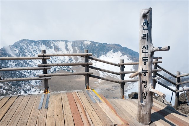
Hallasan's crater lake has been named Baengnokdam, literally 'white deer lake', in accordance with a legend that benevolent wizards used to descend from heaven to ride on white deer along the shores of the lake. The size of the lake varies with the rainfall and the season, and at its largest is about is up to two kilometres in circumference with a depth up to about 100 meters. |
Note: Please follow the below Photo & Email requirements. Edited/photo-shopped photos are not allowed.
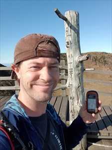
To get credit for finding Jeju’s Hallasan earthcache you must email me the correct answers to the below questions and post the required photo.
The photo must include one of the following two;
- You with this dead tree.
This is how it's done.
- An object with your geocaching name handwritten on it with this dead tree. Do not photoshop your name into the photo.
The email must include the answers to the below three Questions.
- Eruptions of what two types of lava built the island above sea level? (name the two types of lava)
- The two most recent eruptions occurred on the flanks of the mountain in
? and ? . (name the both years of the eruptions)
- More than 360 small ? that dot the island.
Any logs that does not have the required photo will be deleted without notice. No excuses/reasons will be accepted, just simply log this earthcache when you have a photo to include into your log and then email answers. Do not log a find without it. This is how it's done.
See below waypoint to the Seongpanak Trailhead.
What To Bring: Water, food and sunscreen are essentials any time of year. You can fill your water bottles at several natural springs. Some may find a hat and sunglasses helpful to fight the glare. Bring a light poncho in the summer. In the winter months (late November to March) you may also need hinged or semi-rigid crampons. Basic strap-on crampons are sold at the trailheads for $8. Hiking boots are recommended, though running shoes should suffice. |
Additional Hints
(Decrypt)
Gur qrnq gerr vf ybpngrq ba gur irel gbc bs Zg. Unyynfna.