|
   |
|
|
| Map |
 |
| Budapest |
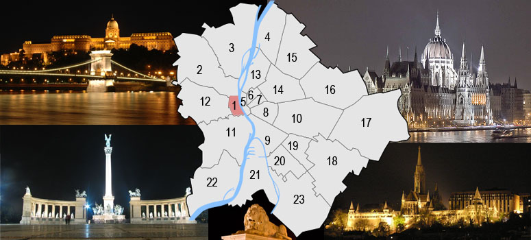
Budapest is a city of multiple characters, different geographical areas and of wide variety of architectural styles. The current city was established on 17th November, 1873 by the unification of the settlements of Pest, Buda and Óbuda on the banks of the Danube river. Budapest had 10 districts after coming into existence in 1873, numbered 1 to 10. In the 1930s, 4 new districts were organized, numbered 11 to 14. On 1st January, 1950, Budapest was united with 7 neighbouring towns and 16 villages, hence the number of its districts increased to 22. In 1994, one of the former villages left district 20 in order to form the 23rd district. Budapest's current 23 districts extend to an area of 525 square kilometres (202.7 sq mi). Most of the districts have a special flavour - from a posh downtown area one can get easily into the hilly districts of Buda or to the green suburbs of Pest. Several districts still bear the marks of the enforced industrialization of the 50s and 60s. City parks, forests of the Buda Hills, boat-houses along the Danube, flowery islands, shipyards and chemical plants, the Royal Castle and prefab housing estates are all part of this wonderful city.
The Great Budapest Geocaching Adventure guides you through all 23 districts with the goal of displaying the most typical or most unique sites in each of them. In each cache there is a code you need to uncover for the real coordinates of the bonus cache. You can find the codes on the inside of the lids of each cache container and in the logbooks. Happy caching. |
| 1st district |
| Budapest's 1st district hasn’t received its number by chance as the city has been born on the Castlehill, it was the centre of the country for centuries. All Budapesters think about the Castle if this district is mentioned, in spite of other sights are also belonging to it. At the time of the union this was the largest district of the capital, today this is the smallest though. Tabán (the Watercity), a big part of Krisztinaváros and the north of Gellért Hill also belong to the 1st district. It has an area of 3.4 km2, has 35000 residents and 17000 flats. The green areas extend only to 757000 m2. From the north it is bordered by the 2nd, from the west the 12th, from the south the 11th district and its eastern border is the Danube. |
 |
|
|
| The hiding place |
| The Fisherman's Bastion (Halászbástya) is a terrace built in neo-Gothic and neo-Romanesque style situated next to the Matthias Church on the Buda bank of the Danube, on the Castle Hill. It’s been designed and built between 1895 and 1902 according to the plans of Frigyes Schulek. Between 1947–48, János Schulek, son of Frigyes Schulek, led the restoration project after it’s been damaged during World War II. From the towers and the terrace you’ll have panoramic view of the Danube, Margaret Island, Gellért Hill and the entire of Pest. Its seven towers represent the seven Hungarian tribes settled down in the Carpathian Basin in 896. The Bastion is named after the guild of fishermen which was responsible for defending this stretch of the city walls in the Middle Ages. A bronze equestrian statue of King Stephen I erected in 1906 is standing by the Bastion. The pedestal that illustrates episodes of the King’s life was made by Alajos Stróbl in Neo-Romanesque style, based on the plans of Frigyes Schulek. |
| Approaching |
 with bus 16A or 116 (visit link). with bus 16A or 116 (visit link).
 with bicycle (visit link) with bicycle (visit link)
 There is no parking place for free There is no parking place for free
|
| Budapest |
| Budapest ist eine Stadt bunten Charakters, unterschiedlicher geographischer Zonen und einer breiten Vielfalt an architektonischen Stilen. Die heutige Stadt wurde am 17. November 1873 durch Zusammenschluss der Städte Pest, Buda und Óbuda, die an beiden Ufern der Doanu liegen, gegründet. Budapest hatte damals 10 Bezirke, nummeriert von 1 bis 10. In den 30er-Jahren kamen 4 weitere Bezirke (11-14) hinzu. Am 1.Jänner 1950 wurde das Stadtgebiet um angrenzende 7 Städte und 16 Dörfer erweitert, die Zahl der Bezirke erhöhte sich damit auf 22. 1994 wurde eines der früheren Dörfer aus dem 20. Bezirk ausgegliedert, womit ein neuer 23. Bezirk enstand. Die derzeit 23 Bezirke haben eine Ausdehnung von insgesamt etwa 525km² (202,7mi²). Die meisten dieser Bezirke haben ihren unverwechselbaren Charakter - von repräsentativen Innenstadtbereichen über die hügeligen Bezirke von Buda bis hin zu den erholsamen grünen Vorstädten von Pest ist alles zu finden. Einige Bezirke stehen bis heute im Zeichen der stark forcierten Industrialisierung der 50er- und 60er-Jahre. Stadtparks, die Wälder der Budaer Berge, Bootshäuser entlang der Donauufer, blütengezierte Inseln, Werften und Chemiebetriebe, die königliche Burg und auch Fertigteil Wohnhausanlagen sind alle Teil dieser wundervollen Stadt. Das Große Budapester Geocaching Abenteuer wird durch jeden der 23 Bezirke führen und versuchen, in jedem etwas Typisches oder Einzigartiges zu zeigen. Jedem, der alle 23 Caches besucht, winkt als Draufgabe ein BONUS-Cache. Viel spass. |
| 1 Bezirk |
| Dieser bezirk hat nicht zufällig diese Nummer bekommen, da die Stadt hier, an dem Budauer Burgberg geboren wurde, und war über Jahrhunderten das Zentrum des Landes. Wenn es sich um dieses Bezirk handelt, fält jedem Budapester der Burg ein, troztdem daß auch anderer Stadtteilen dazu gehören. Bei der Zusammenlegung war er der größte Bezirk der Stadt, heute ist aber nur der kleinste. Es befindet sich hier außer der Burg die Taban (die Wasserstadt), die größter Teil von der Krisztinastadt und die nördische Teil vom Gellert-Berg. Er ist 3,4 Km2 groß, hat 35000 Einwohner und 17000 Wohnungen. Er hat nur wenige Parken mit 757000 m2. Nordlich ist von dem 2-ten, westlich vom 12-ten, südlich vom 11-ten und ostlich von der Donau begrenzt. |
|
| Das Versteck |
| Die Fischerbastei ist ein von Frigyes Schulek von 1895 bis 1902 errichtetes, neoromanisches Monument in der ungarischen Hauptstadt Budapest. Es erhebt sich auf dem Burgberg an der Stelle des mittelalterlichen Fischmarkts von Buda. Der Name stammt von einer Fischergilde, für die das Monument errichtet wurde. Diese Gilde hatte im Mittelalter diesen Abschnitt der Stadtmauer zu verteidigen. Das skurrile Bauwerk, das mit seinen konischen Türmen an die Zelte der Magyaren erinnern soll, wird als Aussichtsterrasse auf Donau und Pest genutzt. Vor der Bastei steht eine Reiterstatue aus Bronze des heiligen Stephan, des Königs, der das Christentum in Ungarn verbreitete. 1906 wurde sie vom Bildhauer Alajos Stróbl entworfen und gefertigt. Das Postament, worauf die Statue ruht, wurde ebenfalls nach Plänen von Frigyes Schulek im neoromansichen Stil errichtet. Es ist mit Zierelementen geschmückt, die das Leben von König Stephan darstellen. Gleichfalls in unmittelbarer Nähe befindlich ist die überwiegend neogotische Matthiaskirche. weitere info: |
| Verkehrsverbindung |
mit dem Bus 16A, 116(visit link).
Radweg: (visit link)
Es gibt da nur Kurzparkzone
|
| Budapest |
| Budapest ezerarcú város, melyet földrajzi változatossága és építészeti sokszínüsége varázsol egyedivé. Az 1873. november 17-én Pest, Buda és Óbuda egyesítésével létrejött akkori fövárosnak 10 kerülete volt, amely az elkövetkezö évtizedek során fokozatosan bövült a mai 23-ra. A város ma 525 négyzetkilométeren terül el. A különbözö kerületek a folyamatos fejlödés és átalakulás mellett tovább örzik sajátosságaikat, a Belváros csillogó bevásárló utcái, Buda dombvidéke vagy a pesti zöldövezet lakónegyedei mind sajátos hangulattal bírnak. A város arcát továbbra is sebhelyként csúfítják az 50-es, 60-as évek eröltetett iparosításának "emlékmüvei". Zöld parkok és ligetek, a Budai hegyvidék erdöi, Duna-parti csónakházak, virágos szigetek, hajógyárak és vegyi üzemek, a Budavári palota és panel lakótelepek - ez mind Budapest. A Nagy Budapesti Geocaching Kaland végigvezet mind a 23 kerületen, bemutatva az adott városrész legjellegzetesebb vagy éppen a legfurcsább vonását Ha mind a 23 ládát megtalálod, indulhatsz a BONUS láda megkeresésére. Kalandra fel! |
| 1. kerület |
| Budapest I. kerülete nem véletlenül kapta ezt a sorszámot, hiszen itt - a Budai Várhegyen - született meg a város, itt volt évszázadokon át az ország központja. Ma is minden budapestinek a Vár jut az eszébe, ha a kerületrol esik szó, annak ellenére, hogy más városrészekkel is találkozhatunk benne. Az egyesítéskor még a föváros legnagyobb kerülete volt, mára azonban az egyik legkisebbé vált. A Váron kívül itt található a Tabán, a Víziváros és a Krisztinaváros legnagyobb része, valamint a Gellért-hegy északi része is. Területe 3,4 négyzetkilométer, lakosainak száma mintegy 35 000, az itteni lakások száma pedig 17 000. Területi elhelyezkedésénél fogva aránylag kevés benne a parkok száma, a 757 ezer négyzetméternyi gondozott zöld felülettel a középmezönyben helyezkedik el a kerületek között. Északon a II., nyugatról a XII., délröl a XI. kerülettel határos, míg keletröl a Duna választja el a föváros többi részétöl. |
|
| A rejtek |
| A Halászbástya Budapest egyik legismertebb müemléke, amely a budai várban, Budapest I. kerületében található. A neoromán kilátóteraszokról látható páratlan budapesti panoráma miatt a legjelentösebb idegenforgalmi látványosságok közé tartozik. A Halászbástya Dunával párhuzamos föhomlokzata mintegy 140 méter hosszúságú, amelyböl a déli folyosószárny hossza mintegy 40 m, az északié 65 m, míg a díszes középsö mellvédfal 35 m hosszú. Csúcsos süvegü kötornyai a hét magyar honfoglaló vezért szimbolizálják. A régi budai várfalak helyén a Mátyás-templom átépítésével is megbízott Schulek Frigyes tervei alapján épült 1895 és 1902 között, neoromán stílusban. A neve arra utal, hogy a középkorban a várfalnak ezt a részét a halászok céhe védte. 1947–48-ban Schulek Frigyes fia, Schulek János vezette a második világháborúban megrongálódott épületegyüttes helyreállítását. Március 15-töl október 15-ig, reggel 9-töl este 11 óráig belépö ellenében, más idöpontban szabadon látogatható! bovebb info: |
| Megközelítés |
16A vagy 116-os busszal. (menetrend).
Kerékpárral (térkép)
a környéken fizetös parkolóban tudsz csak megállni
|