Located just a short hike down from the Ice Age Trail, you will
find the hidden kettle pond of Lapham Peak State Park. Closest
parking is at the top of the peak under the observation tower, then
head down the steps to the Ice Ace Trail. Be prepared for some
significant elevation change heading down to the pond, then
climbing back up to the peak. Because this is in a state park, a
daily or yearly permit is required.
About 20,000 years ago, two lobes of the Wisconsinan Glacier,
the Green Bay lobe and the Lake Michigan lobe, met along a line
extending from Walworth to Kewaunee County. In the encounter, large
blocks of ice were broken off and buried in the glacial deposit or
"till". So envision this block of ice sitting there under all this
debris starting to melt as the climate warms. The sediment on top
settles down as the ice disappears, forming a steep-sided
depression in the earth. This is now a "kettle", which was named
for the kettle pots used for cooking by pioneers.
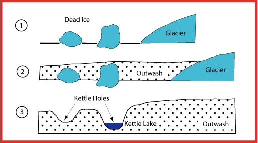
When the bottom of a kettle lies below the ground water table, a
permanent pond or lake will form. In other cases, a kettle might
contain what is known as an ephemeral pool which appears after the
winter melt and spring rains, but disappears later in the year. Yet
other kettles remain dry year round. This particular kettle
contains a permanent shallow pond full of aquatic vegetation and is
an excellent habitat for reptiles and amphibians.
To claim this earthcache, you must complete these
tasks.
1. Hike the Ice Age Trail until you reach the additional coords
"Side Trail to Pond" (N43 01.789 W88 23.113). Make note of the
man-made structure there, then descend down the small side trail to
the bottom of the kettle.
2. Use your GPSr to determine the width of the kettle pond.
3. BRING YOUR DIGITAL CAMERA. Take a picture of yourself or your
GPS in front of the pond and post this picture with your log.
4. Contact me through my profile and send me a message with these
two pieces of information: the pond width that you measured and
what the man-made structure is. Do this at the same time you post
your log.
This earthcache is an "Ice Age Trail Cold Cache" and should
only be accessed from the Ice Age Trail. Do not hike on groomed
cross-country ski trails in this park during the winter. The
Geocache Notification Form has been submitted to Ed Musik, Lapham
Peak Property Manager, Wisconsin DNR. Geocaches placed on Wisconsin
Department of Natural Resource managed lands require permission by
means of a notification form. Please print out a paper copy of the
notification form, fill in all required information, then submit it
to the land manager. The DNR Notification form and land manager
information can be obtained at: http://www.wi-geocaching.com/hiding
.
Sources:
www.dnr.state.wi.us/org/land/parks/specific/kmscenicdrive/forestgeology.html
www.fettes.com/cairngorms/kettle%20hole.htm
www.physicalgeography.net