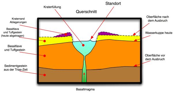
Dieser Cache beschäftigt sich mit den Überresten eines Vulkans in der Hochrhön.
Dieser Landstrich war das Zentrum der vulkanischen Aktivität im Tertiär.
Die vulkanischen Laven bildeten damals hier eine relativ ebene große Fläche.
Am Standort Fliegerdenkmal befindet sich zusätzlich zu diesen Laven der Überrest eines Vulkanschlotes.
Dieser Rest bildet hier eine natürliche Felsenklippe, die für das Denkmal
mit basaltischen Felsblöcken aus der Umgebung ergänzt wurden.
Diese Felsblöcke haben viele Löcher, die zum Teil noch mit grob
strukturiertem grünen Gestein gefüllt sind, das allerdings rasch verwittert.
Das grüne Gestein ist Olivin. Das sind Bruchstücke des Erdmantels,
die nur eine schnell aufsteigende basaltische Schmelze
mit an die Oberfläche bringen konnte.
Das Olivin liegt hier in Form von Olivinknollen vor,
die in den Basalt eingeschlossen sind.
Bitte beantworte folgende Fragen:
In welcher Zeit ist die basaltische Schmelze mit dem Olivin aufgestiegen?
Aus welcher maximalen Tiefe kommt das Olivin?
Ein Foto vom Fliegerdenkmal im Hintergrund.
Messe bei den Koordinaten den Duchmesser und die Tiefe des runden Einschlussloches.
(Das Loch ist an einer großen Basaltsäule mit grauen Flechten)(N50° 29.881 E9° 55.981)
Es darf direkt geloggt werden. Bei Unstimmigkeiten melden wir uns.
This cache deals with the remains of a volcano in the Hochrhoen.
This region has been the centre of the volcanic activity in the Tertiary period.
The volcanic lava flows have formed a comparatively even great plain here.
At the position of this earthcache, at the airmen´s memorial on the Mount Wasserkuppe,
there is something more than these lava flows.
Here you can find the relict of a volcanic vent. The relict forms a natural cliff,
which has been enlarged by basaltic lumps of rock from
the surrounding area (in order to form a larger monument).
The basaltic lumps of the monument have got many holes.
The holes are partly filled with a rough-textured green rock
which wheathers away rapidly.
This green rock is olivine.
The olivine parts are fragments from the mantle of the earth.
Only a quickly rising basaltic flow has been able to bring
these fragments to earth´s surface. The olivine is existent
here in the form of olivine lumps or nodules
which are inclusions in the basaltic rocks.
Please answer the following questions:
In which time has the basaltic flow with the olivine risen?
From which maximal depth stems the olivine?
A picture of the memorial in the background.
At the following coordinates take the measurement of diameter and depth of the round inclusion hole.
(The hole is in a great basalt stack with grey lichen on it.)(N50° 29.881 E9° 55.981)