Around Christmas 2009, seismic activity began around the Eyjafjallajökull volcano area, with thousands of small earthquakes (mostly magnitude 1–2 on the Richter magnitude scale) 7–10 kilometres beneath the volcano. On 26 February 2010, the GPS navigation tools used by the Meteorological Institute of Iceland at Þorvaldseyri farm in the Eyjafjöll area (around 15 kilometres southeast of the location of the recent eruption) had shown 3 centimetres displacement of the local earth crust in a southward direction, of which a 1 centimetre displacement took place within four days. This unusual seismic activity along with that rapid expansion of the earth's crust gave geophysicists evidence that magma were pouring from underneath the crust into the magma chamber of the Eyjafjallajökull volcano and that pressure stemming from the process caused the huge crustal displacement at Þorvaldseyri farm. The seismic activity continued to increase and from March 3 to 5, close to 3,000 earthquakes were measured at the epicentre in the volcano. Most were too small (magnitude 2 on Richter scale) to be read as presaging an eruption, but some could be detected in nearby towns. The eruption is thought to have begun on 20 March 2010, sometime between 10:30 pm and 11:30 pm local time (UTC), a few kilometres east of the glacier in the northern slopes of Fimmvörðuháls mountain pass.
About 500 farmers and their families from the areas of Fljótshlíð, Eyjafjöll, and Landeyjar were evacuated overnight, and flights to and from Reykjavík and Keflavík International Airport were postponed, but in the evening of 21 March, domestic and international air traffic was allowed again. Inhabitants of the risk zone of Fljótshlíð, Eyjafjöll, and Landeyjar area were allowed to return to their farms and homes after an evening meeting with the Civil Protection Department on 22 March and the evacuation plan was temporarily dismissed. Instead, the police closed the road to Þórsmörk, and the jeep trail from Skógar village to Fimmvörðuháls mountain pass, but these roads and trails were reopened on 29 March, only though for suitable jeeps, however when the second fissure appeared the road was closed again because of the danger of flash floods, which could have been the case if the fissure had opened near big ice caps or other snow reservoirs, but the road was again opened at around noon of the 1 April.
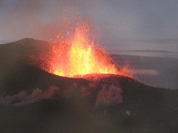
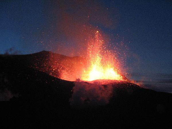
The fissure is 500 metres long pointing northeast–southwest, with 10–12 erupting lava craters which spew around 1,000 °C (1,832 °F) hot lava up to 150 metres into the air. The lava is alkaline and viscous so the motion of the lava stream to the west and east of the fissure is slow, so this makes it a typical effusive eruption. The molten lava has flowed more than 4000 metres to the northeast of the fissures, and into Hrunagil canyon, forming a more than 200 meter (620 ft) long "lava"-fall and is slowly approaching Þórsmörk on a slow rate, but has not yet reached the flood plains of Krossá. On 25 March 2010, scientists witnessed on location, for the first time in history, the formation of a pseudocrater during a steam explosion, while studying the eruption. Crustal expansion continued at Þorvaldseyri for two days after the eruption began, but has been slowly decreasing, along with increasing volcanic activity, indicating that the input of magma into the magma chamber of the volcano is roughly equal to the magma output out of the eruption, giving evidence that this volcanic activity has reached equilibrium. A new fissure opened around 19:00 UTC local time (7 pm) on 31 March, around 200 meters northwest of the original fissure. Many witnesses were present while the new fissure opened. It is a bit smaller, around 300 meter long according to witnesses, and lava coming from it has now started to flow into Hvannárgil canyon. These two erupting fissures share the same magma chamber according to geophysicists. No unusual seismic activity was detected at the time the new fissure appeared, nor any crustal expansion according to many seismometers and GPS recorders situated in nearby areas.
Geophysicist Magnús Tumi Einarsson said (at a press meeting in Hvolsvöllur on 21 March 2010) that this eruption is small compared to, for example, the eruption of Hekla in 2000. The eruption, rather than taking place under the ice cap of the glacier, occurred in the mountain pass between the Eyjafjallajökull and Mýrdalsjökull glaciers. As long as the fissure is not near the glacier, the risk of flooding is minimal; however, the fissure could extend into the ice cap thereby greatly increasing the risk of flooding. The radar stations of the Meteorological Institute of Iceland did not detect any appreciable amount of volcanic ashfall during the first 24 hours of the eruption. However, during the night of 22 March 2010, they reported some volcanic ash fall reaching the Fljótshlíð area (20–25 kilometres northwest of the eruption's location) and Hvolsvöllur town (40 kilometres northwest of the eruption location) leaving vehicles with a fine grey layer of volcanic ash. At around 7 am on 22 March, an explosion launched eruption columns as far as 4 kilometres straight up into the air. This was the highest plume since the eruption started. At 08:30 UTC local time on 23 March 2010, a small vapour explosion took place, when hot magma came into contact with nearby snowdrifts, omitting a huge vapour plume which reached an altitude of 7 kilometres, and were detected on radars from the Meteorological Institute of Iceland. Since than many vapour explosions have taken place.
Samples of volcanic ash collected near the eruption showed the concentration of water-soluble fluoride is 1/3 of the concentration typical in Hekla eruptions, with a mean value of 104 milligrams of fluoride per kilogram of ash. Farmers in nearby locations have been warned not to let their livestock drink from local ponds and streams as high concentrations of fluoride can have deadly renal and hepatic effects in livestock (particularly sheep), but agriculture remains important in this region of Iceland.
On 14 April, 2010, Eyjafjallajökull resumed erupting after a brief pause, this time in the centre of the glacier, causing meltwater floods to rush down nearby rivers in two flows on either side of the volcano, and requiring 800 people to be evacuated. The road along the Markarfljót river had been washed away in several places.
Unlike the earlier eruption, the second eruption occurred beneath glacial ice. Cold water from melted ice chills the lava quickly and fragments it into glass, creating small glass particles that get carried into the eruption plume. This, together with the magnitude of the eruption, estimated to be ten to twenty times larger than that on Fimmvörðuháls on 20 March, created a glass-rich plume in the upper atmosphere, which is very hazardous to aircraft.
Source: Wikipedia
The coordinates will take you to a place close to the first eruption, from which you have a good point of view.
Note! The surroundings may have changed since my visit. Always use common sense and do not go closer to the volcano than safety allows! It is not required that the photo is taken at the exact coordinates, but only with the volcano in the background.
In order to validate the found log you must:
1) Take a picture of yourself, with your GPS receiver, with the volcanic eruption visible in the background, (Or if/when the eruption has subsided, what is left of the crater) and attach to your log.
2) Send an E-mail via my profile e-mail, with the answers to the following questions:
* How many times, and when, has there been vulcanic activity at Eyjafjallajökull for the last 1100 years?
*East of Eyjafjallajökull, there is a big, for the moment inactive, subglacial volcano. What is the name of this volcano?
3) Try to find a small piece of hardened lava, the closer to the eruption the better. Back home, estimate the size (volume) of the piece of lava rock, and the weight. Use theese two values to calculate the density of the rock, and include all the three values in the e-mail. If your value seems abnormal, can you think of any thinkable reason why?
The e-mail to the owner can be sent in any desired of the below languages:
English
French
Danish
Swedish
Scanian
Update: Because of a change in the guidelines for earthcaches, hiders are no longer encouraged to demand a photo as an evidence for visiting the place. On the opposite it is now forbidden to demand a photo as evidence. Therefore, task one above is now opotional.
To get to the cache you can either walk the 10km from Skogafoss, or take an Icelandic Jeep over the glacier. Both of them are true experiences, I promise you!
If you decide to get here by foot, make sure you are properly dressed. It is cold up at the glacier!
If you need to rest along the road, there is a small cabin a bit before the eruption at an elevation of 900m above sea level.
I will accept logs that pre-dates the publishing of this cache, though the honor of FTF will be restricted to the first cacher to log after the date of publish.
Good Luck!