This cache is a 16-stage(!) Multi designed to provide what hopefully will be an interesting and amusing walk through downtown Campbell. The total distance is around 1.5 miles, but how long it takes will be dependent on your personal pace. Most finders report that it took them perhaps 45 minutes to complete, at a walking pace.
This cache will be most enjoyed by those who enjoy a nice walk with some interesting locations, preferably in the company of friends. For the numbers hound whose main concern is to add to their find count, there are ample opportunities to shortcut or brute force this, allowing you to skip the experience as much as possible.
This cache is based loosely on the two Campbell Historic Downtown Walking Tour pamphlets from the Campbell Historic Preservation Board. I've been meaning to do put this Multi together for almost two years now, because I enjoy small, old downtowns like this one, and the historic and other interesting sights along the way. I hope you do too.
Those of you who remember Locationless caches will have the opportunity to see several different ones on this tour. I counted at least four.
Completing this cache
This cache will be best during the day, with ample time to complete it. There are restrooms, water fountains, shops and restaurants along the way. It's all on flat ground except for one set of stairs.
You'll want to print out this listing, or have it loaded up in CacheMate, a web browser, or other convenient doohicky. Be warned that some people have found that their GPS or PDA didn't hold all of the waypoints, so I suggest you verify that you have them all. If you like a bit of a safety net, a digital camera where you can review your photos on the LCD might save you from backtracking if you make an error on a stage.
The Multi begins outside a restaurant which is a popular location for geocaching Events and GBA "unevents", and the 1.5 mile distance is based on making a loop and returning to roughly the same point at the end.
This cache should be fine for children that can handle the distance and duration. You should be able to complete this cache with a dog, stroller, or on bicycle, although you may have to walk the bike briefly at one point, or carry a very young kid up the short stairs. It's technically wheelchair accessible the whole way, but you would need to locate an alternate route or two.
Enough of these preliminaries. It's time for...
The Stages
1: N37 17.217' W121 56.769' Start on the corner by the aforementioned restaurant which has hosted many local geocaching events. There in the sidewalk you'll find one of many of the agricultural heritage plaques which were placed in 1992. Above the words "City of Campbell" you'll find a few other words on this plaque. Count those words for A.
2: N37 17.218' W121 56.704' A Campbell Historical Location plaque outside the Country Woman's Club. This is a Spanish Revival building, built in the 1920s. The club assisted with cultural programs, the first town library (from 1907 to the 1960s), and started the Campbell Historical Museum. They sold this building in 1972.
Count the number of letters in the last word on the plaque. That number is B.
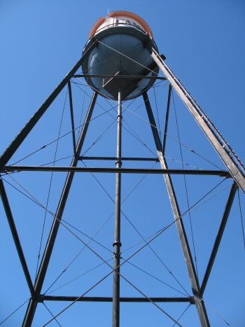
3: N37 17.158' W121 56.680' This 130' water tank was built in 1928 and is the last of a series of tanks here, including two wooden tanks which fell in the great 1906 earthquake. This one has a capacity of 75,000 gallons. Take a moment to look up at the tank from under it. Then notice the old pump building next to the tower. There is a plaque by the front door. The third of the six numerals on the plaque is C.
4: N37 17.153' W121 56.621' Another plaque, this one surrounded by flowers, at the entrance to a newer plaza. A huge fruit canning and drying facility once stood here. There were sixteen acres of drying yards, which made it one of the world's largest fruit drying facilities. The facility had over 700 employees back in 1887, soon after it was founded by the Flemming brothers. Find the year the plant closed, and the third digit of that year is D.
5: N37 17.098' W121 56.652' From the previous location you can walk through the Water Tower Plaza's central walkway, if it is open (otherwise you'll have to go around.) There are some interesting things along the way, including this wonderful water fountain:
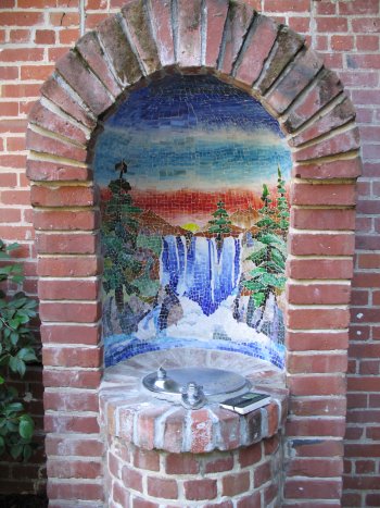
It's even got cute little steps for the kids.
Continuing on, walk through the building and up to the parking area. This location is now part of local geocaching lore and will be familiar to many local cachers who attended the Venona event back in 2006 I think it was. Check out the old business name painted on the side of the building, and tell me that this spot doesn't need to be part of a geocache!!! :) See the year? Subtract 1907 to get E.
6: N37 17.219' W121 56.622' Here you'll find yourself at a cafe which is in the old First bank of Campbell building, built in 1911 in the Italian Renaissance Revival style. Looking up, you'll see pairs of green-painted decorative supports just below the roof level. Count how many pairs there are (on both the east and north sides of the building) and the square root of that number is F.
7: N37 17.228' W121 56.605' On the diagonal opposite corner you come to the oldest commercial building in Campbell. Also in Renaissance Revival style, this brick building was built in 1895, and it looks just great for its age. Campbell's first bank was incorporated and housed in this building the following year. Known locally as the Farley Building, the third digit of the year that Guy Farley purchased it is G
8: N37 17.267' W121 56.626' This is the current home of the Campbell Historical Museum and is housed in Campbell's first municipal-owned building. It later served as a city office, including the town council chambers. There's a number in the top line of the plaque for the old Fire House here, and that number is H.
9: N37 17.283' W121 56.618' This is the first of several stages in the Orchard City Green area. From here you'll also see the library, city hall, and an unusual clock tower. There's also a very cool building straight ahead, but we'll get to that one in a minute. Here you'll find yet another plaque, this one memorializing a much more recent event in our nation's history. You may wish to take a moment to remember the events before moving on... Find the infamous date on the plaque. Take the day of the month, and add the two digits together to get J.
10: N37 17.294' W121 56.620' Remember the agricultural history plaque at stage one? Perhaps you have noticed others along the way. Here, you can see one of each of the variations in one place. Each bears the name of a nut or fruit. Subtract the number of nut plaques from the number of fruit plaques, and subtract three to get K.
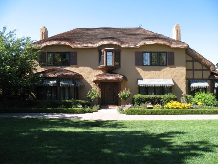
11: N37 17.319' W121 56.617' Wow, look at this place. Architecturally, this is obviously in the Tudor Revival style. It was built for English immigrant John Colpitts Ainsley in 1925. A Campbell Historical plaque is clearly not sufficient here, so this is on the National Register of Historic Places, with an accordingly fancy plaque. Ainsley's granddaughters donated the house to the city of Campbell. Unusually, both of them had the same middle name. The number of letters in that middle name gets you L.
12: N37 17.257' W121 56.647' Now you're at the other side of a building you visited earlier, and the site of another geocache. Among the other things inside the tiny museum is a large wooden bench, built from a tree that Theodore Roosevelt had planted at the corner of Campbell Ave. and Winchester Blvd. in 1903.
Speaking of trees, you'll see a large slice of tree on its side here, with mysterious numbers on its face... The numbers represent the centuries of growth! The number that's closest to the 12 is M.
13: N37 17.260' W121 56.844' You have a little bit longer of a walk to this stage, because there's not much of interest on the way. When you get there, you get to a popular parking structure for geocachers. Another Venona event concluded here, with a lot of laughter I might add. There used to be a cache in there too.
As you approach this structure, you may notice some artwork on the east side. This stage is at the matching art on the west side of the building. The middle piece represents an earlier stage of this Multi. Count the number of leaves which seem to be hanging from a five hundred foot tree ;) at the top of the artwork. Subtract six and you have N.
14: N37 17.265' W121 56.853' We can't talk about the history of any town in Silicon Valley without mentioning the modern tech era. Unfortunately, the tech company that used to be here is apparently gone. They had a back door here they didn't want you to use, so it was labeled with a "404 not found" error. :) Now that you know what the message here was, just add those three digits in "404" together and add one for P.
15: N37 17.247' W121 56.935' At last, the penultimate stage! Find this last blasted plaque and you'll have the final coordinates. You'll find this one between a fantastic tree and another really nice building. They don't build grammar schools like this anymore! It was used until the 1960s. Find the year this one was built, and add the last two digits of the year together. Subtract one from that for Q.
FINAL CACHE LOCATION
The camo micro is located at North AB CD.EFG' West HJK LM.NPQ'. There is another plaque here, of a national type, but this one is obviously unique to Campbell. The cache is right underneath it and should blend in reasonably well. Please do not trample the plants or I'll have to move the cache and rework the answers, and no one wants that LOL.
I hope you enjoyed your tour!