Drumlins
Drumlins are formed of till. They are elongated features that
can reach a kilometer or more in length, 500m or so in width and
over 50m in height. One end is quite step, whilst the other end
tapers away to ground level. The Stoss end is the steeper of the
two ends and used to face into the ice flow.
The Lee slope is the gentler slope and becomes lower as you move
away from the source of the ice. This means that the highest point
will always be at the Stoss end of the drumlin, and the lowest
point will be the end of the Lee slope. It is common to find
several drumlins grouped together. The collection of drumlins is
called a swarm. Areas with swarms of drumlins are sometimes
referred to as 'basket of eggs' topography because of the rounded
bumps that remind people of a box containing eggs.
There is still some debate about how drumlins are formed, but
the most widely accepted idea is that they were formed when the ice
became overloaded with sediment. When the competence of the glacier
was reduced, material was deposited, in the same way that a river
overloaded with sediment deposits the excess material. The glacier
may have experienced a reduction in its competence for several
reasons, including melting of the ice and changes in velocity. If
there is a small obstacle on the ground, this may act as a trigger
point and till will build up around it.
It is difficult to understand how the material could have been
directly deposited in the characteristic shape of a drumlin unless
the ice was still moving at the time, but it may also have been
reshaped by further ice movements after it was deposited.
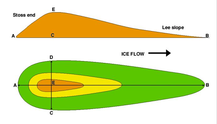 Plan and profile diagrams of a typical drumlin
In the diagram above, the ice was flowing from left to right.
The long axis of the drumlin is the line A-B, the point of maximum
width is the line C-D, and the highest point on the landform is at
E. Not all drumlins will show such a distinct difference in slope
angle between the stoss end and lee slope, but the stoss end will
always be the steeper of the two
There is no requirement to go inside the fortress to log this
cache, however it is highly recommended as its history and daily
shows are fantastic and will also give you spectacular views.
To log this cache you must "WALK" the perimeter of the fortress
along the gravel walking path beside the road and determine the
following answers:
1. Reset your GPS odometer and calculate how many meters it
takes you to walk from the start point around the perimeter of the
fortress and return to the start point.
,(START POINT IS THE CO-ORDS at the TOP of this page. Not the
CO-ORDS in #2)
2. DELETED, Item no longer on site.
3. How high above sea level is the Citadel Drumlin?
4. How much height has the Drumlin lost due to the construction
of the fortresses and how many fortresses have been atop this
drumlin?
Please take a picture of yourself holding your GPS at the start
point!!!
E-MAIL me the answers for the above questions. Do Not Post them in
your log entry. *** You may log the find at any time but logs that
do not satisfy the above questions will be deleted ***
For more information visit
http://www.gov.ns.ca/natr/meb/field/stop1.htm#stop1
http://www.geography-site.co.uk/pages/physical/glaciers/drum.html
http://www.pc.gc.ca/lhn-nhs/ns/halifax/visit/index_e.asp