To ensure you enjoy your state park experience, be aware of the natural world. There are some areas which are potentially hazardous to all visitors. Since it is impractical to post signs at all danger points, use caution when approaching such areas as cliffs, caves, heavily wooded areas, swamps, streams, and lakes. Adults are responsible for children in their care. If unsure about possible hazards, check at the visitor center.
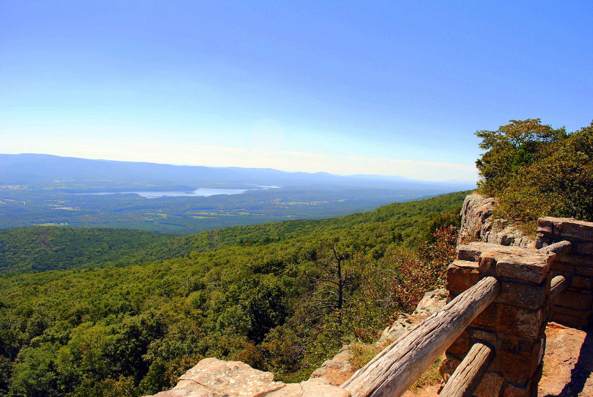
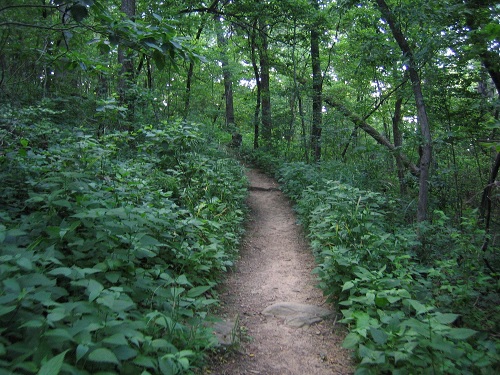
The trail is 1.5 miles long. For a Trail map click HERE
The trail looks like this for parts of the trip
Local geology:
A Physiographic Region is a region of which all parts are similar in geologic structure and climate and which has consequently had a unified geomorphic history; a region whose patterns of relief features or landforms differs significantly from that of adjacent regions. The Ouachita Mountains are a physiographic section of the larger Ouachita province (which includes both the Ouachita Mountains and the Arkansas Valley), which in turn is part of the larger Interior Highlands physiographic division. The Ouachita Mountains form one of the few major mountainous regions between the Rocky Mountains and the Appalachian Mountains. The highest peak in the Ouachitas is Mount Magazine in west-central Arkansas. Unlike most other mountain ranges in the United States, the Ouachitas run east and west rather than north and south. Also, the Ouachitas are distinctive in that volcanism, metamorphism, and intrusions are notably absent throughout most of the system. The Ouachitas tend to be clustered into distinct sub-ranges separated by relatively broad valleys. The Ouachita Mountain Region consists of a series of sharp ridges, mostly east-west trending and often buckled and distorted, separated by narrow to broad valleys. Surface rocks from this region are mostly shales, sandstone, novaculite, chert and minor limestone. Mount Magazine is a flat-topped plateau with a sandstone cap rimmed by precipitous rock cliffs.
Throughout numerous ages, the surface of the land here has experienced intense change. The main event taking place time after time here has been erosion. Let’s go back many millions of years ago and walk through the process of the geologic account with the rock-making and the building of the mountains which took place in another time.
The mountain building process, called orogeny or orogenesis, created many folds, faults, and overturned layers of rock which make up these mountains. The fact of the matter is these mountains are old, very old. These mountains were in fact very tall much like the Rocky Mountains of western United States. Through millions of years of erosion these mountains have had a lot of their height eroded.
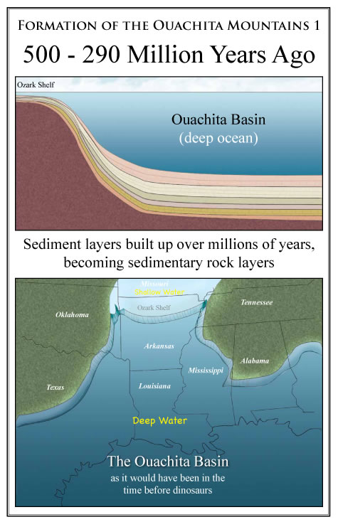
Image Source: http://www.rockhoundingar.com/ouamtns.php
The Ouachita Mountains are what’s called “Fold Mountains” and are very similar to the Appalachian Mountains on the eastern United States. Fold Mountains happen where oceanic crust meets less dense continental crust, the oceanic crust is forced under the continental crust. The continental crust is buckled by the impact, and fold mountains result. Back before the dinosaurs, Arkansas was on the shore of a deep ocean, called the Ouachita Basin.
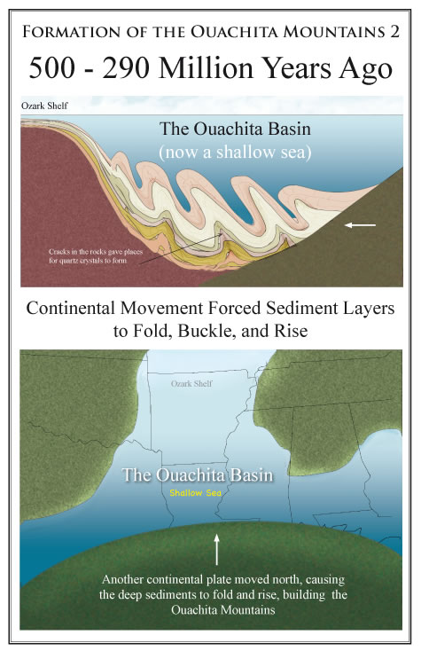
Image Source: http://www.rockhoundingar.com/ouamtns.php
The continental plates are always moving and back then the South America continental plate worked its way in. This caused the ocean to get smaller and smaller and the ocean floor had nowhere to go. All this pressure caused the ocean floor to buckle ripple and fold upwards. The ocean floor was made up of sediments and they were squeezed, rippled and folded, the brittle units faulted allowing other sediment to push over on top of them. Around the time the dinosaurs came around the whole plate movements and mountain building process had finished and Arkansas was now a shallow sea with a set of mountains protruding out of the water.
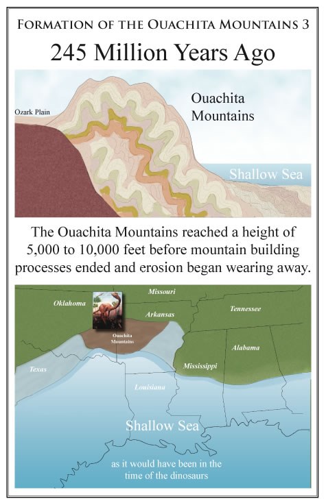
Image Source: http://www.rockhoundingar.com/ouamtns.php
Over the following millions of years erosion eroded away at the high mountains and washed it into the shallow seas below. This process filled the shallow seas up and over time that became rock and the shallow seas disappeared.
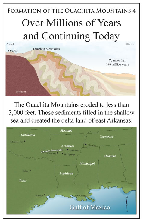
Image Source: http://www.rockhoundingar.com/ouamtns.php
Sources
**Logging requirements**
DO NOT POST ANSWERS IN YOUR LOG.
Send the following answers to me via email.
- The text "GC5FN7H Highest Point In Arkansas" on the first line
- Describe the top of this mountain, is it covered in dirt and soil or is rocky?
- what is the elevation up here?
- compare your elevation reading to the benchmark inlayed in the stone shaped like Arkansas, how much off are you? (no photo's of the benchmark please)
- At the top there is a 400 square foot shape made out of rocks what color are they?
- How was this mountain made? (looking for the exact name)
| I have earned GSA's highest level: |
 |