This geocaching adventure challenges you to visit each of Louisiana's State Parks and Historic Sites. Each State Park and Historic Site has a unique special mission with a story to tell, and offers its own very special geocaching adventure for you to experience. Each of these facilities has an official Geo Project cache, containing a special clue for you to find and record. These clues collectively will enable you to determine the coordinates of the mystery location of the Final Cache, which is located somewhere in the state of Louisiana. Use this Official LAOSP Clue Tracking Sheet to record all your clues.
As you travel our fine state, we encourage you to upload photos of your travels on the geocaching.com web pages. However, we ask that you please do not log clues or spoilers to the caches...they would have to be deleted to keep the game fun for everyone! Do tell us all about your travels and what you liked best about our parks and historic sites. As an extra incentive, and for a limited time, you can earn a Louisiana State Park Geocoin for visiting all of our State Parks and Historic Sites, and finding all the official geocaches placed for your pleasure! Prizes are limited to the supply in hand and will not be replenished.
Before you hunt for your first cache, click this link to read the rules for the Geo Project * Louisiana Office of State Parks. You must follow all the rules, to qualify to win one of these great prizes and collectibles.
This cache was place by the geocachers of Louisiana, on behalf of the Louisiana Office of State Parks. It is designed to bring your attention to these beautiful State Parks and Historic Sites. We ask that you join us by visiting them whenever you get a chance. Our State Park system is a great resource, so remember to "cache in and trash out".
Congratulations to SelgoJA FTF!
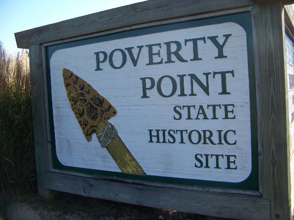
Poverty Point State Historic Site
6859 Highway 577, Pioneer, Louisiana 71266
 318-926-5492 or 888-926-5492
Email: povertypoint@crt.la.gov
Directions: From I-20, take the Delhi exit and travel north of LA 17, east on LA 134 and north on LA 577. GPS Coordinates: N 32 38.2500; W 91 24.4164.
Hours of Operation: 9 a.m. to 5 p.m., daily. Closed on Thanksgiving, Christmas and New Year's Day. Guided tours are offered daily.
Entrance Fees: $4 per person; free for seniors (62 and over) and for children age 12 and under. Groups are asked to call in advance.
Golden Age & Golden Access Passports (Available through the National Park Service. Click here for more information)
Visitors who hold a Golden Age or Golden Access Passport are entitled to a 50% reduction on camping fees at Louisiana State Parks. (Passport holders are allowed one site per passport).
It is recommended that anyone attempting the State Park Geo Project series should consider getting the Louisiana State Parks' $80 Annual Park Pass, which is valid for day use at all sites for the duration of a calendar year (i.e., January through December), and can be purchased at any state park. All people accompanying a permit holder as occupants of a single, private, non-commercial vehicle, in which the permit holder is a passenger or driver, are included in the Annual Pass admission.
Complete listing of available facilities and activities
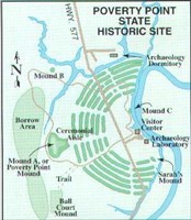
Trails at Poverty Point State Historic Site:
The time was eight centuries after Egyptian slaves dragged huge stones across the desert to build the Great Pyramids, and before the great Mayan pyramids were constructed. The place was a site in what is now northeastern Louisiana. The people were a highly civilized group who left behind one of the most important archaeological sites in North America.
The Poverty Point inhabitants, like the ancient Mayans, set for themselves an enormous task as they built a complex array of earthen mounds and ridges overlooking the Mississippi River flood plain. This accomplishment is particularly impressive for a pre-agricultural society. The central construction consists of six rows of concentric ridges, which at one time were five feet high. The five aisles and six sections of ridges form a partial octagon. The diameter of the outermost ridges measures three-quarters of a mile. It is thought that these ridges served as foundations for dwellings although little evidence of structures has been found. However, features and midden deposits uncovered during excavations support this theory.
Poverty Point's inhabitants imported certain essential supplies from great distances. Projectile points and other stone tools found at Poverty Point were made from raw materials which originated in the Ouachita and Ozark Mountains and in the Ohio and Tennessee River valleys. Soapstone for vessels came from the Appalachian foothills of northern Alabama and Georgia. Other materials came from distant places in the eastern United States. The extensive trade network attests to the complex and sophisticated society that built the Poverty Point earthworks.
 Poverty Point is indeed a rare remnant of an exceptional culture. It has been estimated that it took at least five million hours of labor to build the massive earthworks. Considering that the laborers carried this dirt to the site in baskets of about a 50-pound capacity, it is obvious that this was a great communal engineering feat. Dated between 1650 and 700 B.C., this site of more than 400 acres is unique among archaeological sites on this continent. In 1962, Poverty Point was designated a National Historic Landmark by the U.S. Department of the Interior. An interpretive museum, special events, programs and guided tours, highlight activities at the park. Tram tours are given daily at 9:30 a.m., 11 a.m., 12:30 p.m., 2 p.m. and 3:30, from March 1 through October 31.
For more information on the site, refer to Anthropological Study Series #7 -- Poverty Point: A Terminal Archaic Culture of the Lower Mississippi Valley -- prepared by the Louisiana Archaeological Survey and Antiquities Commission.
To view the video, Poverty Point Earthworks: Evolutionary Milestones of the Americas, on ArchaeologyChannel.org, click here; Windows Media Player or Real Player are needed for playback. Poverty Point Earthworks: Evolutionary Milestones of the Americas was produced by the Department of Culture, Recreation and Tourism; the Office of State Parks; and Louisiana Public Broadcasting (LPB).
Your Clues to this Cache...
Find it / Log it / Get Clue / Post Picture of You and Entrance Sign!
This Cache placed by blazikenfire36
Located near the small Northeast Louisiana town of Epps, Poverty Point State Historic Site protects the remains of one of the most astounding archaeological sites in the world. The prehistoric earthworks at Poverty Point are the largest in the western hemisphere, stretching more than 3/4 of a mile across. It takes a bit of imagination to see the Poverty Point site as it once appeared. 19th and 20th century agriculture greatly reduced the height of some of the earthworks before they were acquired and preserved by the State of Louisiana. The staff, however, does a phenomenal job of helping to bring this important archaeological site back to life.
There are certain restrictions that been placed here that must be adhered to by everyone. This park is an active archaeological site and therefore all park rules must be followed.
This is a multicache. The above coordinates will take you to the Museum/Visitors Center. Go there and tell the park staff that you are geocaching, and they will provide you with a map and the final stage coordinates. Twenty minutes should be sufficient time for finding this cache, so as long as you arrive by 4:40 PM, you should have plenty of time. The park closes its gates at 5:00 PM, and coming onto or staying inside the park during non business hours is strictly prohibited. This would be considered as trespassing and the violator will be subject to all local laws. After you have completed the cache, please stop back by the visitors center and let them know what you thought of the park and to thank them for allowing us the opportunity to place a cache here. As always, please respect the environment and remember to CITO (cache-in, trash-out).