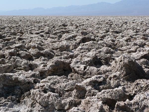
The Devil's Golf Course, located between Furnace Creek and Badwater, is a large salt pan in Death Valley National Park.
At least 150,000 years ago the present day salt pan was the site of a large, deep lake caused by snow and melting glaciers as far away as the Sierra Nevada. Known as LAKE MANLY, this body of water reached depths of 600’. During this period the majority of the salts that comprise this formation entered the area. At the close of the last Ice Age (about 10,000 years ago) climate change initiated a period of evaporation drying up this lake. Then for a brief period (2,000 to 3,000 years ago) the climate was again much wetter and another shallow lake existed formed primarily from snow melt in the surrounding mountains and the drainage of the Amargosa River. This time the salt pan flooded to a depth of about 30’ creating a Holocene Lake. Eventually the climate again became more desert like and the forces of evaporation exceeded the lake’s inflow. As the lake began to dry the minerals dissolved in the water became more concentrated creating a salty brine. As this process continued the present day salt pan was formed.
The sharp contrast in surface conditions between Badwater and The Devil’s Golf Course is the result of their relative elevation differences. Badwater is in the flood plane of the Amargosa River and is periodically ‘leveled’ due to flooding. The Devils Golf Course however is above the normal flood plane so it’s crystallized salt does not receive the ‘leveling’ effects of periodic flooding.

Known as PINNACLES, the rugged crystalline structures found here are actually growing. They often appear a darker brown color due to dust deposited by wind storms. Although the Devil’s Golf Course rarely floods, there is subsurface water that is drawn to the surface through capillary action. Once the salt rich water reaches the surface it quickly evaporates depositing it’s salt content on the PINNACLES. Wind and rain are constantly sculpting the PINNACLES into a variety of fascinating shapes. The growth of these salt formations has been estimated to be about one inch in thirty five years.
When visiting this fragile area, please help protect it by not collecting, breaking off, picking up or otherwise disturbing any of the salt formations.
To claim this cache as a FIND you must answer the following two questions via an e-mail to me through my profile. "FOUND IT" logs will be DELETED WITHOUT FURTHER NOTICE if the answers are not received within seven days of the post date.
A. According to the sign at the posted coordinates, on a warm day, which of your senses might be stimulated by a visit to the Devil’s Golf Course?
B. Is the Death Valley salt pan growing, shrinking, or remaining about the same size?
Do not reveal your answers in your log.
AND NOW FOR THE FUN PART
As you log this EarthCache post a picture of yourself (or group) having fun at this GOLF COURSE FROM HELL.
"MANY THANKS" to Charlie Callagan, Ranger Naturalist/ Wilderness Coordinator for his guidance in preparing this presentation and his efforts to secure permission for it's publication.
Useful links and references
USGS Death Valley Geology Field Trip
Wikipedia: Places Of Interest In The Death Valley Area
National Park Service Death Valley Website
And the "First To Find" HONOR goes to NyRosie & Racepics