For a rock to be an erratic it must have two characteristics. First, it must be different from the rocks native to the area in which it rests. Second, it must have been transported a significant distance by a glacier.
 The size does not matter; erratics range in size from small pebbles to large boulders. Erratics are often hundreds of miles from where they originated.
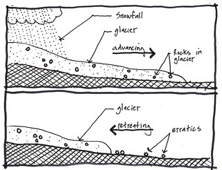
Early scientists believed these rocks were washed here in great floods. Today most scientists believe that erratics were transported to this area on great sheets of ice.As the glacier moves, it erodes large rocks and boulders and incorporates them into ice, allowing them to move with the glacier.
When the glacier retreated from the Chippewa Moraine area approximately 12,000 years ago, the ice melted and left rocks and boulders behind as glacial erratics.By identifying where the erratic originated, it’s possible to identify the source and direction of the glacier flow.For instance; in 1876, a man digging a well in glacial sand and gravel near Eagle, Wisconsin, found a 16.25 carat diamond whose source is believed to be from igneous rock called kimberlite from the Upper Peninsula of Michigan.
In the Chippewa Moraine the bedrock is mostly sandstone with some dolomite and shale. If an erratic is:
a) rhyolite, it probably came from Michipicoten Island, Canada to the northeast.
> Rhyolite is an extrusive igneous rock that is the volcanic equivalent of granite. In most rhyolite the crystallization began prior to extrusion. The color of rhyolite is variable, but light.
b) granite, it may have come from north-central Wisconsin to the northeast.
> Granite is a light-colored igneous rock with grains large enough to be visible with the unaided eye. It forms from the slow crystallization of magma below Earth’s surface. Granite is typically red, pink, gray or white color with dark mineral grains visible throughout the rock.
c) basalt, it could have come from the southwestern edge of Lake Superior to the north or northwest.
> Basalt, is an igneous (volcanic) rock that is low in silica content, dark in color, and comparatively rich in iron and magnesium.
 IATCC is the cache designation to highlight a series of EarthCaches along the Ice Age National Scenic Trail grouped into a special category called "ColdCache."
The Ice Age Trail is one of eleven National Scenic Trails designated by the National Park Service. This unique trail is entirely within the state of Wisconsin and follows along the terminal moraine of the most recent glacier which retreated about 10,000 years ago.
This project is supported by the Ice Age Trail Alliance (IATA). The goal is to bring more visitors to the trail and promote public awareness, appreciation, and understanding of Wisconsin’s glacial landscape.
The IATA has created an awards program to encourage visits to the trail and ColdCache sites. This awards program is separate from, and in addition to, any other Geo- or EarthCache awards program.
A current list of approved ColdCache sites can be found on the “IATCC Bookmark List”. More information on the Ice Age Trail Atlas, the Companion Guide, the ColdCache Project and Awards Program can be found on the “ColdCache Webpage”
DNR Permission
The Geocache Notification Form has been submitted to Brenda Rederer of the Wisconsin DNR. Geocaches placed on Wisconsin Department of Natural Resource managed lands require permission by means of a notification form. Please print out a paper copy of the notification form, fill in all required information, then submit it to the land manager. The DNR Notification form and land manager information can be obtained at: www.wi-geocaching.com/hiding
Resources
Geology of the Ice Age National Scenic Trail; by David M. Mickelson, Louis J. Mahler Jr., and Susan L. Simpson
Roadside Geology of Wisconsin; by Robert H. Dott, Jr and John W. Attig
To claim this find
1. Describe the erratic in terms of size, shape, color, and texture.
2. Based on the color and texture, where did the erratic most likely come from in terms of direction and distance? What does that tell you about to flow of the glacier?