Rottingdean's Rock Pools EarthCache
-
Difficulty:
-

-
Terrain:
-
Size:  (other)
Please note Use of geocaching.com services is subject to the terms and conditions
in our disclaimer.
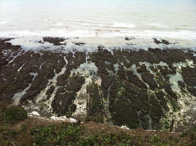
Rottingdean's Rock Pools (seen from the cliff top)
Welcome to Rottingdean.
Rottingdean is situated where a downland valley reaches the sea and there is a break in the cliffs, known as "The Gap". The village was once very isolated and inhabited mainly by fishermen, farmers and smugglers. Now it overflows with bungalows for the retired, homes of Brighton commuters and is known for its rock pools, which are considered some of the best in Southern England.
The high chalk cliffs offer excellent views in all directions. The chalk was formed 65 - 100 million years ago and the cliffs were created during the last ice age when the rising sea levels formed the English Channel.
The coastline is characterised by a narrow band of inter-tidal shoreline at the bottom of the steep chalk cliffs, with concrete walkways and steps to reach the beaches.
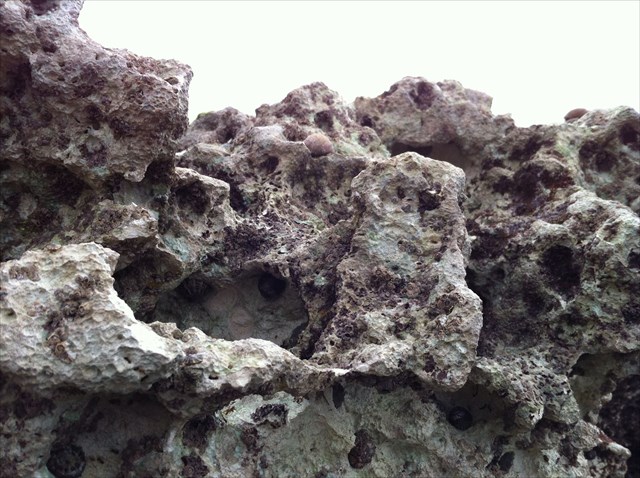
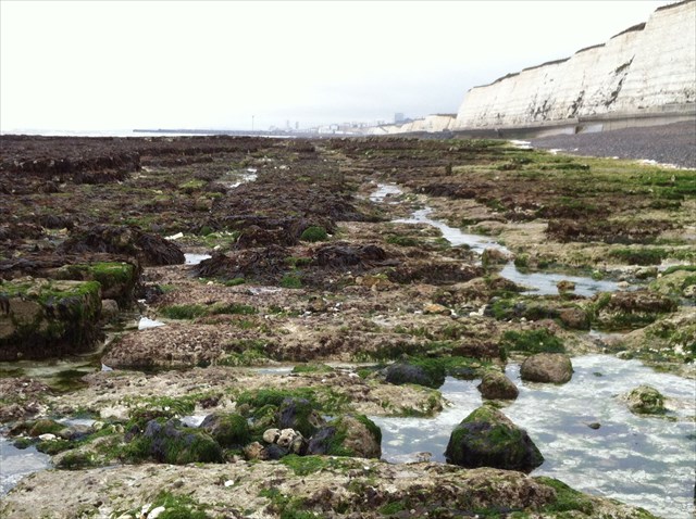
The cliffs run the length of this area, and the retreating cliff line, which has left a wave cut platform, has formed many beaches. On the platform lies chalk rubble and flint shingle. As chalk falls from the cliffs it is eroded by the sea, leaving the hard flint nodules. These accumulate on the shoreline and wave action erodes them into rounded pebbles to form shingle and sand beaches.

The platform continues to gently slope away from the base of the cliffs and has on first sight been eroded to a relatively level surface in places. However, when you look more closely you see that the surface is irregular, with rock pools, steps and runnels into which the ebb and flow of the tide is channelled. It is here that you can enjoy exploring the rock pools for yourselves, something I have done many times.
This is a constantly changing environment as a result of geomorphological processes, including longshore drift, which moves the shingle along the beach from west to east. Where the chalk cliff has been or is now under threat from erosion by the sea, a number of sea defences have been introduced to control and prevent further retreat of the cliff.
This area forms part of the Brighton to Newhaven Site of Special Scientific Interest (SSSI), largely due to its exposure of important chronological fossils.
Another unique feature associated with the rock pools is the remains of the Brighton and Rottingdean Seashore Electric Railway, better known as the Daddy Long Legs. Magnus Volk, its owner, designer and engineer created a unique coastline railway, which ran through the shallow coastal waters between Brighton and Rottingdean from 1896 to 1901. The remains of the sleepers, wooden poles and metal fixings can still be clearly seen, but the same process that formed the rock pools is claiming them and they have become part of the rock pool formation.
Further information on the Brighton and Rottingdean Seashore Electric Railway can be found at The Daddy Long Legs and Coast.
The Route of the Railway Track
In conclusion, this is a fantastic, exposed, wild landscape ,which is open to the elements with a character governed by the weather, so enjoy!
Important Information
The co-ordinates for this cache will bring you to a set of concrete steps that lead down on to the beach.
To get the most from your visit it is best to arrive at low tide, therefore you may want to check the Tide Times.
To claim this EarthCache as a find please send your answers to me by either using the message centre, or email. All emails should show your caching name (eg terrapintim) and email address and they should be sent to my email through my profile. Your answers should be sent to me BEFORE YOU LOG YOUR FIND, and afterwards you can then log the cache as a find and upload your photo (if you choose to do so). Please DO NOT reveal any of the answers in your log! Finally, you DO NOT have to wait for my reply, as I will contact you if there are any problems with your answers. I will however do my best to respond out of courtesy as soon as possible 
Tasks
1. In which geological period were the cliffs originally formed?
2. Walk down the beach towards the rock pools and observe the structure of the beach. Explain how you can see that the Longshore Drift is from West to East.
3. Continue down the beach and on to the rocks. Inspect them closely and describe the erosional/weathering processes that you can see.
4. The rock pools mainly consist of two types of rock, what are they called?
5. The tide ebbs and flows through channels in the rocks, what are the channels called? Describe the channels structure and how they interact with the rock pools.
Optional Task
6. As an optional extra find the wooden pole at N 50° 48.167 W 000° 03.684, take a photo of you/your GPSr with the pole in the background and post it with your log, but take care, the rocks can be slippery!
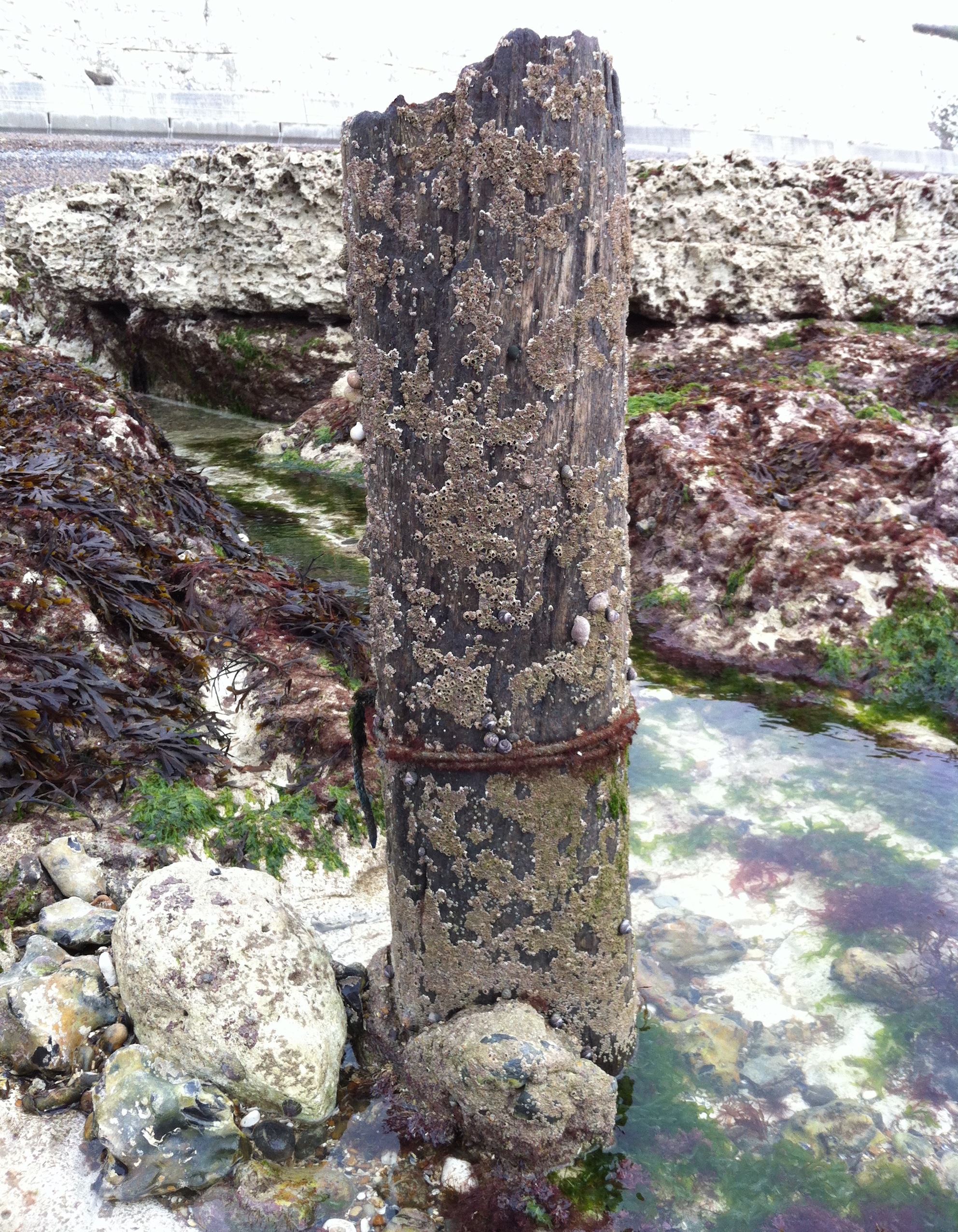
Wooden Pole
Additional Hints
(No hints available.)