Bay of Haifa / Bay of Acre
The Bay of Haifa or Haifa Bay, formerly Gulf of Acre or Bay of Acre, is a bay along the Mediterranean coast of Northern Israel. Haifa Bay is Israel's only natural harbor on the Mediterranean.
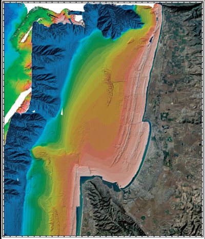
A natural harbor is a landform where a part of a body of water is protected and deep enough to furnish anchorage. Many such harbors are rias.
A ria is a coastal inlet formed by the partial submergence of an unglaciated river valley. It is a drowned river valley that remains open to the sea. Typically, rias have a dendritic, treelike outline although they can be straight and without significant branches. This pattern is inherited from the dendritic drainage pattern of the flooded river valley. The drowning of river valleys along a stretch of coast and formation of rias results in an extremely irregular and indented coastline. Often, there are islands, which are summits of partly submerged, pre-existing hill peaks.
Natural harbors have long been of great strategic naval and economic importance, and many great cities of the world are located on them. Having a protected harbor reduces or eliminates the need for breakwaters as it will result in calmer waves inside the harbor.
The bay of Haifa is the only major interruption of the coastline of Israel, which otherwise runs very evenly. It is formed by the fact that on the south end the Mount Carmel in the Cap of Carmel points to the north-west. In the north, the bay is protected by a small peninsula on which the city of Akko (Acre) is situated. In the north-south direction, the bay, which is open to the west, measures about 12 kilometers, the most important inflow being the Kishon River.
Fed by the Kishon River, the cities of Haifa and Acre (Akko or Akkon) mark its southern and northern capes, while its centre is lined with dunes and the suburban Krayot neighborhoods. Mount Carmel rises from the southern edge, while the mountains of the Western Galilee run up to the shore at the northern boundary. The Port of Haifa lies along part of its southeastern coastline.
Haifa Bay also signifies one of Haifa's nine boroughs, covering the overwhelmingly industrial area northeast of Downtown and south of Kiryat Hayim.

Log conditions:
At the listing coordinates you have an overview to the Bay and you can see Haifa in the distance. Answer the following question:
1. As we have already explained, this bay is a Ria. How do you recognize this? Observe the surroundings of the bay and the water depth. What are the indications that this is a Ria. Why is this type of bay so valuable to the region?
2. What is the wave formation here in the bay? Give your answer based on the description above.
3. Take a picture of the area with your GPS and the bay in the background (or the nice animal from stone) and insert it within your log.
Send the answers of the questions to Fam.Weiss with your GC-name in the subject-line. We contact you if something is wrong.
Attention – Please note!
Please don´'t write the answers into your internet-log at GC!
Log entries without answering the questions will be deleted by us directly without any further enquiry!
Attention: To fulfill the log condition you have to send a reply mail with the answers for the questions per Geocaching account! A "multiple answer mail" for several Geocaching accounts therefore only fulfills the log condition for the respective sender! The logs of the other accounts are deleted without comment!