[ skip down for English ]
Nederlands
Tijdens een wandeling van ongeveer 1,5 km (2 km om weer terug op het startpunt uit te komen), verzamel je 6 cijfers (A t/m F). De cache ligt op N 51° 55.ACB E 004° 26.DFE - let op de volgorde!
Per waypoint vind je één cijfer. Naast de omschrijving hieronder is er voor elk waypoint ook een foto beschikbaar waarop het cijfer dat je moet vinden, vervangen is door de letter. Je zou genoeg moeten hebben aan de omschrijving, maar als je twijfelt kan je de foto als hint gebruiken. Je mag natuurlijk ook het tegenovergestelde doen: volg de foto's en gebruik de tekst als achtervang; die versie is vooral leuk als je met kinderen op pad gaat! Voor deze variant is ook een print-vriendelijke pfd beschikbaar.
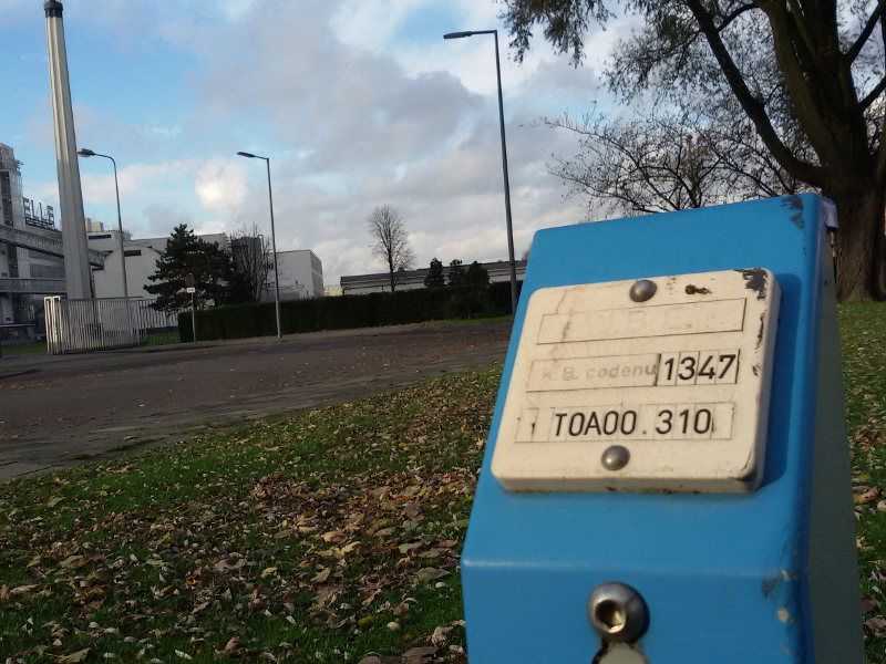
Waypoint 1 - N 51° 55.363 E 004° 26.121 - De wandeling begint bij de Van Nellefabriek. Op waypoint A vind je een paaltje met K.B. codenu[mmer]. A is het derde teken van de tweede regel: T0A00.310
(Premium members: Voordat je verder loopt naar WP2, kan je even geocache GC378M6 ophalen.)
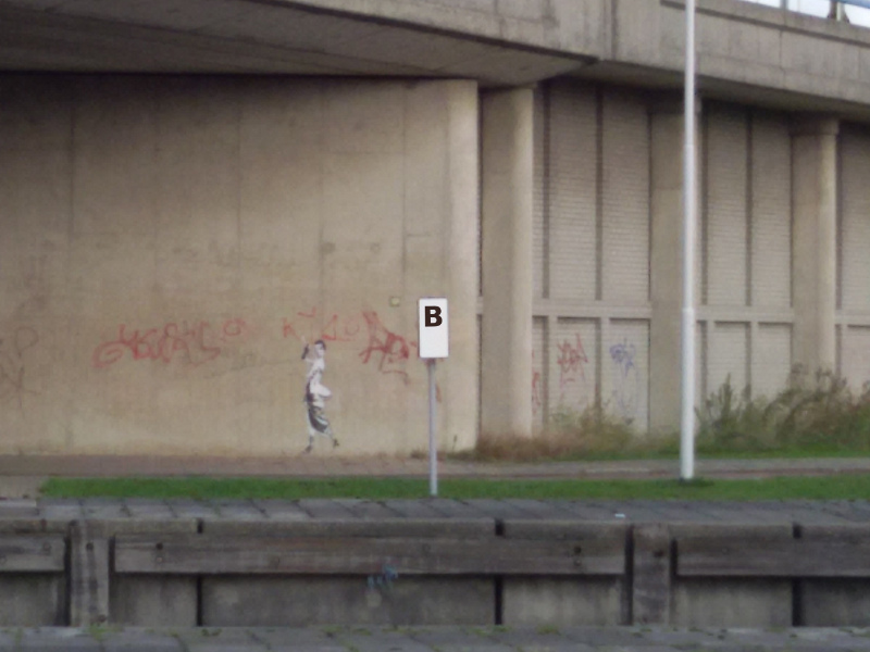
Waypoint 2 – N 51° 55.312 E 004° 26.221 - Je staat nu tussen twee bruggen: een spoorbrug en een brug voor wegverkeer. Aan de overkant van het water staat een wit bord met een zwarte rand en een zwart cijfer. Dit cijfer is B.
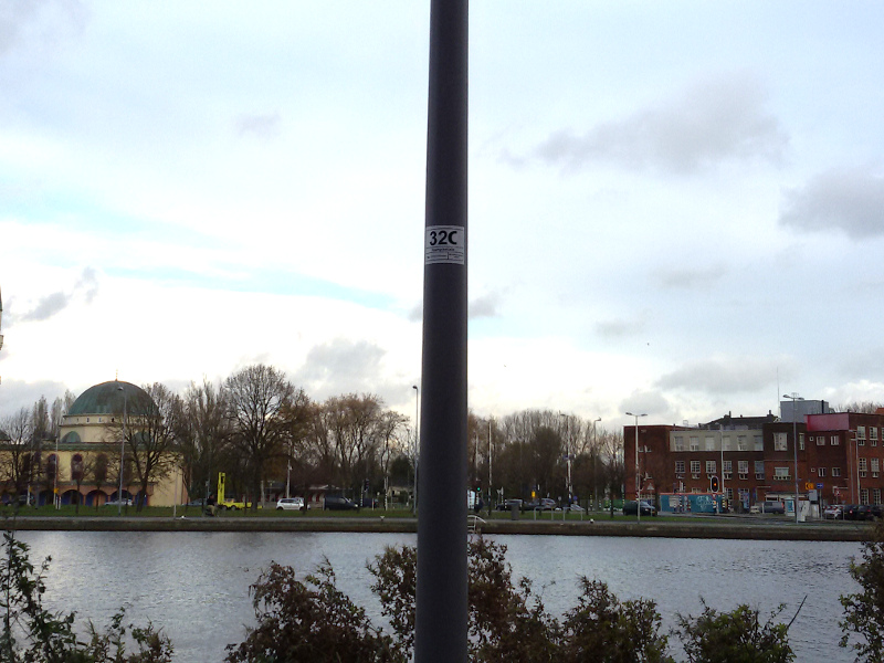
Waypoint 3 – N 51° 55.163 E 004° 26.414 - De lantarenpaal (de eerste links) heeft een drie-cijferig nummer. Het derde cijfer is C.
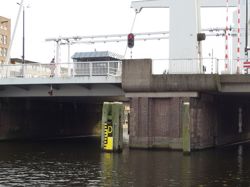
Waypoint 4 – N 51° 55.015 E 004° 26.596 - Je bent nu bijna bij de Mathenesserbrug. Onder de brug (in het water) staat een zwart/geel bord met waterhoogtes. Het bovenste cijfer (geel cijfer op zwarte achtergrond) is D.
We steken nu de brug over. Je kan via de trappen naar boven en naar beneden, maar als je een kinderwagen, rolstoel, fiets of iets dergelijks mee hebt zijn er ook drempelvrije routes. De brug op kan via het paadje langs de hortensia's (via N 51° 55.006 E 4° 26.579 of Waypoint X). Om aan de overkant de brug af te komen moet je een omweg maken via N 51° 55.065 E 4° 26.711 en N 51° 55.131 E 4° 26.633 (Waypoint Y1 en Y2): vanaf de brug rechtdoor, eerste straat links (Allard Piersonstraat) en meteen weer links (Craandijkstraat). Je komt dat precies tegenover waypoint 5 uit.
NB: als je aan de overkant van de brug de trap naar beneden neemt, kan je daar meteen de straat oversteken om weer aan de kade te komen, maar dit is, vooral in de spits, een heel drukke weg. Veiliger is het om het eerste stuk langs de huizen te lopen. Bij waypoint 5 is er zebrapad naar de kade.
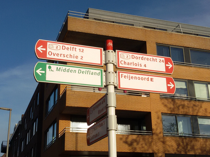
Waypoint 5 – N 51° 55.109 E 004° 26.595 - Het aantal km naar Feijenoord is E.
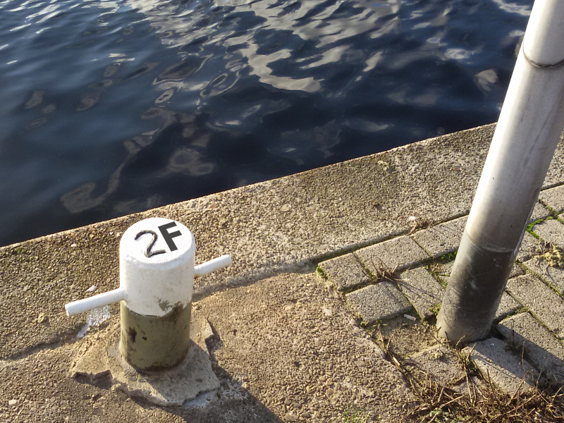
Waypoint 6 – N 51° 55.207 E 004° 26.455 - Deze aanlegpaal (vlak naast lantarenpaal 17) heeft een twee-cijferig nummer. Het tweede cijfer is F.
De cache ligt op N 51° 55.ACB E 004° 26.DFE (let op de volgorde!). Als het goed is krijg je een coordinaat dat in het verlengde van de route ligt. Voor de eindlocatie moet je ongeveer twee meter van het pad af; je ontkomt niet aan beetje klauteren maar natte voeten riskeren is niet nodig. Je kan via de Beukelsbrug (N 51° 55.289 E 4° 26.298) weer terug naar het beginpunt.
Succes!
English
During this 1.5 km walk (2 km to get back where you started), you will collect 6 numbers (A to F). The cache is hidden at N 51° 55.ACB E 004° 26.DFE - note the order!
At each waypoint, you'll find one number. Besides the text below, there is also a photo for each waypoint with the number replaced by the corresponding letter. You can either follow the text (each description should give you enough information to find the numbers) and use the photos when you're unsure, or you can follow the photos and use the descriptions as a backup. The latter option is especially child-friendly, and convenient pdf handout is available.
Waypoint 1 - N 51° 55.363 E 004° 26.121 - The walk starts at the Van Nellefabriek, formerly a tobacco factory, now a 'design factory' where creative companies can rent space. Here you'll find marker with a K.B. codenu[mber]. The third character of the second line is A: T0A00.310.
(Premium members: Before you walk on to WP2, you can pick up geocache GC378M6.)
Waypoint 2 – N 51° 55.312 E 004° 26.221 - You're in between two bridges: a rail bridge and a road bridge. Across the water you'll see a black-rimmed white sign with a black number on it. This number is B.
Waypoint 3 – N 51° 55.163 E 004° 26.414 - The lamp post (first on your left) bears a three digit number. The third digit is C.
Waypoint 4 – N 51° 55.015 E 004° 26.596 - We've almost reached the next bridge: the Mathenesserbrug. Below the bridge (in the water) there's a black and yellow water level marker. The upper digit (yellow number on a black background) is D.
We'll now cross the bridge. You can use the stairs to get up to bridge level and down again on the other side, but if you have a stroller, wheelchair, bike or similar with you, there are alternative routes. You can get up the bridge via the path with the path along the hydrangeas (N 51° 55.006 E 4° 26.579 or waypoint X). To get down on the other side of the bridge, you'll have to make a little detour via N 51° 55.065 E 4° 26.711 and N 51° 55.131 E 4° 26.633 (waypoints Y1 and Y2): after the bridge you go straight ahead, take the first left (Allard Piersonstraat) and left again (Craandijkstraat). You'll end up exactly opposite waypoint 5.
NB: if you take the stairs down at the other side of the bridge, you need to cross a very busy street to get back to the quayside. Keep to the side of the street with the houses at first, and use the zebra crossing at waypoint 5 to cross the street safely.
Waypoint 5 – N 51° 55.109 E 004° 26.595 - Distance to Feijenoord is E.
Waypoint 6 – N 51° 55.207 E 004° 26.455 - This mooring bollard (the one right next to lamppost 17) has a two-digit number. The second digit is F.
The cache is at N 51° 55.ACB E 004° 26.DFE (NB: note the order!). If you get a final coordinate which is not a continuation of the route so far, you've made a mistake somewhere. The cache is about two meters from the path; you'll need to do some clambering to get it but there's no need to risk getting your feet wet. You can get back to the starting point via the Beukelsbrug (N 51° 55.289 E 4° 26.298). Good luck!
Foto's | Photos
De cache ligt op N 51° 55.ACB E 004° 26.DFE - let op de volgorde! | The cache is hidden at N 51° 55.ACB E 004° 26.DFE - note the order!
Foto's zijn ook beschikbaar als print-vriendelijke pfd | Photos are also available as printer friendly pdf.
Waypoint 1:
Waypoint 2:
Waypoint 3:
Waypoint 4:
Waypoint 5:
Waypoint 6:
 FTF: mp3crew
 STF: Amerod, Dooremco, georobbin & Sonnetjes
 TTF: GIO53
Allemaal van harte gefeliciteerd, merci voor jullie mooie woorden, en GIO53 + Amerod veel dank voor jullie favourite points - daar doe ik het voor!