Gerník (Garnic)
(rum. Gârnic, nem. Weitzenried, mad. Szörénybúzás)
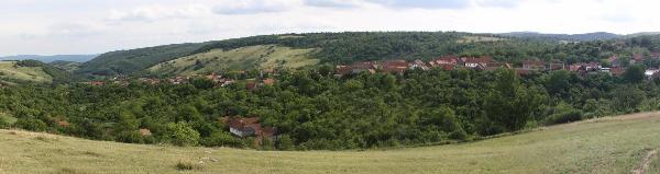
Vesnice zacala vznikat již v roce 1827 na dvou návrších, mezi nimiž protéká malý potucek, který prirozene rozdeluje vesnici na tzv. „malou“ a „velkou“ stranu. Nemecký, madarský i rumunský název vesnice je odvozen od latinského Valeus Granica, tj. pšenicné údolí. Vesnice leží ve výšce od 450 do 550 m n. m. na krasovém podloží. V roce 1830 mela 469 obyvatel, v roce 1934 pak 1400 obyvatel, v roce 1991 zde žilo 910 obyvatel a v roce 2002 již jen 512 obyvatel, v 2. polovine r. 2008 necelých 350 obyvatel. Cca 20 zdejších stavení je už v majetku rumunských chalupáru, prevážne z Temešváru. Od Dunaje (pres Sikevici) je Gerník vzdálen 12 km, od Nové Moldavy (pres Padinu Matei) cca 20 km.
Gernický kostel (1858) je zasvecen sv. Janovi Nepomuckému a cenný relikviár s kustkou mu venoval pražský arcibiskup Bedrich kardinál Schwarzenberg. Jako jediná z ceských vesnic má Gerník svuj obecní úrad, pod který spadají i okolní salaše a rumunská osada Padina Matei. Vetšina zdejších stavení je napojena na obecní vodovod. Jsou zde dve denne otevrené hospody spojené s obdchodem, tretí (príležitostnou) byste našli nad pekárnou vlevo obchodu. V obci se nachází dva soukromé „kazany“ (palírny koralky), poštovní a farní úrad, velká kaplicka sv. Jana Nepomuckého a 14 malých kaplicek krížové cesty. Gerník má rovnež svou vlastní kapelu, která slaví úspechy doma i za hranicemi vesnice.
Gernicané donedávna pálili podomácku stavební vápno v malých polních vápenkách severne a severozápadne od vsi. Vápno pak prodávali prímo z vozu v širokém okolí své vesnice. Díky vápenci je okolí vesnice mimorádne malebné, bohaté na závrty a skalní útvary, v samotné vesnici se nachází jeskyne Filipova díra. Gernictí již tradicne melou mouku na vodních mlýncích (vodenicích), které jsou jak v obci, tak i za vesnicí v nádherné typicky krasové lokalite U Petra.
Výlety v okolí vesnice
- K monumentální jeskyni „Turecká díra“ (po cervené znacce smerem na Svatou Helenu, pak odbocka po modré, asi 1,5 hodiny).
- Do ceské vesnice Rovensko (krásné výhledy, po cervené turistické znacce asi 3,5 hodiny, možnost ubytování a stravování).
- Do ceské vesnice Svatá Helena (po cervené turistické znacce asi 3,5 hodiny, výhledy na Dunaj, možnost ubytování a stravování).
- K unikátním vodním mlýnkum v lokalite „U Petra“ (po cervené turistické znacce asi 1 hodinu, krasová rícka, možnost koupání v tuních, možnost táborení).
- Do Sopotu Nou po nove vyznacené znacce (asi 16 km) a odtud do kanonu reky Nera.
- Do Carbunari po nove vyznacené znacce (asi 15 km) a odtud do kanonu reky Nera (pres Sasca Romana).
Filipova díra
Jeskyne v Gerníku u pramene, který je zdrojem pro obecní vodovod. Podle povesti bydlel v jeskyni muž se ženou, Filip a Filipka. Filip mel jít do války, a proto se v jeskyni schovával. Opravoval deštníky, hrával na housle po Gerníku a jeho žena tancovala spolecne s cviceným medvedem. Kamenný stul, u kterého jedli, je prý dodnes schován na samém konci jeskyne.
Zdroj: Pruvodce Banát vydaný cestovní kancelárí Kudrna, 3. vydání, 2009.
[EN]
Garnic
The village began to exist in 1827 on two hills with a small water flow inbetween, which naturally divides the settlement into so-called "Mala strana" and "Velka strana" (Little and Great Part). All the names of the village - German, Hungarian and also Romanian - are derived from Latin name "Valeus Granica”, which means "Wheat Valley". The village is located in height ranging from 450 - 550 meters above the sea level on karst soil. In 1830 lived there 469 citizens, then 1400 in 1934 , in 1991 lived there 910 people; in 2002 just 512, in second half of 2008 only 350 people. Approximately 20 houses there belong to Romanian cottagers, mainly from Timisoara. Garnic is 12 km far from Danube (via Sikevica) and 20 km from Nova Moldava via Padina Matei.
Church in Garnic (185) is consecrated to Saint Jan Nepomucky and worthy reliquary with a bone was a gift from Archbishop of Prague, Cardinal Schwarzenberg. Uniquely, Garnic has his own municipal house, which administrates the neighboring sheepfolds as well and Romanian village Padina Matei. Most of the dwellings have tap water. There are two pubs opened daily and they contain a small groceries shop as well, you could find the third shop above the bakery on the left side. The village has two private "kazan" (houses where alcohol is being produced), post office, parish’s house, chapel of Saint Jan Nepomucky and 14 small chapels of the Via Dolorosa. Garnic has his own music band which is famous here as well as in other villages.
Until recent, the villagers made lime casually building in small field limekilns located in north and northwest from the village. They used to sell lime directly from carriages in villages even far from their own. The vicinity of the village is picturesque, rich on karst falls and rock formations, thanks to the limestone. You can find a cave directly in the village which is called Filipova díra (Filip’s hole). The people of Garnic traditionally grind flour on water mills (vodenica), which are build in the village, as well as behind it in beautiful, typically karst location "U Petra".
Filipova díra (Filip’s hole)
The cave is located in Garnic near the spring, which is the source of tap water for the village. According to a legend, a couple, Filip and Filipka, lived there. Filip had to go to war, so he hid himself in the cave. He repaired umbrellas, played the violin throughout the Garnic and his wife danced with a tamed bear. A stone table, which is said to be their dining table, should be hidden in the very end of the cave.
[RO]
Garnic
Despre Comuna
In anul 1827, in urma unei hotarari a conducerii Imperiului Austro-Ungar privind popularea granitelor Imperiului, 56 de familii de cehi din Bohemia au ajuns plutind pe Dunare in partea de sud a Banatului romanesc, stabilindu-se in actualele sate: Garnic, Sfanta Elena, Ravensca, Eibental, Bigar, Sumita. Acesti colonisti cehi au reusit sa isi pastreze foarte bine, in decursul timpului, limba, cultura si obiceiurile din tara lor de bastina. In sate se vorbeste si acum limba ceha, gospodinele te imbie cu coloaci traditionali cehi iar seara batranii povestesc istorioare din trecut. Comuna Garnic, formata din satul Garnic si satul Padina Matei, este situata in partea sudica a judetului Caras-Severin, in Clisura Dunarii, la o altitudine de 705 m fata de nivelul marii si la o distanta de 150 km de orasul Resita. Garnicul se invecineaza cu comuna Sichevita (7 km), cu comuna Carbunari (18 km), cu satul Ravensca (15 km), cu satul Sfanta Elena (14 km) si cu satul Moldovita (7 km). Relieful este predominant deluros, cu vegetatia bogata, compusa in mare parte din paduri de fag, iar datorita faptului ca in aceasta zona s-a practicat o agricultura nepoluanta se pot intalni aici multe specii de animale salbatice. Populatia comunei este compusa in mare parte din cehi. Acestia se ocupa in general cu agricultura, crestera animalelor si agroturismul, si doar o parte lucreaza in industrie. De asemenea, datorita faptului ca zona este bogata in piatra de calcar, localnicii se ocupa si cu fabricarea varului, care se arde in cuptoare sapate in pamant si este distribuit apoi in toata zona Clisurii. Aceasta meserie se practica inca de la venirea primilor colonisti cehi in comuna.
Obiective Turistice
Panoramele foarte intinse deasupra Dunarii ii invita pe turisti sa strabata aceste locuri pe jos sau pe bicicleta, traseele turistice fiind marcate intre toate cele sase sate, trasee ce trec prin canioane frumoase, pe langa cursuri de ape cu mici cascade, chei si mori de apa. Teritoriul comunei prezinta un potential turistic bogat, fiind inclus in Rezervatia mixta Valea Mare care are o suprafata de 1179 ha, face parte din Parcul National Portile de Fier si este protejata cu indicativul 2298PN-Dsi. In aceste zone se poate petrece timpul liber intr-un mod foarte placut, putandu-se vizita pestera din Padina Matei, grota haiducilor si cascada de pe raul Modavita (Valea Mare). De asemenea, se poate vizita cascada si complexul de mori de apa de pe raul Gramensca, in apropierea satului Garnic.
http://www.garnic.go.ro/
Cache
Umístení/Placement
Cache je uložena v blízkosti vchodu do jeskyne Filipova díra.
Cache is hidden near the entrance to the cave Filipova díra.
Velikost cache/Cache size
Regular.
Historie cache/Cache history
21. 5. 2009 - založení fyzické cache / physical foundation of the cache
19. 7. 2009 - první verze listingu / first version of listing