[FR]
Le Pont d'Oxford est un pont à haubans au dessus de l'Isère,
dédié à la circulation, situé dans le nord de Grenoble. Achevé en
1991, il permet de relier le quartier du Polygone scientifique à
l'Autoroute française A48. Il est nommé ainsi en l'honneur du
jumelage de Grenoble avec Oxford depuis 1988.
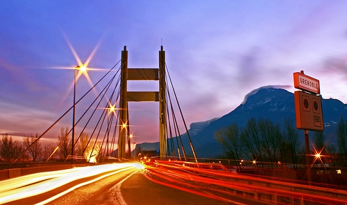
Le pont d'Oxford en arrivant par le
Nord
La cache se trouve dans un rayon de 200m autour de la coordonnée
indiquée. Pour trouver la coordonnée finale, il vous faudra d'abord
connaître :
- A = Somme des chiffres de l'année du baptême du pont. Il
y a une plaque commémorative sur le pont.
- B = Le nombre de câbles qui arrivent au sud du poteau
qui dispose d'un paratonnerre.
- C = Le nombre de câbles qui arrivent au nord du poteau
qui dispose d'un paratonnerre.
- D = Le nombre de lettres de la société la plus proche du
pont.
Les coordonnées finale sont : N 45° 12.XXX E 5° 42.YYY avec
- XXX = 3 * ( D! + C)
- YYY = D! + A + B + 2

Note:
- Malheureusement pas trop de parking à proximité, par contre
il est très facile d'y arriver par la piste cyclable en vélo ou à
pied.
- Attention aux moldus travailleurs qui pourraient vous
observer au travers des fenêtres...
[EN]
The Oxford bridge is a cable-stayed bridge over the Isere,
dedicated to traffic, located in the north of Grenoble. Completed
in 1991, he used to connect the area of the Polygon scientist at
the A48 motorway. It is named in honor of the twinning with Oxford
and Grenoble since 1988.
The final cache is in the 200 meters neighborhood from the
initial location. For the final location, you have to find some
informations :
- A = Sum of numbers of the baptheme year of the bridge.
There is a commemorative plate on the bridge.
- B = Number of cables fixed on the south of the pole that
have a lightning rod.
- C = Number of cables fixed on the north of the pole that
have a lightning rod.
- D = Number of letters of the company the closest from
the bridge.
Final coordinate are : N 45° 12.XXX E 5° 42.YYY with
- XXX = 3 * ( D! + C)
- YYY = D! + A + B + 2
Note:
- Sadly, not a lot of cars park in the surrounding, prefer the
bike path, by bike or foot.
- Be careful to moldus workers that could watch you trought
the windows...