Visiting any Earth Cache is more than just "Logging A Find". It is
an "Earth Science Lesson", and I hope you will enjoy mine.
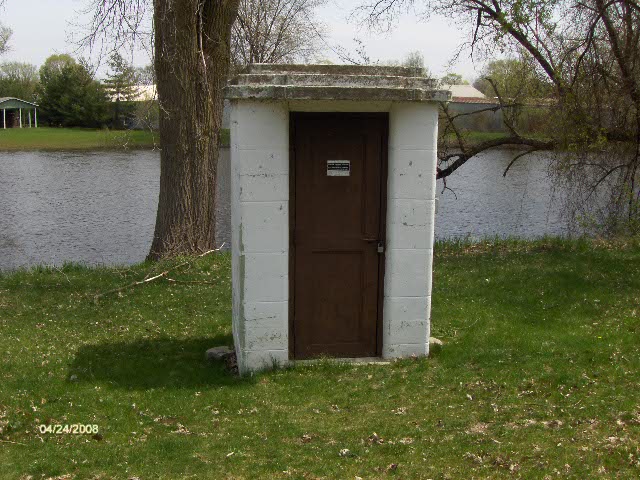
A gaging station is a facility used by hydrologists and others
to monitor streams, rivers, lakes, canals, reservoirs, and other
bodies of water. Gaging stations typically collect information such
as water height and discharge (flow). The rivers height in today's
world can be critical to adjacent properties, both residential and
rural farming lands. Primary considerations to be considered are
excessive snowfall and rainfall, drought conditions and possible
water diversions. The collected information is recorded by a site
visit or is transmitted via telephone or a satellite communication
system to the stations owner. St. Joseph River Gaging Station at
Three Rivers, Michigan The St. Joseph River (locally known as the
St. Joe) is a river, approximately 210 mi (338 km) long, in
southern Michigan and northern Indiana in the United States. It
drains a primarily rural farming area in the watershed of Lake
Michigan. It was enormously important in the days of Native
Americans and the colonial settlement as a canoe route between Lake
Michigan and the watershed of the Mississippi River. It is
sometimes known as St. Joseph River of Lake Michigan to distinguish
it from the nearby St. Joe River in the Maumee River watershed. The
Three Rivers Gaging Station is operated by the USGS (United States
Geological Survey). Recording started in 1953. This gaging station
records water height and discharge and transmits its data back to
the USGS headquarters. Very close to this location, two other
rivers meet the Saint Joseph River, the Portage and Rocky Rivers.
The posted coordinates above will lead you to the staff gauge.
Gauging Station History In the 1880's, John Wesley Powell, the
second director of the USGS, requested that stream flow be
monitored in eight river basins in the West. It was his idea to
measure the flow of streams and rivers and determine the viability
of irrigation systems for this acrid region. In 1889, the first
U.S. stream gaging station was established on the Rio Grande River
in New Mexico. At this station, standard stream flow measurement
procedures were devised. Today, the USGS operates and maintains
more than 85% of the nation's stream gaging stations. There are
over 7,000 stream gaging stations in the United States, Puerto
Rico, and the U.S. Territories of the Pacific Islands. The USGS
uses it's stream gaging network to provide a free continuous source
of well documented and archived water data. This data is used by
government agencies and private companies to forecast flooding,
design bridges, allocate drinking and irrigation water, for
recreational use, and to manage our valuable surface water
resources.
BEFORE you log
this cache:
1) Post a picture of yourself/team with gps with the gauge house
in the background.
2) Record the height of the river on the appropriate staff gage
and post your reading on the cache page.
Failure to meet these simple requirements will delete your log
without notice.
As of March 24 2009,
pre-posting a find on this cache will be deleted without notice.
Please post your find when you get your logs/pictures in order and
not before.