HR
Uvala Voz se nalazi na sjeveroistočnom dijelu otoka Krka, u uvali dobro zaštićenoj od bure i juga. Povoljan zemljopisni položaj, kao i neposredna blizina rta Lanterna (Vošćica) na kojem se Krk najviše približava kopnu, a Tihi kanal ima širinu od svega 500 metara, učinili su je povijesnom.
U antičko doba tu je bila smještena mala, ali sigurna trgovačka lučica, možda i carinska postaja, a provedena arheološka istraživanja dokazuju i postojanje vojnog logora. Govore nam o tome pronađeni predmeti; grobovi s ranorimskim prilozima, ostaci utvrde, željezni vrh koplja, dio rimskog puta koji je vodio od Voza prema rtu Lanterna i drugo. Prateći tragove povijesti, sve smo sigurniji da se upravo tu 49. godine prije Krista odigrala čuvena bitka izmedu Cezara i Pompeja.
Cezarova je vojska u bici bila poražena te su sklonište našli na poluotoku Bejavec. Bijeg s Krka na kopno ostvarili su izradivši splavi od bačvi koje su im napravili Liburni na Krku. Jedna izgubljena bitka ne znači i izgubljen rat, te je Cezar potpuno porazio Pompejevu vojsku kraj Šćedra blizu Hvara 47.p.n.e.
Opis njihovog povrata na kopno na splavima koje su učinili povezujući bačve ujedno je i najstariji zapis koji spominje bačve (bilo je uobičajeno tada čuvati vino i ostalo u amforama).
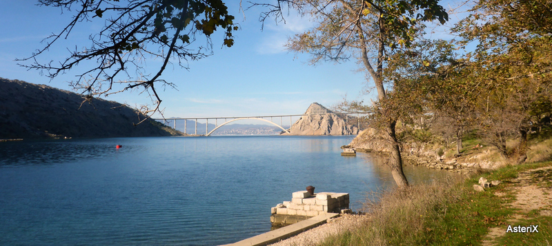
Prije no što je sagrađen Krčki most uvalu Črišnjevo i otok Krk (uvalu Voz) spajao je trajekt.
fotografija preuzeta sa foruma Željeznice.net

Ostaci pristaništa su još uvijek dobro vidljivi. U uvali Voz mnogi se vole i danas okupati i uživati u jednom od najboljih pogleda na Krčki most.
EN
Bay Voz is located in the NE part of island Krk , in a bay well protected from the north and south winds. The convenient geographical position, and proximity of the cape Lanterna (Vošćica) where Krk is closest to the land and the Tihi Channel with a width of only 500 meters, made this place historical.
In ancient times there was a small but safe commercial harbor, perhaps even a customs point. Conducted archaeological research has proved the existence of a military camp. Some of the found objects were Early Roman graves, remains of a fortress, iron spearhead, part of a Roman road that led from Voz to Cape Lanterna and more. Following the traces of history, we are all confident that here in year 49 BC took place a famous battle between Caesar and Pompey.
Caesar's army at the Battle was defeated, and they found shelter on the peninsula Bejavec. Escape from Krk ashore was achieved by making a raft of barrels constructed by the Liburnians on the island. As one lost battle does not mean a lost war, Caesar defeated Pompey's army at island Šćedro near Hvar in year 47.pne
Description of their return to the mainland on rafts that have been done by connecting the barrels is also the oldest record mentioning a barrel (it was common then to keep the wine and other goods in amphorae).
Before Krk bridge was built, a ferry was connecting the mainland (Črišnjevo bay) and the island of Krk (bay Voz). The remainings of the ferry port are still visible. Many people love to come here for a bath and enjoy one of the best views to Krk bridge.