
Short:
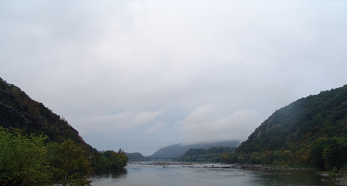
Approximately 360 million years ago, when the continent of Africa
collided with North America, land comprising the park began to take
its current shape. At this time the Appalachian Mountains rose and
the Potomac River began cutting through them, forming the water gap
we see today between Maryland and LoudounHeights. Today this gap
marks the confluence of the Potomac and Shenandoah Rivers and is
considered by many to be the area's most prominent geological
feature.
Long:
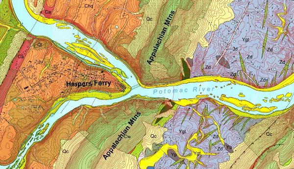
Located in the Blue Ridge Mountain section of the extensive
Appalachian Mountain Range that extends from Quebec south to
Alabama. The mountains we see today rose X million years ago when
the continent of Africa collided with the continent of North
America. This collision caused the Appalachian Mountains to rise
taller than the Rocky Mountains are today. At that time the Potomac
began cutting its way through the Appalachian Mountains, forming
the water gap that lies between Maryland and Loudoun Heights. After
the Appalachians were worn down, run-off water collected at their
base, forming the Shenandoah River. Worn down by rock, wind, rain,
and ice, only the roots of these once great mountains remain. The
beauty of these rolling mountains and the Shenandoah and Potomac
rivers coming together is a sight everyone should see!
According to the United States Geological Survey, Harpers Ferry
may experience a flood over 20 feet every 5 to 10 years . The 1936
flood, which reached a record height of 36.5 feet, is estimated to
only occur every 125 years. Floods in the park tend to be fairly
deep, since there is not much room for water to spread out once it
overflows its banks here. During the early months of the year,
heavy precipitation that produces rapid runoff is a major
flood-causing factor.
 ***Do not log this cache until you
already sent in the answers, your log will be deleted without
question.***
***Do not log this cache until you
already sent in the answers, your log will be deleted without
question.***
Requirements:(if you send less than what
is required the log will get deleted)
1. In a sentence or two, how long do you think it took for the
river to cut thru?
2. Looking at the Shenandoah River, what is direction is the fault
line?
3. And how does it relate to the mountain range?
4. Post a photo of you and your GPS with the Gap in the
background
"The passage of the Patowmac through the Blue Ridge is perhaps
one of the most stupendous scenes in Nature."
- Thomas Jefferson, 1783
***This Earthcache is 100% Handicap
accessible!***
