This pond/lake itself is on private property, so please don't go past the fence, just look at it from the road. Watch for wildlife, especially birds. Pelicans, herons, geese and ducks are often spotted here! You can see this oxbow formation from many points along this road. Feel free to drive along it so you can better see the whole thing. It may help in answering the questions!
The Bear River meanders for approximately 491 miles through Utah, Idaho and Wyoming. It starts in the Uintah mountains of eastern Utah, goes northward throught Wyoming, back into Utah, then up to Idaho. Finally, it makes a U-turn, and heads south, ending up in the Great Salt Lake. It is the largest tributary of the Great Salt Lake, and is the largest river in North America that does not ever reach an ocean.
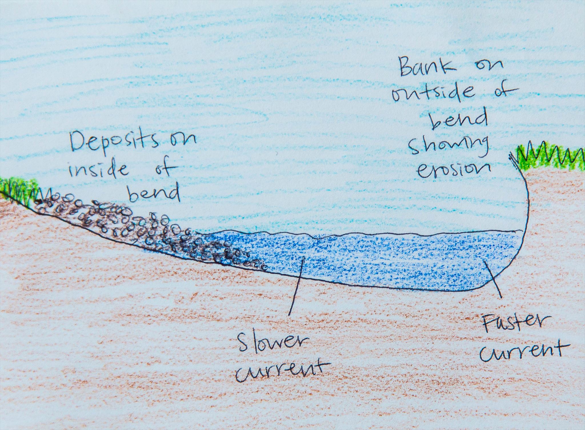
The Bear River has many twists and turns in it. Some of these twists and turns have turned into oxbow lakes (or ponds). In a river, the outside of a curve produces more force and cuts away at the banks (erosion). In contrast, the inside turns are slower, and the sediments from the faster side usually end up over on the slow side (deposition). When there is a large U shaped curve in a river, the open ends of the U are both cutting into each other. Eventually, the land will disappear, and the river will have created a "shortcut".

As the river forges its new path, sediments are built up, and a new "wall" is created, effectively cutting off the old part of the river. The river shape is still there, and in most cases, water will stay in the formation, creating a U shaped lake or pond. (This one is more like a pond than a lake. ) An oxbow lake can take just a few years to develop, or even hundreds of years!

If we took a cut away of the river, this is what it would look like. The outer curve of the river will cut a wall or cliff, while the inside curve builds up sediments. This is also a great thing to know if you're swimming or fishing in a river!
Logging requirements:
-
Determine where the river is now, where it used to run, and where the lake is now. Use the satellite map on your phone/GPS if necessary. How much of the oxbow lake do you think still has water? (Guess a percentage, based on the markings and how much water is in the pond.)
-
Does the land where the river used to flow bear any scars? Describe what scars you see.
-
What signs of erosion and deposition can you see?
-
Describe what affects you see of cliffs and sediment build up from the slow and fast currents. Are you standing on a cliff or a slope?
-
Optional: Snap a picture of the oxbow lake while you're here, and add it to your log if you'd like! It will be fun to compare the lake in various seasons for those coming after you!