Pluton
A pluton is essentially the root of an ancient volcano, formed miles below the surface exhumed over geologic time by the forces of erosion. The term is a reference to Pluto, the Roman God of the underworld. Here is how it happened. About 375 million years ago the African and North American continental plates collided, forming the supercontinent Pangaea. The African plate was forced under the North American Plate in a process called subduction. The resulting friction, heat and pressure melted the crust and the lighter magma rose upward cooling and solidifying four miles below the surface.
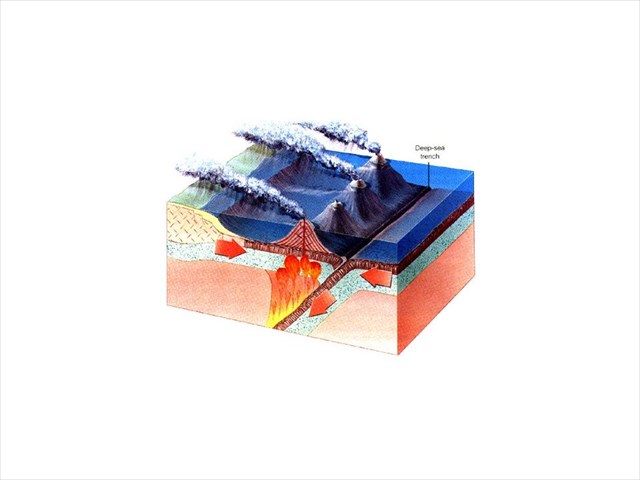
Figure 1. Subduction
What Lies Below
The bedrock of Mount Cardigan is composed of two distinct rocks. On the summit and to the east on the Clark Trail the bedrock is Cardigan Pluton. Beneath the granite dome lies older metamorphic schist. At timberline on the West Ridge Trail, the contact between the lighter color schist and the granite can be seen. (As an aside, the older schist is a small piece of the African continental plate that broke off as it slammed into North America about 100 million years earlier becoming permanently attached to North America – but that’s another story…)
Exfoliation
Exfoliation is the process in which granite domes weather by peeling off in sheets like an onion rather than eroding grain by grain. The word comes from the Latin folium, meaning "leaf". You can easily see layers in sedimentary rocks and in metamorphic rocks that originated as sedimentary; but, why does this happen in granite which does not form in layers? There is actually a controversy as to why this occurs. Some geologists think it’s due to the granite expanding and fracturing as pressure is released when the overlying rock is eroded. A newer theory says it’s simply gravity acting on the dome.
Megacryst
No, this is not the name of a heavy metal band. Megacrysts are just large crystals of potassium feldspar formed in the magma as it gradually cooled. The slower the cooling the larger the crystals. Geologists theorize these megacrysts formed because successive influx hot of magma kept the mass from cooling quickly.
Vein
Perhaps the most obvious feature on the granite dome of Mount Cardigan are the white veins that criss-cross through the rock. These formed when the magma domes cracked in the process of cooling. Hot steam containing dissolved silicon dioxide came up the cracks from below . This cooled quickly, forming uniform quartz in the cracks. When veins cool slower, quartz crystals have time to form and it is termed pegmatite.
Logging Requirements:
Please send me an email with your answers to the following questions:
1. Find an area of exfoliation near the posted coordinates. How thick are the exfoliating layers?
2. Take a look at the megacrysts. What is the largest crystal you can find? The smallest? Are they relatively uniform or do they vary in size? What does the crystal size tell you about the conditions that occurred when the pluton formed?
3 Examine several of the nearby veins. What is the thickest vein you can find? The thinnest? Can you appreciate quartz crystals within any of the veins? How does the width of the vein relate to the presence or absence of quartz crystals?
4. Optional: Weather permitting, enjoy the view. Post a picture if you want, but please no spoilers.
Sources:
The Granite Landscape: A Natural History of America's Mountain Domes, from Acadia to Yosemite by Tom Wessels Countryman Press, 2002
http://www.geologyuppervalley.com/p/mt-cardigan.html
http://www.conwaydailysun.com/outdoors/hiking/more-hikes/121417-mount-cardigan-a-wonderful-little-mountain
https://en.wikipedia.org/wiki/Cardigan_Pluton
Allen, T., (2001) Nappes, Gneiss Domes and Plutonic Sheets of West-Central New Hampshire in Timothy W. Grover, Helen N. Mango, and Edward J. Hasenohr, editors, Guidebook to Field Trips in Vermont and Adjacent New Hampshire and New York, New England Intercollegiate Geologic Conference, 89th Annual Meeting. pp. A2.1 - A2.19.
"Generalized Bedrock Geologic Map of New Hampshire" (PDF). NH Department of Environmental Services. Retrieved February 9, 2010.