
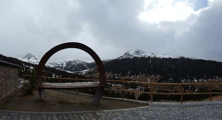
MIRADOR CIRQUE DE PESSONS
Un glaciar es una gruesa masa de hielo que se origina en la superficie terrestre por acumulación, compactación y re cristalización de la nieve, mostrando evidencias de flujo en el pasado o en la actualidad. Su existencia es posible cuando la precipitación anual de nieve supera la evaporada en verano. el proceso del crecimiento y establecimiento del glaciar se llama glaciación. Los glaciares del mundo son muy variados y se pueden clasificar por forma, régimen climático y condiciones térmicas.
El 10% de la Tierra está cubierta de glaciares, y en tiempos geológicos recientes ese porcentaje llego al 30%. Los glaciares acumulan más del 75% del agua dulce.
Los glaciares son producto del clima y están permanentemente intercambiando masa con otras partes del sistema hidrológico. Los glaciares crecen por la adición de nieve y otros tipos de hielo y pierden masa por fusión de huelo en agua y el desmembramiento de témpanos de hielo. La diferencia entre ganancia y pérdida de masa en un glaciar se denomina balance de masa.
Clasificación de glaciares según temperatura, morfología y topografía.
Temperatura:
Glaciar Temperado; Glaciar Subpolar; Glaciar Polar
Morfología:
Mantos de hielo y casquetes de hielo; Domo de hielo; Glaciar exhutorio; Corriente de hielo.
Topografía:
Campo de hielo; Glaciar de valle; Glaciares de transección; Glaciar de circo; Lóbulo de piedemonte; Glacierete; Apron de hielo; Franja de hielo; Glaciar marino; Elevación de hielo; Plataforma de hielo glaciar y Plataforma de hielo marina.
Transporte
Una vez que el material es incorporado al glaciar, puede ser transportado varios kilómetros antes de ser depositado. Todos los depósitos dejados por los glaciares reciben el nombre de derrubio glaciar.
El nombre más común para los sedimentos de los glaciares es el de morrena. En función de su posición respecto al flujo glaciar en el que son transportadas, hay tres tipos.
Morrenas externas: Compuestas por los fragmentos que caen sobre el hielo desde las laderas. Los fragmentos se suelen acumular en los márgenes de la lengua glaciar, formando una morrena lateral o en el frente formando una morrena frontal.
Morrenas internas: Compuestas por los materiales transportados dentro de la masa de hielo. Estos fragmentos proceden del exterior y han caído en la zona de alimentación, donde han sido recubiertos por neviza y se han hundido con ella.
Morrenas de fondo: Compuestas por fragmentos del exterior y del propio lecho, arrancados por la acción del hielo. Aparece cuando la ablación supera la acumulación.
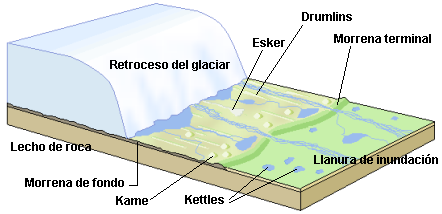
Acumulación
Los depósitos morrénicos proceden de la fusión del hielo, es decir cuando cede la acción transportadora del glaciar. Se acumulan en morrenas de retroceso, que marcan diferentes estadios en el retroceso del hielo glaciar. Las morrenas externas e internas se superponen a la de fondo, formando un solo depósito. Los elementos que componen la morrena están poco desgastados, y presentan estrías fruto de los roces entre sí. La morrena se caracteriza por la heterogeneidad de calibres, bloques angulosos, cantos, gravilla y arcilla, Las morrenas no se encuentran aisladas, sino que se forman sistemas de morrenas. Los más importantes son, los arcos morrénicos frontales, los cordones morrénicos laterales y las morrenas de ablación.
Los arcos morrénicos frontales se sitúan en el frente y en el borde externo de la lengua glaciar, tiene forma de media luna con un arco más ancho en el centro que en los laterales, donde suele enlazar con las morrenas laterales. En el caso de que el glaciar en lugar de retirarse crezca, aparece una morena de empuje.
Los cordones morrénicos laterales: Consisten en acumulaciones lineales desarrolladlas a lo largo del límite superior de sendas vertientes, y que pueden ir desde el área de alimentación hasta el frente. Los cordones pueden aparecer a distintas alturas dentro del valle glaciar, marcando distintas fases del retroceso, aunque suelen ser desmantelados por la dinámica de vertientes.
Las morrenas de ablación son aquellas que han sido sedimentadas sobre el lecho del glaciar. Presentan materiales heterogéneos, pero lo más característico es la presencia de grandes bloques dispersos a lo largo del trayecto denominado, bloques erráticos.
Los drumlins son colinas asimétricas de perfil aerodinámico compuestas principalmente por till. Su altura varía entre 15 a 50 metros y pueden medir hasta 1 km de longitud. El lado empinado del acolina mira la dirección desde la cual avanzó el hielo, mientras que la pendiente más larga sigue la dirección de desplazamiento del hielo
Transformación del terreno
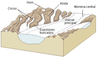
Sin el efecto de las glaciaciones los valles de montaña tienen una característica forma de V, producida por la erosión del agua en la vertical. Sin embargo, durante la glaciaciones esos valles se ensanchan y ahondan, lo que da lugar a la creación de un valle glaciar en forma de U. Además de su profundización y ensanchamiento, el glaciar también alisa los valles gracias a la erosión. De esta manera va eliminando los espolones de tierra que se extienden en el valle como resultado de esta interacción se crean acantilados triangulares llamados espolones truncados, debido a que muchos glaciares profundizan sus valles más de lo que hacen sus afluentes pequeños.
En la cabecera de un glaciar hay una estructura muy importante, se llama circo glaciar y tiene una forma de cubeta con paredes escarpadas en tres lados, pero con un lado a veces semiabierto que desciende hacia el valle. En los circos se da la acumulación de hielo. Estos empiezan como irregularidades en el lado de la montaña que luego van aumentando de tamaño por el acuñamiento del hielo. Después de que el glaciar se derrite, estos circos suelen ser ocupados por un pequeño lago de montaña denominado tarn.
PARA PODER REGISTRAR ESTE EARTH CACHE
Para poder registrar este Earthcache deberás responder a las siguientes preguntas.
P1. Situado en coordenadas frente a ti hay un panel informativo con el nombre de los accidentes geológicos que puedes observar. Está muy deteriorado, pero seguro que puedes rescatar algún dato.
P2. Según lo leído. ¿Donde se encuentra el 75% del agua dulce mundial?
P3. Según lo leído. ¿Que significa balance de masa?
P4. Situado en coordenadas. Geológicamente hablando, descríbeme donde te encuentras y que tienes frente a ti.
P5. Según lo leído. Nómbrame 2 tipos de glaciar por cada una de las maneras de clasificación (temperatura, morfología y clasificación)
OPCIONAL: manda una foto tuya o de tu GPS en el punto donde estas (evita fotos spoiler)
Una vez tengas todas las respuestas, envíamelas por mail y tras mandarlas siéntete libre de registrar el cache. En caso de existir algún fallo me pondré en contacto.

MIRADOR CIRQUE DE PESSONS
A glacier is a thick mass of ice that originates in the terrestrial surface by accumulation, crystallisation of the snow, showing evidences of flow in the past or in the actuality. His existence is possible when the annual precipitation of snow surpasses the evaporated in summer. The process of the growth and establishment of the glacier calls glaciation. The glaciers of the world are very varied and can classify by form, climate and thermal conditions.
10% of the Earth is covered of glaciers, and in recent geological times this percentage arrive to 30%. The glaciers accumulate more than 75% of the freshwater.
The glaciers are product of the climate and are permanently exchanging mass with other parts of the hydrological system. The glaciers grow by the addition of snow and other types of ice and lose mass by fusion of ice in water and the break of ice. The difference between gain and loss of mass in a glacier designates: balance of mass.
Classification of glaciers according to temperature, morphology and topography.
Temperature:
Glacier Temperado; Glacier Subpolar; Polar Glacier
Morphology:
Mantles of ice and sockets of ice; Dome of ice; Glacier *exhutorio; Current of ice.
Topography:
Field of ice; Glacier of valley; Glaciers of transectionn; Glacier of circus; Lobule of piedemonte; Apron of ice; Band of ice; marine Glacier; Elevation of ice; Platform of ice glacier and Platform of marine ice.
Transport
Once that the material is incorporated to the glacier, can be transported several kilometres before being deposited. All the tanks left by the glaciers receive the name of derrubio glacier.
The most common name for the sediments of the glaciers is the one of moraine. In function of his position with regard to the flow glacier in which they are transported, there are three types.
External moraine: Composed by the fragments that fall on the ice from the slopes. The fragments are used to accumulate in the margins of the tongue glacier, forming a lateral moraine or in the front forming a frontal moraine
Internal moraine: Composed by the materials transported inside the mass of ice. These fragments proceed of the outside and have fallen in the zone of feeding, where have been cover by snow and have sunk with her.
Background moraine: Composed by fragments of the outside and of the own mulch, started by the action of the ice. It appears when the ablation surpasses the accumulation.
Accumulation
The moraine tanks proceed of the fusion of the ice, that is to say when it yields the transport action of the glacier. They accumulate in moraines of shrinking, that mark different stadiums in the shrinking of the ice glacier. The external moraine and interns superimpose to the one of bottom, forming an alone tank. The elements that compose the moraine are little worn, and present groove fruit of brush them between himself. The moraine characterises by the heterogeneity of calibrate, angel blocks, singings, gravel and clay, The moraine do not find isolated, but they form systems of moraines.
The moraine cords sides: they Consist in linear accumulations develop them along the upper limit of both slopes, and that they can go from the area of feeding until the front. The cords can appear to distinct heights inside the fence in glacier, marking distinct phases of the shrinking, although they are used to to be dismantled by the dynamics of slopes.
The ablation of moraine are those that have been sedimentary on the mulch of the glacier. They present heterogeneous materials, but the most characteristic is the presence of big blocks along the distance designated, erratic blocks.
The drumlins are asymmetric hills of aerodynamic profile composed mainly by till. His height varies between 15 to 50 metres and can measure until 1 km of length. The steep side of the hill looks the direction from which advanced the ice, whereas the longest slope follows the direction of trip of the ice
Transformación del terreno
Without the effect of the glaciations the highland valleys have a characteristic form of V, produced by the erosion of the water in the vertical. However, during the glaciations these valleys widen and deepen, what gives place to the creation of a valley glacier in shape of Or. In addition to his broadening, the glacier also straightens the valleys thanks to the erosion. Of this way goes deleting the spurs of earth that extend in the valley like result of this interaction create triangular cliffs called spurs truncated, due to the fact that a lot of glaciers deepen his valleys more than what do his small tributaries.
In the top of a glacier there is a very important structure, calls circus glacier and has a form of basin with sheer walls in three sides, but with a side sometimes half-open that it descends to the valley. In the circuses gives the accumulation of ice. These begin like irregularities in the side of the mountain that afterwards go increasing of size by the pressure of the ice. After the glacier melts , these circuses are used to to be occupied by a small highland lake designated tarn.
TO BE ABLE TO REGISTER THIS EARTH CACHE
To be able to register this Earthcache will have to answer to the following questions.
P1. Situated in coordinates in front of you there is an informative signpost with the name of the geological accidents that you can observe. It's pretty damaged, but I'm sure there are some names and heights that you can recue for me...
P2. As the read. Where finds 75% of the world-wide freshwater?
P3. As the read. That means balance of mass?
P4. Situated in coordinates. Geologically speaking, describe me where find you and that have in front of you.
P5. As the read. Appoint me 2 types of glacier by each one of the ways of classification (temperature, morphology and classification)
OPTIONAL: Take a picture of you or your GPS at coordinates (avoids spoiler photos)
Once have all the answers, send them to me by mail and after commanding them seat you free to register the *cache. In case to exist some failure will put me in contact.