Sea Caves to Devil's Punch Bowl EarthCache
Sea Caves to Devil's Punch Bowl
-
Difficulty:
-

-
Terrain:
-
Size:  (not chosen)
Please note Use of geocaching.com services is subject to the terms and conditions
in our disclaimer.
This Earthcache is easily accessed off Highway 101, just
north of the town of Newport, Oregon. You can access Devil’s
Punch Bowl through Otter Rock. There is a large parking area right
next to the coords and can be easily visited by
everyone!
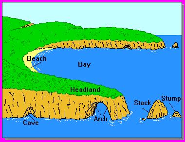
cave (kav) A naturally occurring underground hollow or passage,
especially one with an opening to the surface of the Earth. Caves
can form through a variety of processes, including the dissolution
of limestone by flowing water, the differential cooling of volcanic
magma (which occurs when the outside surface of the lava cools, but
the inside continues to flow downwards, forming a hollow tube), or
the action of wind and waves along a rocky coast.
Caves are found all over the face of the earth and can be
relatively small to enormous and extensive in their reaching into
the earth. Caves are formed by a multitude of means as well. In
this instance you are visiting the site of a former sea cave.
Sea caves occur on almost every cliffed headland or coast where the
waves break directly on a rock cliff and are formed by mechanical
erosion rather than the chemical solution process that is
responsible for the majority of inland caves. Sea caves are formed
by wave action on fractures or other weaknesses in the bedrock of
sea cliffs along coastlines. Zones of weakness in the cliff give
way under the force of the waves and are eroded out; these cavities
are enlarged by the hydraulic pressure built up by each wave. They
may be mere crevices in the cliff or roomy chambers. Some can be
entered only by boat at low tide, while others, occurring along
beaches, can be walked into. A sea cave may have an opening to the
surface at its rear that provides access from the top of the cliff.
Holes, commonly known as blowholes, may eventually be forced
through the roof of the cave to allow the pressure created by each
wave to be released as a jet of spray.
It took a very long time for the Devil’s Punch Bowl to
look the way it does today. For thousands of years, the Pacific
Ocean has carved the rocks of the land, sculpting this landscape
into unusual formations. The Oregon coast has been carved from the
California border to the Washington border by the brutal Pacific
waves. You can find sea caves at just about any spot you visit on
the Oregon coastline. In fact to the south of Devil’s Punch
Bowl, just north of Florence, you will find the world’s
largest sea cave. This is at the world famous Sea Lion Caves.
Before this became the punch bowl it is today this location
actually consisted of two sea caves. So before the punch bowl was
formed, waves pounding the coast beat against the walls of the two
sea caves, gradually wearing away the softer rock between them and
enlarging the cave. Waves beating against the roof of the sea cave
gradually eroded the rock of the cave ceiling. Eventually, the cave
roof collapsed, giving us the bowl we see today.
Looking at this spot today and imagining what it looked like a
thousand years ago and maybe even witnessing the collapse of the
roof, makes you wonder what this spot will look like 100 years from
now? The location could resemble nothing like it is today. With the
power of the might Pacific Ocean….you can bet it will be
incredible whatever it is!
So now back to present day…..below you is the spectacular
Devil’s Punch Bowl. With the collapse of the roof you can
watch the ocean waves crash through the openings in the sandstone,
continually sculpting this unusual formation. At high tide, the
waves churn through the openings below the water’s surface,
filling the cavern and creating the formation appropriately named
Devil’s Punch Bowl. This cliff overlooks a large intertidal
area that supports a wide variety of marine plants and animals.
Intertidal areas are regions along the shoreline that are submerged
for part of the tidal cycle and exposed during others. This
changing environment allows for a diversity of marine life that has
adapted to different levels of exposure to the air and the pounding
waves of surf. This area consists of large tide pools to explore
and a great beach to walk down. East of the parking area, posted
coords, there is a stairway, about 100 steps, that will take you
down to explore this rich habitat.
To log this EarthCache you must email me with the correct answers
to the following questions. Please do not post the answers in your
log on the cache page. Picture would be be a great addition to your
log but not mandatory. Failure to meet these very basic Earth Cache
requirements will see your log deleted from the space time
continuum.....oh and this cache page.
1. Give me your thoughts as to what Devil’s Punch Bowl will
look like in one hundred years. Will there be a Devil’s Punch
Bowl then?
2. The roof top to this sea cave collapsed many years ago. Estimate
the distance across the now open rooftop of Devil's Punch
Bowl.
3. What is the elevation of the posted coords?
4. Within the punch bowl parking area there is a famous landmark
establishment. What year was this place established?
5. Lastly take a picture of you and your GPSr standing in front of
the Devil’s Punch Bowl and upload it with your log.(This last
step is optional but a cache page with pictures with such an
incredible location is much more fun)

Additional Hints
(Decrypt)
Vs lbh pbagvahr hc gb Pncr Sbhyjrngure Ybbxbhg...lbh jvyy or gerngrq gb n terng nrevny ivrj bs gur nern! OEVAT GUNG PNZREN!! Terng nern sbe junyr jngpuvat!