|
 Laacher See: Mofetten Laacher See: Mofetten
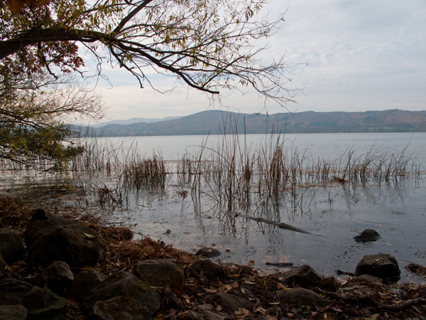
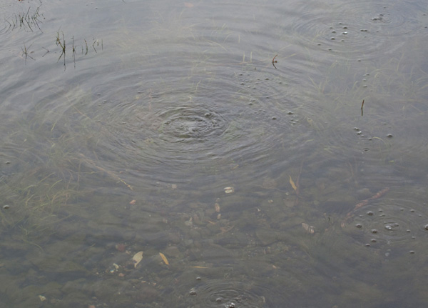
Dieser Earthcache führt euch zu den Kohlendioxid Quellen am Laacher See. Der Streifen indem das Gas austritt, ist einige hundert Meter lang. Die perlenden Gasblasen sind bei ruhigem Wasserspiegel gut zu sehen und gut zu hören. Das in der Tiefe erkaltete Magma gibt Kohlendioxid-Gas ab, welches hier auf dem Randabbruch des Laacher Kessels nach oben steigt. (Quelle: Informationstafel)
Ein Video der Mofetten ist in unserem EarthCache YouTube Channel zu sehen.
Eine Mofette ist eine kohlendioxidhaltige Quelle in Vulkangebieten, mitunter wird sie auch als kühlere Variante einer Fumarole aufgefasst. Definitionsgemäß haben Mofetten eine Gastemperatur unter dem Siedepunkt des Wassers. Der Begriff bezeichnet auch das Gas, das einer solchen Quelle entströmt.
Fumarolen sind vulkanische Exhalationen, d. h. Dampfaustrittsstellen, im Bereich von vulkanisch aktiven Gebieten, aus denen Wasserdampf und zum Teil vulkanische Gase austreten. Sie entstehen, wenn sich in der Tiefe nur wenig Wasser befindet. Durch den fehlenden Druck wird das Wasser vor seinem Austritt vollständig in Dampf umgewandelt. Fumarolen werden durch die Temperatur und Art der Gase, die aus ihnen austreten, klassifiziert. Exhalationen, die reich an Schwefelverbindungen wie Schwefelwasserstoff sind, werden Solfataren genannt; Kohlendioxid-Exhalationen heißen Mofetten. (Quelle: Wikipedia)
Die Fragen
Bitte begebt euch an die oben genannte Koordinate. In der Nähe befindet sich eine Informationstafel. Lest euch die Tafel bitte sorgfältig durch und beantwortet folgende Fragen:
- Woran kann man im Winter erkennen, dass an diesen Stellen Gas austritt?
- Bis zu welcher Distanz vom Ufer aus gesehen, kann man die Gasblasen erkennen (geschätzt)?
Achtung! Es werden genau die Angaben gesucht, die auf der Tafel gemacht werden! Internet Lösungen können leider nicht akzeptiert werden.
Die Log-Bedingungen
- Bitte schickt uns eine Email mit den Antworten für die Fragen.
Sehr Wichtig! Bitte gebt im Betreff den EarthCache Namen und euren GC Namen mit an!
- Bitte macht freiwillig ein Bild von euch oder eurem GPS am Ufer vor den Mofetten und fügt es eurem Log-Eintrag hinzu.
Ihr könnt dann sofort loggen.
Falls etwas nicht richtig ist, werden wir uns bei euch melden!
Wir hoffen euch macht dieser EarthCache genau so viel Spaß wie uns! Wir danken euch für euren Besuch und freuen uns auf eure Emails!
Liebe Grüße Kate!
Waymarking
In Kombination mit dem Cache kann auch der Waymark WM7PJR gelogged werden.
 Laacher Lake: Mofette Laacher Lake: Mofette
This EarthCache leads you to the carbon dioxide (CO2) springs along the Laacher Lake bank. The area of the bank where you can see those gas bubbles is several hundred meters long. The gas bubbles are good to see and hear when the water level is calm. The cooling of magma in the deep ist the origin of this carbon dioxide springs.
Watch this EarthCache location on YouTube or visit our YouTube EarthCache Channel.
The name mofetta is applied to a volcanic discharge consisting chiefly of carbon dioxide, often associated with other vapours, representing the final phase of volcanic activity. A mofetta has a temperature well below the boiling point of water, though above the temperature of the surrounding air.
A fumarole rich in in carbon dioxide is called a mofette. Fumarole are vents in the Earth’s surface from which volcanic gases are emitted. The major source of the gas bubbles emitted by fumaroles is groundwater heated by bodies of magma lying relatively close to the surface. Carbon dioxide, sulfur dioxide, and hydrogen sulfide are usually emitted directly from the magma. Fumaroles are often present on active volcanoes during periods of relative quiet between eruptions. They may persist for decades or centuries if they are above a persistent heat source or disappear within weeks to months if they occur atop a fresh volcanic deposit that quickly cools.
Questions
Please, head for coordinate mentioned above. Nearby is an information board. Read the board carefully by and answers the following questions:
- How can you possibly recognize the withdraw of the gas bubbles in winter?
- Up to how many meters in distance from the bank can you see those gas bubbles (estimated)?
Attention! The precise details are required, provided on the board! Unfortunately, solutions found in the internet cannot be accepted.
Log terms
- Please send us an Email with the answers to the questions above.Important! Please add your GC Name to Email Subject!
- Please take a optional picture of you or your GPS in front of the bank and add it to your log.
Logs without approval Email will be deleted without comment.
We hope you will enjoy this EarthCache as much as we do. We thank you for your visit and are looking forward to your Emails!
Kind regards, Kate!
Waymarking
In combination with this cache you can log Waymark WM7PJR.
Statistik / Statistics
Historie / History
- 17.11.2009 Listing erstellt. / Listing created.
- 20.11.2009 Listing aktualisiert. / Listing update.
- 07.12.2009 Deutsche Beschreibung. / German description.
- 08.12.2010 Geocoin entfernt. / Geocoin removed.
- 23.01.2011 Bild optional. / Picture optional.
- 17.07.2011 Log Bedingungen vereinfacht. / Log terms simplified.
- 13.05.2012 Opencaching entfernt. / Opencaching removed.
|