Högbergetin harvinaisen hieno virtauseroosioluola on muodostunut viimeisimmän jääkauden aikana, kun jäätikön alaiset sulamisvedet syöksyivät hurjalla paineella graniittikallion rakoon ja koversivat sinne vaakasuoran käytävän. Syvyyttä luolalla on noin 6,5 metriä, korkeutta metristä kahteen ja leveyttä noin metrin.
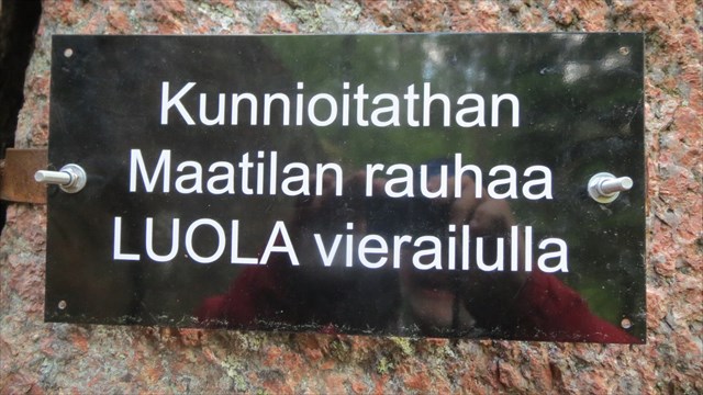
Luolaa kannattaa ehdottomasti lähestyä pohjoispuolelta, eteläpuolelta yrittävät voivat joutua parkkipaikkaa etsiskellessään läheisen maatilan pihapiiriin, mikä ei ole tietenkään toivottavaa. Hyvää parkkipaikkaa ei ole, mutta omalla riskillä voi ajopelin jättää trailheadin koordinaatteihin pientareelle. Trailheadista mene lyhyen metsäkaistaleen poikki pellon laitaan ja tulet hyvälle trailille, joka vie luolalle. Matkaa kertyy 750 m. Suoraan trailheadista luolalle matkaa on n. 350 m.
Suomen luolista
Luolat jaetaan alkuperän perusteella primääriluoliin ja sekundäärisiin luoliin. Primääriluola muodostuu samalla, kun kivi sen ympärillä muuttuu kiinteäksi (esimerkiksi laavatunneli), sekundäärinen luola taas muodostuu ympäröivän kiven jo kiinteydyttyä tai kerrostuttua. Suurin osa luolista on sekundäärisiä.
Sekundäärisiä luolia syntyy monella eri tavalla kemiallisessa rapautumisessa, mekaanisessa kulutuksessa, maankuoren tai jään liikkeissä. Esimerkiksi pääasiassa kalsiumkarbonaatista (CaCO3) koostuva kalkkikivi on altis veden aiheuttamalle kemialliselle hyökkäykselle. Tapahtuu kiviaineksen liukenemista, josta pitkän ajan kuluessa syntyy luola. Uudenmaan tunnetuin kalkkikiviluola on Torholan luola Lohjalla. Kiviaines, joka ei sisällä kalsiumkarbonaattia (esimerkiksi graniitti), ei liukene kemiallisesti, mutta vaakasuoria onkaloita syntyy eroosion tuloksena samoin kuin pystysuoria hiidenkirnuja. Myös jääkauden aiheuttamat maankuoren liikkeet saattavat halkoa kalliota tai pinota lohkareita röykkiöiksi siten, että lohkareiden väliin muodostuu koloja. Mikäli tällainen kolo on riittävän suuri, se voidaan katsoa luolaksi.
Suomen graniittivoittoisessa kallioperässä primääriluolia ei esiinny ja monet sekundääriluolatyypitkin ovat harvinaisia. Suomessa luolaksi määritellään kallioperän tai maaperän onkalo, johon mahtuu mukavasti ainakin 2-3 ihmistä, tai kalliolipat tms. suuret tilat, joiden alle voi leiriytyä ainakin 10 ihmistä. Myös pienempi onkalo, jolla on geologista tai historiallista arvoa, voidaan laskea luolaksi. Suomen luolat ovat enimmäkseen lohkareluolia, jotka syntyivät, kun jääkausi kuljetti kiviä ja kasasi niitä päällekkäin. Myös kivien romahtaminen veden kuluttamaan laaksoon saattoi aikaansaada lohkareluolia. Uudellamaalla näitä lohkareluolia on runsaasti mm. Nuuksiossa.
Lähetä omistajalle vastaus seuraaviin kysymyksiin:
- Kuinka korkea luola on korkeimmillaan suuaukon kohdalla?
- Mistä voi päätellä, että luola on eroosion aikaansaama eikä lohkareluola?
- Mitä värejä näit luolan seinissä? Mistä ne johtuvat?
- Näitkö luolassa eläimiä tai kasveja? Mitä?
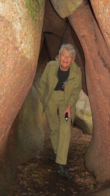
- Vapaaehtoinen: liitä kuva itsestäsi tai kepsustasi luolassa tai sen suulla
Voit logata kätkön odottamatta loggauslupaa. Omistaja ottaa sinuun tarvittaessa yhteyttä.
Lähteet: Wikipedia, retkipaikka.fi, http://www.esi.utexas.edu/outreach/caves/caves.php
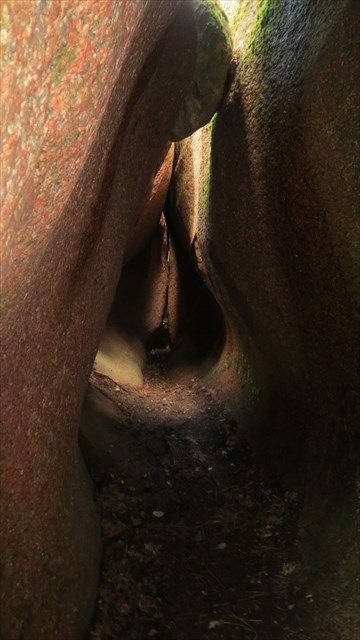
The spectacular erosion cave in Högberget was formed during the last Ice Age when under the ice melting waters rushed with enormous force into a crack in the granite rock and carved a cave which is about 6,5 m long, 1-2 metres high and 1 metre wide.
You should approach the cave from the north, trying to access the cave by car from the south leads easily to trespassing which is unacceptable. There is no proper parking place but on your own risk you may leave your car at the trailhead on the roadside. From the trailhead cross the narrow strip of woods down to the field. From there you can follow a good trail all the way to the cave. Distance 750 m. Distance from the trailhead directly to the cave is about 350 m.
About Caves in Finland
There are two main types of caves: primary and secondary. A primary cave is formed at the same time as the rock material around it becomes solid (e.g., lava tube). A secondary cave develops when surrounding rock material has already solidified or formed layers. Most caves are secondary.
There are many phenomena that can cause a secondary cave to develop. Secondary caves can emerge in a chemical process, mechanical erosion or as result of earth or ice movements. For instance, limestone which consists primarily of calcite (CaCO3) is vulnerable to chemical attack by groundwater. During a long period of time the solution process can create a cave. The most famous limestone cave in Uudenmaa is the Torhola cave in Lohja. When there is no calcite (e.g. granite) there is no chemical solution but mechanical erosion can create horizontal cracks and tunnels same way as it forms vertical holes known as giant's kettles. Also earth movements caused by the Ice Age split rock and piled boulders so that hollow spaces were formed between them. When big enough, they are called caves.
Rock material in Finland is mostly granite and there are no primary caves. Many secondary cave types are also rare. By definition, in Finland, a hollow cave type space can be called a cave, if it has room for 2-3 people. Same goes for an overhanging cliff if 10 people can camp under it. A smaller cave type space with geological or historical value can also be considered a cave. Most caves in Finland are boulder caves, which were formed when during the Ice Age boulders were transported by ice and piled together. Sometimes caves were formed when boulders fell down to a valley carved by water. In Uusimaa there are many boulder caves, e.g., in Nuuksio.
To log this ec, send the owner answers to the following questions:
- What is the maximum height of the cave at the entrance?
- How can one see that this is an erosion cave and not a boulder cave?
- What colours did you see on the walls? What is the cause of different colours?
- Did you see any animals or plants in the cave? Describe.
- Optional: attach a picture of yourself or your GPS in the cave or at the entrance
You can log the ec without waiting for a response. The owner will contact you, if necessary.
Sources: Wikipedia, retkipaikka.fi, http://www.esi.utexas.edu/outreach/caves/caves.php